
Cranston, formerly known as Pawtuxet, is a city in Providence County, Rhode Island, United States. The official population of the city in the 2020 United States Census was 82,934, making it the second-largest city in the state. The center of population of Rhode Island is located in Cranston. Cranston is a part of the Providence metropolitan area.

Ward's Point is the southernmost point in the U.S. state of New York and lies within Tottenville, Staten Island, New York City. It is located at the mouth of Arthur Kill, across from Perth Amboy, New Jersey, at the head of Raritan Bay. The site is part of modern-day Conference House Park.
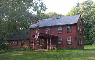
Oak Lawn or Oaklawn is a historical village in southwest Cranston, Rhode Island. Prior to being named "Oak Lawn" in 1872 the area was known as "Searle's Corner". The Edward Searle House, built in 1677, and one of the oldest standing structures in Rhode Island, is located in Oak Lawn. The village is known for its annual May Breakfast, a New England tradition that began in Oak Lawn in 1865 as a way for the members of the Oak Lawn Baptist Church to raise money for local American Civil War veterans. The 1855 Herman Melville novel "Israel Potter" is based on the life and adventures of an American Revolutionary soldier who was raised on a farm near present-day Oak Lawn. Oak Lawn is also the site of an important archeological excavation: in the 1950s archeologists discovered bowls and other Native American artifacts, carved from soapstone and dating back more than 10,000 years. In the pre-colonial era the area was populated with bands of the Narragansett Indians known as the "Meshanticut" and "Natick" Indians.

Pawtuxet Village is a section of the New England cities of Warwick and Cranston, Rhode Island, United States. It is located at the point where the Pawtuxet River flows into the Providence River and Narragansett Bay.

Union Village or "Bank Village" is a village and historic district located in North Smithfield and Woonsocket, Rhode Island on Rhode Island Route 146A. Union Village developed because it was at the cross roads of old Great Road and Pound Hill Road.

The Brooks River Archaeological District encompasses a large complex of archaeological sites along the banks of the Brooks River in Katmai National Park and Preserve in the U.S. state of Alaska. It includes at least twenty separate settlement sites with documented occupation dates from 2500 BCE to recent (post-contact) history. It was declared a National Historic Landmark in 1993. The site is partly occupied by the Brooks Camp, one of the major visitor areas of the park.
The Hazard Farmstead is a historic archaeological site in Jamestown, Rhode Island. It is the location of a major American Indian settlement whose artifacts have been dated from 2,500 BC to 1,000 AD. It appeared to be occupied seasonally from late summer to fall, and was intensively used during those times.
The Jamestown Archeological District is an expansive archaeological district which is the site of a major prehistoric Native American settlement in Jamestown, Rhode Island. The full extent of archaeologically-sensitive areas has not been fully identified, but is known to extend from Narragansett Avenue in the south to Rhode Island Route 138 in the north, and from Narragansett Bay in the west to North Road. The district overlaps the historically significant Windmill Hill Historic District, and the nearly 300-acre (120 ha) Watson Farm. The district includes one of largest Native American burying grounds in New England, and includes evidence of occupation dating to 3,000 BC.

The Sassafras Site, designated RI-55, is a prehistoric archaeological site in Albion, a village of Lincoln, Rhode Island. The site was discovered by archaeologists while surveying an area for a potential replacement for the Albion Street bridge, which spans the Blackstone River between Lincoln and Cumberland. The site encompasses a regionally significant quartz stone tool workshop.

The Hope Village Historic District is a historic rural mill settlement within Hope Village in Scituate, Rhode Island. Hope Village is located on a bend in the North Pawtuxet River in the southeastern corner of Scituate. Industrial activity has occurred in Hope Village since the mid-eighteenth century. Surviving industrial and residential buildings in the Historic District date back to the early 19th century. The village center sits at junction of Main Street and North Road. Hope Village radiates out from the center with houses on several smaller side streets in a compact configuration. Currently there is little commercial or industrial activity in Hope Village and none in the Historic District. The present stone mill building on the south side of Hope Village was built in 1844 by Brown & Ives of Providence, expanded in 1871 and modified in 1910. Approximately one quarter of the village's current housing stock was built as mill worker housing by various owners of Hope Mill.
The Moosup River Site (RI-1153) is an archaeological site in Coventry, Rhode Island. The site is located on a bluff overlooking the Moosup River in western Coventry, not far from the Connecticut state line. The site was identified and excavated in 1985, yielding a quartzite Neville point, and radiocarbon dates to 3050 BCE.
The Sharon Valley Historic District is located around the junction of Kings Hill, Sharon Valley and Sharon Station roads in Sharon, Connecticut, United States. It is a small community that grew up around an iron mining and refining operation during the late 19th century, the first industry in Sharon.

The Massachusetts Hornfels-Braintree Slate Quarry is a prehistoric archaeological site in Milton and Quincy, Massachusetts. It consists of a series of pits and trenches used from 7,000 B.P. until the early 17th century as a source of slate and hornfels used for chipped and ground tools. Pieces made from material quarried at the site are found over much of eastern Massachusetts. The site was added to the National Register of Historic Places in 1980.

The Pequot Fort was a fortified Native American village in what is now the Groton side of Mystic, Connecticut, United States. Located atop a ridge overlooking the Mystic River, it was a palisaded settlement of the Pequot tribe until its destruction by Puritan and Mohegan forces in the 1637 Mystic massacre during the Pequot War. The exact location of its archaeological remains is not certain, but it is commemorated by a small memorial at Pequot Avenue and Clift Street. The site previously included a statue of Major John Mason, who led the forces that destroyed the fort; it was removed in 1995 after protests by Pequot tribal members. The archaeological site was added to the National Register of Historic Places in 1990.

Old Town is an archaeological site in Williamson County, Tennessee near Franklin. The site includes the remnants of a Native American village and mound complex of the Mississippian culture, and is listed on the National Register of Historic Places (NRHP) as Old Town Archaeological Site (40WM2).

The Indian Hill Avenue Historic District encompasses an 18th-century colonial shipbuilding village, overlaid on a historic and prehistoric Native American settlement, in Portland, Connecticut. Extending along Indian Hill Avenue north of Portland, the district includes a collection of 18th and early 19th-century buildings, and extensive archaeological evidence of Native American occupation. The district was listed on the National Register of Historic Places in 1983.
The Baum Site (31Ck9) is one of the most prominent Middle and Late Woodland Period sites of the Colington Phase in the state of North Carolina. It is located north of Poplar Branch in Currituck County, North Carolina. This phase, marked by cultures of the Algonkian peoples, aligns with the Late Woodland period in North Carolina, occurring during English explorations between 1584 and 1587, and permanent settlement at 1650. This village is what the first English explorers encountered when entering the coastal region. The site contained ossuaries and evidence for a coastal village adaptation. The site was registered with the National Register of Historic Places on December 8, 1982, after testing and excavations in 1972 and 1973 by David Sutton Phelps, who was an archaeologist at East Carolina University. The site is suffering from erosion due to wave action. After the initial discovery, which was the result of erosion uncovering of remains, Phelps claimed, “this will provide the first glimpse of a coastal village of this type in the state”. A residential subdivision, Currituck Crossing, is now located on the Baum site. https://web.archive.org/web/20160617035403/http://co.currituck.nc.us/pdf/board-of-commissioners-minutes-2013/boc-minutes-13nov04.pdf.
The Beaver Meadow Complex Prehistoric Archeological District is a grouping of archaeological sites in Peoples State Forest, Barkhamsted, Connecticut. It consists of eight separate sites in the Beaver Meadow area of the forest, from which radiocarbon dates from the Archaic to the Middle and Late Woodland Period have been obtained. The sites were identified during surveys conducted 1983-85 by teams from Central Connecticut State University. This work was done as part of a larger scale survey of the Connecticut sections of the upper Farmington River valley.

The Barkhamsted Lighthouse was a historical community located in what is now Peoples State Forest in Barkhamsted, Connecticut. Set on a terrace above the eastern bank of the West Branch Farmington River, it was in the 18th and 19th centuries a small village of economically marginalized mixed Native American, African American, and white residents. It was given the name "lighthouse" because its lights acted as a beacon marking the north–south stage road that paralleled the river. The archaeological remains of the village site were listed on the National Register of Historic Places in 1991 as Lighthouse Archeological Site (5-37).
