
The Northwest Miramichi River or Elmunokun is a river in New Brunswick, Canada. The Mi'kmaq referred to the river as Elmunokun, possibly meaning "a beaver hole" in reference to a deep pool in the river, just below the mouth of the Big Sevogle River, its second largest tributary, after the Little Southwest Miramichi.

The Southwest Miramichi River is a river in New Brunswick, Canada.
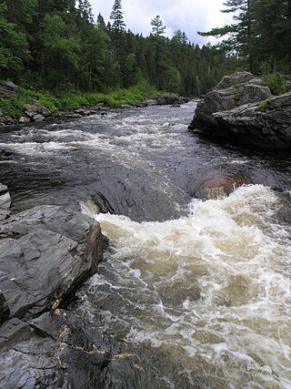
"Push and Be Damned Rapids" is the evocative name for rapids on the Southwest Miramichi River, one of the many tributaries of the Miramichi River, New Brunswick, Canada, near the village of Juniper.
The Little Southwest Miramichi River is a river in Northumberland County, New Brunswick, Canada. In Mi'kmaq it is referred to as "Tooadook".

The Renous River is a tributary of the Southwest Miramichi River in New Brunswick, Canada.

The Dungarvon River is a tributary of the Renous River in New Brunswick, Canada.
The Napan River in Canada is a tributary of the Miramichi River in New Brunswick, Canada. The river rises several kilometres southwest of Chatham in central Northumberland County and flows northeast into the Miramichi River at Napan Bay. Four bridges cross the river at various points: at Hannah Lane, Highway 11, Johnston Lane, and Highway 117. There was also once a crossing at White Lane. At one time, these bridges were covered, although all have been upgraded to steel and concrete structures.
The Tobique River is a river in northwestern New Brunswick, Canada. The river rises from Nictau Lake in Mount Carleton Provincial Park and flows for 148 kilometres to its confluence with the Saint John River near Perth-Andover.
The Esk'etemc First Nation, also known as the Alkali Lake Indian Band, is a First Nations government of the Secwepemc (Shuswap) people, located at Alkali Lake in the Cariboo region of the Central Interior of the Canadian province of British Columbia. It was created when the government of the then-Colony of British Columbia established an Indian reserve system in the 1860s. It is one of three Secwepemc bands that is not a member of either the Shuswap Nation Tribal Council or the Northern Shuswap Tribal Council.
The Nazko First Nation is a First Nations government of the Dakelh people in the north-central Interior of British Columbia. Its reserves are located around the community of Nazko, British Columbia, which is 120 km west of Quesnel and southwest of Prince George.

Weldford is a geographic parish in Kent County, New Brunswick, Canada.
The Barnaby River is a tributary of the Miramichi River in New Brunswick, Canada.
Route 123 is a mostly North/South provincial highway in the Canadian province of New Brunswick. The road runs from Route 10 in Chipman. The road has a length of approximately 52 kilometres, and services small, otherwise isolated rural communities. In these areas, the highway is often unofficially referred to as "Main Street." The Highway is known as Main Street and McLeod Avenue in Chipman. The road is then known as Grand Lake Road from Gaspereau Forks to Doaktown. Lastly upon entering Doaktown, the road is named South Road.

Botsford is a geographic parish in Westmorland County, New Brunswick, Canada.

Brunswick is a geographic parish in the northeastern corner of Queens County, New Brunswick, Canada.
Chipman is a geographic parish in Queens County, New Brunswick, Canada.
Fraser Mills was a municipality in British Columbia on the north bank of the Fraser River that was incorporated in 1913, but has since amalgamated with the City of Coquitlam.

The Gaspereau River is a river in Kings County, Nova Scotia, Canada.

The Salmon River is a small river in central New Brunswick, Canada. It flows into Grand Lake near Chipman. It is part of the Saint John River watershed.

The Gaspereau River is a small river in southeastern New Brunswick, Canada. It is located Westmorland County and flows from Square Lake into Baie Verte, a sub-basin of the Northumberland Strait, at Port Elgin.
