Related Research Articles
The National Register of Historic Places (NRHP) is the United States federal government's official list of districts, sites, buildings, structures, and objects deemed worthy of preservation for their historical significance or "great artistic value". A property listed in the National Register, or located within a National Register Historic District, may qualify for tax incentives derived from the total value of expenses incurred in preserving the property.

The National Historic Preservation Act is legislation intended to preserve historic and archaeological sites in the United States of America. The act created the National Register of Historic Places, the list of National Historic Landmarks, and the State Historic Preservation Offices.

This is a list of properties and historic districts in Washington that are listed on the National Register of Historic Places. There are at least three listings in each of Washington's 39 counties.

This is a list of the National Register of Historic Places listings in St. Louis County, Missouri.

This is a list of properties and historic districts in Missouri on the National Register of Historic Places. There are NRHP listings in all of Missouri's 114 counties and the one independent city of St. Louis.

Washington State Park is a public recreation area covering 2,147 acres (869 ha) in Washington County in the central eastern part of the state of Missouri. It is located on Highway 21 about 14 miles (23 km) northeast of Potosi or 7 miles (11 km) southwest of DeSoto on the eastern edge of the Ozarks. The state park is noted for its Native American rock carvings and for its finely crafted stonework from the 1930s.

The U.S. National Register of Historic Places (NRHP) classifies its listings by various types of properties. Listed properties generally fall into one of five categories, though there are special considerations for other types of properties which do not fit into these five broad categories or fit into more specialized subcategories. The five general categories for NRHP properties are: building, district, object, site, and structure.
The Indiana Register of Historic Sites and Structures was created in 1981 by the Indiana General Assembly. The Survey and Registration Section of the Indiana Division of Historic Preservation and Archaeology oversees this state register. All places within Indiana that are listed on the National Register of Historic Places are automatically on Indiana's Register. Additional sites are on the state register, as the state's register does not require as many documents and sources for inclusion.
This is a list of properties and historic districts within the Downtown St. Louis and Downtown West, St. Louis areas of the city of St. Louis, Missouri that are listed on the National Register of Historic Places. The downtown area is defined by Cole Street to the north, the river front to the east, Chouteau Avenue to the south, and Jefferson Avenue to the west. Tucker Avenue divides Downtown to the east from Downtown West to the west.

This is a list of the National Register of Historic Places listings in Mississippi County, Missouri.
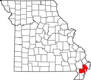
This is a list of the National Register of Historic Places listings in New Madrid County, Missouri.
References
- 1 2 "National Register Information System". National Register of Historic Places . National Park Service. July 9, 2010.
- ↑ State Historic Preservation Office (n.d.). "Preservation Horizons: 2011-2017: Missouri's Comprehensive Statewide Historic Preservation Plan" (PDF). Missouri Department of Natural Resources. Retrieved November 1, 2016.]
