General Wayne A. Downing Peoria International Airport

Last updated

General Wayne A. Downing Peoria International Airport
General Wayne A. Downing Peoria International Airport Logo.jpg
Peoria Airport Terminal.jpg
Summary
Airport typePublic
Owner/OperatorMetropolitan Airport Authority of Peoria
Serves Peoria, Illinois
Location Limestone Township, Peoria County
OpenedMay 19 1932;91 years ago (May 19 1932)
Elevation  AMSL 661 ft / 201 m
Coordinates 40°39′51″N089°41′36″W / 40.66417°N 89.69333°W / 40.66417; -89.69333
Website www.FlyPIA.com
Maps
PIA Airport Diagram.pdf
FAA airport diagram
General Wayne A. Downing Peoria International Airport
Runways
Direction LengthSurface
ftm
13/3110,1043,080Concrete
4/228,0042,440Asphalt
Statistics
Passengers (2021)480,006
Aircraft operations (year ending 8/31/2023)38,805
Based aircraft (2023)63
Sources: Airport [1] and FAA [2]

General Wayne A. Downing Peoria International Airport [3] ( IATA : PIA [4] , ICAO : KPIA, FAA LID : PIA) is a civil/military public airport five miles west of Peoria, in Peoria County, Illinois, United States. [2] It is on the northwest edge of Bartonville, near Bellevue. It is owned by the Metropolitan Airport Authority of Peoria, [2] which often refers to it as Peoria International Airport. [5] [6] It was formerly the Greater Peoria Regional Airport. [7] [8]

Contents

The Federal Aviation Administration (FAA) National Plan of Integrated Airport Systems for 2017–2021 categorized it as a non-hub primary commercial service facility. [9] Federal Aviation Administration records say the airport had 312,378 passenger boardings (enplanements) in calendar year 2017 and 328,769 in 2018. [10]

History

Peoria Airport KTrimble-KPIA Aerial 2017-08-12 7500msl.jpg
Peoria Airport

On May 19, 1932, the citizens of Peoria voted to have an airport. On 195 acres (0.8 km2), American Airways (now American Airlines) and Chicago and Southern Airlines brought in airmail and passenger services on four shale-surfaced runways. The land was purchased by 261 Peoria businessmen who formed the Peoria Airport, Inc. [11] It was turned over to the Peoria Park District in 1937, then to the newly formed Metropolitan Airport Authority of Peoria in 1950.

American Airlines and Chicago and Southern started flights to Peoria in 1945; C&S pulled out in 1949-50 and American left in 1962, then returned for a couple years starting in 1991. TWA served Peoria 1947 to 1960 and 1983 to 1991; Continental from 1977 to 1983; United from 1984 to 1995; Republic/Northwest 1986 to 1988; and Ozark from 1950 until it merged into TWA. Peoria's first jets were Ozark DC9s in 1966. A curious artifact of airline regulation: Peoria never had nonstop flights beyond Chicago until Ozark was allowed a nonstop to New York La Guardia in 1969.

On April 25, 2007, the Greater Peoria Airport Authority announced a new nine-gate terminal will be built and the old building demolished. On October 10, 2008, the airport was renamed "General Wayne A. Downing Peoria International Airport" during a groundbreaking ceremony attended by Ross Perot, a friend of the late Wayne A. Downing. [3] [12] [6] The new terminal, designed by Reynolds, Smith & Hills of Jacksonville, Florida and the Dewberry architecture firm of Peoria, and built by Turner Construction, opened on April 27, 2011. [13] [14] As of August 24, 2012, the airport was in negotiations for international flights using a temporary customs facility. [15]

In 2016, the Ray Lahood International Arrivals Terminal was completed, with more gates, TSA services, and a US Customs Port of Entry facility. [16] [17]

In December 2020, Delta Air Lines pulled all its flights from Peoria. [18]

The airport authority selected a site for a new control tower in 2012, with a design phase from 2013 to 2015 and finalized in 2017; however, funding dried up before a new tower was built. [19] As of May 2023, the airport is planning to use funds from the Bipartisan Infrastructure Bill and updating design plans to incorporate FAA requirement changes since 2017. [19]

Facilities and aircraft

Peoria International Airport covers 3,800 acres (1,538 ha) at an elevation of 661 feet (201 m). It has two runways: 13/31 is 10,104 by 150 feet (3,080 x 46 m) concrete; 4/22 is 8,004 by 150 feet (2,440 x 46 m) concrete. [2] [20] [6]

For the 12-month period ending August 31, 2023, the airport had 38,805 operations, an average of 106 per day: 57% general aviation, 16% military, 14% commercial, and 14% air taxi. [21] At that time, 63 aircraft were based at this airport: 33 single-engine, 5 multi-engine airplanes, 14 military, 8 jet, 2 helicopters, and 1 ultralight. [2]

Military

The airport is co-located with the Peoria Air National Guard Base, home to the 182d Airlift Wing (182 AW) of the Illinois Air National Guard. This Air National Guard unit is operationally-gained by the Air Mobility Command (AMC) and consists of Lockheed C-130H Hercules aircraft. [6] The airport is also home to the Illinois Army National Guard's Army Aviation Support Facility No. 3 and 1st Battalion, 106th Aviation Regiment, currently operating the Boeing CH-47 "Chinook" helicopter. [6]

Airlines and destinations

Passenger

AirlinesDestinationsRefs
Allegiant Air Fort Lauderdale, [22] Las Vegas, Orlando/Sanford, Phoenix/Mesa, Punta Gorda (FL), St. Petersburg/Clearwater
Seasonal: Denver, [23] Destin/Fort Walton Beach, Nashville, Sarasota
[24]
American Eagle Charlotte, Chicago–O'Hare, Dallas/Fort Worth [25]
United Express Chicago–O'Hare [26]

Cargo

AirlinesDestinations
UPS Airlines Louisville, Rockford, Miami

Statistics

Airline market share

Carrier shares for (April 2022 – March 2023) [27]
CarrierPassengers (arriving and departing)
Allegiant
300,000(50.75%)
PSA
81,000(13.78%)
Mesa
77,000(13.05%)
Envoy Air
65,000(10.91%)
Air Wisconsin
57,000(9.66%)
Other
11,000(1.85%)
Top domestic destinations (April 2022 – March 2023) [27]
RankCityPassengersAirlines
1 Flag of Illinois.svg Chicago–O'Hare, Illinois 61,000 American, United
2 Flag of Texas.svg Dallas/Fort Worth, Texas 44,000 American
3 Flag of North Carolina.svg Charlotte, North Carolina 40,000 American
4 Flag of Arizona.svg Phoenix–Mesa, Arizona 25,000 Allegiant
5 Flag of Florida.svg Punta Gorda/Ft. Myers, Florida 25,000 Allegiant
6 Flag of Florida.svg St. Petersburg/Clearwater, Florida 24,000 Allegiant
7 Flag of Nevada.svg Las Vegas, Nevada 19,000 Allegiant
8 Flag of Florida.svg Orlando–Sanford, Florida 16,000 Allegiant
9 Flag of Colorado.svg Denver, Colorado 13,000 Allegiant
10 Flag of Florida.svg Sarasota–Bradenton, Florida 11,000 Allegiant

Ground transportation

Public transit service to the airport is provided by the Greater Peoria Mass Transit District. Route 7 operates daily from downtown Peoria to the airport. [28]

Accidents and incidents

See also

Notes

  1. According to the Aviation Safety Network report, [29] the airline involved in the accident was founded in 1969 and ended operations in 1971. Chicago and Southern Air Lines was a completely different airline that was founded in California in 1933 and merged in 1953 with Delta Air Lines to become Delta-C&S for two years until 1955, reverting to Delta Air Lines.

Related Research Articles

<span class="mw-page-title-main">Gerald R. Ford International Airport</span> Airport in Michigan, US

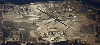
Grand Rapids Gerald R. Ford International Airport is a commercial airport in Cascade Township, approximately 13 miles (21 km) southeast of Grand Rapids, Michigan, United States. The facility is owned by the Kent County Board of Commissioners and managed by an independent authority. The US Federal Aviation Administration (FAA) National Plan of Integrated Airport Systems for 2017–2021 categorized it as a small hub primary commercial service facility.

<span class="mw-page-title-main">Eugene Airport</span> Airport in near Eugene, Oregon

Eugene Airport, also known as Mahlon Sweet Field, is a public airport 7 miles (11 km) northwest of Eugene, in Lane County, Oregon, United States. Owned and operated by the City of Eugene, it is the fifth-largest airport in the Pacific Northwest.

<span class="mw-page-title-main">Norfolk International Airport</span> Airport in Norfolk, Virginia

Norfolk International Airport is seven miles (11 km) northeast of downtown Norfolk, an independent city in Virginia, United States. It is owned and operated by the Norfolk Airport Authority: a bureau under the municipal government. The airport serves the Hampton Roads metropolitan area of southeast Virginia as well as northeast North Carolina. Despite its name, the airport does not have any international destinations nonstop.

<span class="mw-page-title-main">Richmond International Airport</span> Airport in Virginia, U.S.

Richmond International Airport is a joint civil-military airport in Sandston, Virginia, United States, an unincorporated community. The airport is about 7 miles (11 km) southeast of downtown Richmond, the capital of the Commonwealth of Virginia. Richmond International Airport is the busiest airport in central Virginia and the fourth-busiest in the state behind Washington Reagan, Washington Dulles, and Norfolk International. RIC covers 2,500 acres of land.

<span class="mw-page-title-main">Indianapolis International Airport</span> Airport in Indianapolis, Indiana, U.S.

Indianapolis International Airport is an international airport located seven miles (11 km) southwest of downtown Indianapolis in Marion County, Indiana, United States. It is owned and operated by the Indianapolis Airport Authority. The Federal Aviation Administration (FAA) National Plan of Integrated Airport Systems for 2017–2021 categorized it as a medium hub primary commercial service facility. The airport has flights to over 40 destinations in the United States, Canada and Mexico.

<span class="mw-page-title-main">Fort Wayne International Airport</span> Airport in Fort Wayne, Indiana, US

Fort Wayne International Airport lies eight miles southwest of Fort Wayne, in Allen County, Indiana, United States. It is owned by the Fort Wayne-Allen County Airport Authority.

<span class="mw-page-title-main">St. Pete–Clearwater International Airport</span> Third busiest airport serving the Tampa Bay area, Florida, United States

St. Pete–Clearwater International Airport is a public/military airport in Pinellas County, Florida, United States, serving the Tampa Bay Area. It is right on the northeast municipal boundary of Pinellas Park, 9 miles (14 km) north of downtown St. Petersburg, 7 miles (11 km) southeast of Clearwater, and 17 miles (27 km) southwest of Tampa.

<span class="mw-page-title-main">Asheville Regional Airport</span> Airport located in Fletcher, North Carolina, USA

Asheville Regional Airport is a Class C airport near Interstate 26 and the town of Fletcher, North Carolina, 9 miles (14 km) south of downtown Asheville. It is owned by the Greater Asheville Regional Airport Authority. The Federal Aviation Administration (FAA) National Plan of Integrated Airport Systems for 2019–2023 categorized it as a small-hub primary commercial service facility. In 2023 it served an all-time record number of passengers for the airport, 2,246,411, an increase of 22.2% over 2022.

<span class="mw-page-title-main">Lehigh Valley International Airport</span> Airport serving Hanover Township, Pennsylvania, USA

Lehigh Valley International Airport, formerly Allentown–Bethlehem–Easton International Airport, is a domestic airport located in Hanover Township in Lehigh County, Pennsylvania. Lehigh Valley International Airport is located in the center of the Lehigh Valley, roughly 7 miles (11 km) northeast of Allentown, 4 miles (6.4 km) northwest of Bethlehem, and 11 miles (18 km) southwest of Easton.

<span class="mw-page-title-main">Quad Cities International Airport</span> Airport in Moline, Illinois, United States

Quad Cities International Airport is a public airport in Rock Island County, Illinois, three miles (5 km) south of Moline, partly in Blackhawk Township and partly in Coal Valley Township. In 2012 it was named "Illinois Primary Airport of the Year". It serves the Quad Cities Metropolitan area, including Davenport and Bettendorf in Scott County, Iowa as well as Moline in Rock Island County, Illinois.

<span class="mw-page-title-main">Des Moines International Airport</span> Airport in Des Moines, Iowa, United States

Des Moines International Airport is a joint civilian-military commercial service airport 5 miles (8 km) southwest of Des Moines, the capital of Iowa. It has no international flights.

<span class="mw-page-title-main">Sioux Falls Regional Airport</span> Airport in South Dakota, United States

Sioux Falls Regional Airport, also known as Joe Foss Field, is a public and military use airport three miles northwest of Sioux Falls, South Dakota, United States. It is named in honor of aviator and Sioux Falls native Joe Foss, who later served as the 20th Governor of South Dakota (1955–1959).

<span class="mw-page-title-main">Eastern Iowa Airport</span> Airport in Cedar Rapids, Iowa

Eastern Iowa Airport is in Cedar Rapids, Iowa, on Wright Brothers Boulevard on the south edge of town, two miles (3.2 km) west of Interstate 380. CID covers 3,288 acres (1,331 ha).

<span class="mw-page-title-main">Bishop International Airport</span> Airport in Flint, Michigan, United States

Bishop International Airport is a commercial and general aviation airport located in Flint, Michigan, United States. It is named after banker and General Motors board member Arthur Giles Bishop, who donated 220 acres of his farmland for the airport in 1928. It is located in southwestern Flint, and is surrounded by Flint Township to the north, east and west; and Mundy Township to the south.

<span class="mw-page-title-main">Barkley Regional Airport</span> Airport

Barkley Regional Airport is an American domestic airport in West Paducah, Kentucky, 14 miles west of Paducah in McCracken County. It is used for general aviation and sees one airline, subsidized by the Essential Air Service program.

<span class="mw-page-title-main">Portsmouth International Airport at Pease</span> Airport in New Hampshire, USA

Portsmouth International Airport at Pease, formerly known as Pease International Airport, is a joint civil and military use airport located one nautical mile (2 km) west of the central business district of Portsmouth, a city in Rockingham County, New Hampshire, United States. It is owned by the Pease Development Authority. It is included in the Federal Aviation Administration (FAA) National Plan of Integrated Airport Systems for 2017–2021, in which it is categorized as a non-hub primary commercial service facility.

<span class="mw-page-title-main">Lincoln Airport (Nebraska)</span> Public airport and military airbase serving Lincoln, Nebraska, USA

Lincoln Airport is a joint public/military airport five miles (8.0 km) northwest of downtown Lincoln, the state capital, in Lancaster County, Nebraska, United States. It is owned by the Lincoln Airport Authority and is the second-largest airport in Nebraska. It is included in the Federal Aviation Administration (FAA) National Plan of Integrated Airport Systems for 2023–2027 in which it is categorized as a non-hub primary commercial service facility. It has four gates with jetways, to be, as of February 2022, expanded to six.

<span class="mw-page-title-main">Chicago Rockford International Airport</span> Airport in Winnebago County, IL, USA

Chicago Rockford International Airport, typically referred to as Rockford International Airport, Chicago Rockford, or by its IATA call letters, RFD, is a commercial airport in Rockford, Illinois, located 68 miles northwest of Chicago. Established in 1946, the airport was built on the grounds of the former Camp Grant facility, which served as one of the largest training facilities for the U.S. Army during both World Wars. The Federal Aviation Administration (FAA) National Plan of Integrated Airport Systems for 2023–2027 categorized it as a non-hub primary commercial service facility.

<span class="mw-page-title-main">Roberts Field</span> Airport in Redmond serving Central Oregon, United States

Redmond Municipal Airport is in Deschutes County, Oregon, United States. It is owned and operated by the city of Redmond, Oregon.

<span class="mw-page-title-main">Punta Gorda Airport (Florida)</span> Airport in Unincorporated Charlotte County, near Punta Gorda

Punta Gorda Airport is a public airport three miles east of Punta Gorda, in Charlotte County, Florida. It is owned by the Charlotte County Airport Authority and was formerly called Charlotte County Airport. The airport has mainly been used for general aviation, but has recently seen more scheduled airline service, with flights offered by Allegiant Air to fifty-one destinations.

References

  1. "General Wayne A. Downing Peoria International Airport". Flypia.com. September 1, 2017. Retrieved July 4, 2018.
  2. 1 2 3 4 5 FAA Airport Form 5010 for PIA PDF . Federal Aviation Administration. effective January 25, 2024.
  3. 1 2 Haney, Dave (October 11, 2008). "He would have been proud". Peoria Journal Star . Peoria, Illinois . Retrieved November 18, 2008.
  4. "IATA Airport Code Search (PIA: Greater Peoria)". International Air Transport Association . Retrieved December 25, 2012.
  5. "Contact Information". Peoria International Airport. Retrieved December 25, 2012.
  6. 1 2 3 4 5 Lynn, Greg (March 31, 2009). "Peoria International Airport Poised for Growth". Peoria Magazine. Retrieved October 14, 2023.
  7. "Greater Peoria Regional Airport". Archived from the original on September 14, 2008.
  8. "KPIA – Greater Peoria Regional Airport". FAA data republished by AirNav. December 17, 2009. Archived from the original on January 14, 2010.
  9. "List of NPIAS Airports" (PDF). FAA.gov. Federal Aviation Administration. October 21, 2016. Retrieved July 4, 2018.
  10. "Enplanements for CY 2018" (PDF, 3.2 MB). faa.gov. Federal Aviation Administration. December 12, 2019.
  11. "Brief History of the Airport". Peoria International Airport. Retrieved November 18, 2008.
  12. Haney, Dave (October 11, 2008). "Peoria airport named in honor of four-star general". Canton Repository. Retrieved October 14, 2023.
  13. Haney, Dave (April 27, 2011). "Dignitaries Praise New Peoria Airport Terminal During Ceremony". Peoria Journal Star . Retrieved June 3, 2012.
  14. "Peoria Airport Gets New Terminal & New Name | Airport Improvement Magazine". airportimprovement.com. Retrieved October 14, 2023.
  15. Buedel, Matt (August 24, 2012). "Peoria Airport Discussing Direct Flights to Caribbean, Mexico". Peoria Journal Star . Retrieved August 24, 2012.
  16. "Peoria airport's international terminal to be named for Ray LaHood" . Retrieved March 3, 2021.
  17. "Peoria airport to name international terminal for Ray LaHood". The State Journal-Register. March 25, 2016. Retrieved October 14, 2023.
  18. "Delta permanently discontinues service at Peoria International Airport".
  19. 1 2 Schopp, Collin (May 18, 2023). "Peoria International Airport rebounds from pandemic and prepares for control tower construction". WCBU Peoria. Retrieved October 14, 2023.
  20. "PIA airport data at skyvector.com". skyvector.com. Retrieved September 20, 2022.
  21. "AirNav: KPIA - General Downing - Peoria International Airport".
  22. "Allegiant Announces Major Service Expansion with 22 New Nonstop Routes | Allegiant Travel Company".
  23. "Allegiant Air aims for pandemic vacationers with flights to 3 new cities, including Jackson Hole and Portland". USA Today .
  24. "Allegiant Interactive Route Map". Archived from the original on July 17, 2017. Retrieved March 7, 2018.
  25. "Flight schedules and notifications". Archived from the original on February 2, 2017. Retrieved January 7, 2017.
  26. "Timetable". Archived from the original on January 28, 2017. Retrieved January 7, 2017.
  27. 1 2 "Peoria, IL: General Downing – Peoria International (PIA)". Bureau of Transportation Statistics (BTS), Research and Innovative Technology Administration (RITA), U.S. Department of Transportation. July 2021.
  28. "Schedules and Routes" . Retrieved May 31, 2023.
  29. 1 2 Accident descriptionfor N51CS at the Aviation Safety Network . Retrieved on April 11, 2020.