Related Research Articles

Montgomery County is a rural county located in the southern Piedmont of the U.S. state of North Carolina. As of the 2020 census, the population was 25,751. Its county seat is Troy.

Orangeburg County is a county located in the U.S. state of South Carolina. As of the 2020 census, the population was 84,223. Its county seat is Orangeburg. The county was created in 1769.
Marlboro County is a county located in the Pee Dee region on the northern border of the U.S. state of South Carolina. As of the 2020 census, its population was 26,667. Its county seat is Bennettsville. The Great Pee Dee River runs through it. Marlboro County comprises the Bennettsville, SC Micropolitan Statistical Area.

Albemarle is a city in and the county seat of Stanly County, North Carolina, United States. The population was 15,903 in the 2010 Census. Gerald R. "Ronnie" Michael serves as Mayor and Albemarle has a seven-member City Council elected in a combination of at-large and district seats. Albemarle has operated under the Council-Manager form of government since 1962. Michael Ferris has served as City Manager since December 2014 and previously served as Assistant City Manager for nearly two decades. The City Manager is appointed by the City Council, and is responsible for the day-to-day administration of City government. The City's Department Heads report directly to the City Manager, who is also responsible for development and administration of the City's annual budget.

Cheraw is a town on the Pee Dee River in Chesterfield County, South Carolina, United States. The population was 5,040 at the 2020 census. The greater Cheraw area in the zip code 29520 has a population of 13,689 according to the 2019 ACS data. It has been nicknamed "The Prettiest Town in Dixie".
Marion is a city in and the county seat of Marion County, South Carolina, United States. It is named for Francis Marion, a brigadier general from South Carolina in the American Revolutionary War. The population was 6,939 at the 2010 census.
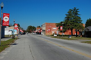
McColl is a town in Marlboro County, South Carolina, United States. It lies in the state's Pee Dee region, 8 miles (13 km) from the North Carolina border. The population was 2,174 at the 2010 census.

The Pee Dee people, also Pedee and Peedee, are American Indians of the Southeast United States. Historically, their population has been concentrated in the Piedmont of present-day South Carolina. In the 17th and 18th centuries, English colonists named the Pee Dee River and the Pee Dee region of South Carolina for the tribe.

The Lumber River, sometimes referred to as the Lumbee River, is a 133-mile-long (214 km) river in south-central North Carolina in the flat Coastal Plain. European settlers first called the river Drowning Creek, which is still used as the name of its headwater. The waterway known as the Lumber River extends downstream from the Scotland County-Hoke County border to the North Carolina-South Carolina border. Soon after crossing into South Carolina, the Lumber River flows into the Little Pee Dee River, which flows into the Pee Dee River, or Great Pee Dee River. Finally, the combined waters flow into Winyah Bay and the Atlantic Ocean.

Town Creek Indian Mound is a prehistoric Native American archaeological site located near present-day Mount Gilead, Montgomery County, North Carolina, in the United States. The site, whose main features are a platform mound with a surrounding village and wooden defensive palisade, was built by the Pee Dee, a South Appalachian Mississippian culture people that developed in the region as early as 980 CE. They thrived in the Pee Dee River region of North and South Carolina during the Pre-Columbian era. The Town Creek site was an important ceremonial site occupied from about 1150—1400 CE. It was abandoned for unknown reasons. It is the only ceremonial mound and village center of the Pee Dee located within North Carolina.
Snow's Island is an area of swampy lowlands along the Pee Dee River in Florence County, South Carolina. The area is historically significant as the headquarters during the American Revolutionary War for forces led by Francis Marion (1732-1795), a South Carolina militia officer who is celebrated as the "Swamp Fox." Employing guerrilla war tactics, Marion significantly contributed to the American war effort by conducting numerous raids on British outposts." The site was declared a National Historic Landmark in 1974.

The Yadkin–Pee Dee River Basin is a large river basin in the eastern United States, covering around 7,221 square miles, making it the second largest in the state of North Carolina. Its headwaters rise near Blowing Rock, North Carolina, and the basin drains to the Atlantic Ocean in Winyah Bay, east of Georgetown, South Carolina.

Prince Frederick's Chapel Ruins is a historic site in Plantersville, South Carolina.
Welsh Neck–Long Bluff–Society Hill Historic District is a national historic district located near Bennettsville, Marlboro County, South Carolina. The district encompasses 250 contributing buildings in the communities of Welsh Neck, Long Bluff, and Society Hill. The Welsh Neck community was an early religious center for the Pee Dee region, and Long Bluff served as a judicial center. The courthouse at Long Bluff, with its jail, tavern, and supporting buildings, was a center of activity for the Upper Pee Dee region during the Revolution. Few small communities have contributed more to the public in the way of culture, education and leadership than has Society Hill. It has numbered among its population outstanding leaders in religion and education, jurists, statesmen, soldiers, authors, and agriculturists. The Society Hill Library Society was formed in 1822. This group grew out of the St. David's Society, founded 1777 in Cheraw, which had a widespread influence and was a main factor in making Society Hill a center of intelligent leadership in the Pee Dee for a century and a half.
Pee Dee River Rice Planters Historic District is a set of historic rice plantation properties and national historic district located near Georgetown, Georgetown County, South Carolina.
The Adamson Mounds Site (38KE11) is an archaeological site located near Camden, Kershaw County, South Carolina. It is a prehistoric Native American village site containing one large platform mound, a smaller mound, possibly a third still smaller mound, and a burial area. It served as a regional ceremonial center. This site represents a widespread, late prehistoric Mississippian culture known by the names of Lamar, Irene, or Pee Dee and dates probably between AD 1400 and AD 1700.
The McDowell Site, also known as Chesnut Mounds, Taylor Mounds, and Mulberry Plantation House, is a set of historic mounds located near Camden, Kershaw County, South Carolina. The McDowell Site is among the first archaeological sites to be carefully excavated and archaeologically reported in the United States. It represents a widespread late prehistoric Indian culture known by the names of Lamar, Irene, and Pee Dee, and possibly extends into protohistoric and historic times. It probably dates between AD 1400 and AD 1700.
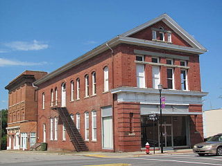
Bank of Pee Dee Building is a historic bank building located at 201 East Washington Street in Rockingham, Richmond County, North Carolina. It was built in 1904–1905, and is a two-story, red brick early commercial style building. It has a pedimented front gable roof

Pee Dee Avenue Historic District is a national historic district located at Albemarle, Stanly County, North Carolina. The district encompasses 87 contributing buildings and 1 contributing site in a predominantly residential section of Albemarle. They were built between about 1891 and 1947 and include notable examples of Queen Anne, Colonial Revival, and Bungalow / American Craftsman style residential architecture. Notable buildings include the Brown-Parker House, Crowell House, Lambert-Hughes-Ferrell House, W. Berly Beaver House (1929-1936), David Augustus Holbrook House (1929-1936), Langley-Holbrook House, William Thomas Huckabee, Jr., House (1947), Robert Lee Smith Family House, and Wade F. Denning House.

Washington Magnet Elementary School is a historic school and building located at Raleigh, Wake County, North Carolina. It was built in 1923-1924 to serve African-American students in Raleigh and is now a magnet elementary school.
References
- 1 2 "National Register Information System". National Register of Historic Places . National Park Service. July 9, 2010.
- ↑ Mountjoy, Joseph (1989). "Early Radiocarbon Dates from a Site on the Pee Dee-Siouan Frontier in the Piedmont of Central North Carolina" (PDF). Southern Indian Studies (Volume 38). Retrieved September 5, 2015.
| Topics | |
|---|---|
| Lists by state |
|
| Lists by insular areas | |
| Lists by associated state | |
| Other areas | |
| Related | |