Hopwood is a census-designated place (CDP) in Fayette County, Pennsylvania, United States. The population was 2,090 at the 2010 census, up from 2,006 at the 2000 census. It is located in North Union and South Union townships. The village was named after John Hopwood.

This is a list of sites in Minnesota which are included in the National Register of Historic Places. There are more than 1,700 properties and historic districts listed on the NRHP; each of Minnesota's 87 counties has at least 2 listings. Twenty-two sites are also National Historic Landmarks.

John Hopwood Mickey was an American banker and Republican politician who served as the 13th Governor of Nebraska from 1903 to 1907.

The Green–Meldrim House is a historic house at 14 West Macon Street, on the northwest corner of Madison Square, in Savannah, Georgia. Built in 1853, it was designated as a National Historic Landmark in 1976 as one of the American South's finest and most lavish examples of Gothic Revival architecture. The house is owned by the adjacent St. John's Episcopal Church, which offers tours and uses it as a meeting and reception space.

The Andrew John Volstead House is the historic house in Granite Falls, Minnesota, of ten-term United States Congressman Andrew Volstead (1860–1947). It is now managed as a museum and the organizational headquarters of the Granite Falls Historical Society. Volstead became nationally synonymous with Prohibition in 1919 when, as chairman of the House Judiciary Committee, he was obliged to author the Volstead Act, enabling enforcement of the recently ratified Eighteenth Amendment. Volstead was a moderate progressive who coauthored the Capper–Volstead Act in 1922, which legalized agricultural cooperatives.

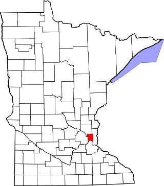
This is a list of the National Register of Historic Places listings in Dakota County, Minnesota. It is intended to be a complete list of the properties and districts on the National Register of Historic Places in Dakota County, Minnesota, United States. Dakota County is located in the southeastern part of the U.S. state of Minnesota, bounded on the northeast side by the Upper Mississippi River and on the northwest by the Minnesota River. The locations of National Register properties and districts for which the latitude and longitude coordinates are included below, may be seen in an online map.

This list is of the properties and historic districts which are designated on the National Register of Historic Places or that were formerly so designated, in Hennepin County, Minnesota; there are 190 entries as of April 2023. A significant number of these properties are a result of the establishment of Fort Snelling, the development of water power at Saint Anthony Falls, and the thriving city of Minneapolis that developed around the falls. Many historic sites outside the Minneapolis city limits are associated with pioneers who established missions, farms, and schools in areas that are now suburbs in that metropolitan area.

The John Rider House is located on Main Street in Danbury, Connecticut, United States. It is a wooden frame house dating to the late 18th century.
This is a complete list of National Register of Historic Places listings in Ramsey County, Minnesota. It is intended to be a complete list of the properties and districts on the National Register of Historic Places in Ramsey County, Minnesota, United States. The locations of National Register properties and districts for which the latitude and longitude coordinates are included below, may be seen in an online map.

This is a list of the National Register of Historic Places listings in Rice County, Minnesota. It is intended to be a complete list of the properties and districts on the National Register of Historic Places in Rice County, Minnesota, United States. The locations of National Register properties and districts for which the latitude and longitude coordinates are included below, may be seen in an online map.

This is a list of the National Register of Historic Places listings in Chisago County, Minnesota. It is intended to be a complete list of the properties and districts on the National Register of Historic Places in Chisago County, Minnesota, United States. The locations of National Register properties and districts for which the latitude and longitude coordinates are included below, may be seen in an online map.

This is a list of the National Register of Historic Places listings in Winona County, Minnesota. It is intended to be a complete list of the properties and districts on the National Register of Historic Places in Winona County, Minnesota, United States. The locations of National Register properties and districts for which the latitude and longitude coordinates are included below, may be seen in an online map.

This is a list of the National Register of Historic Places listings in Washington County, Minnesota. It is intended to be a complete list of the properties and districts on the National Register of Historic Places in Washington County, Minnesota, United States. The locations of National Register properties and districts for which the latitude and longitude coordinates are included below, may be seen in an online map.

This is a list of the National Register of Historic Places listings in Wright County, Minnesota. It is intended to be a complete list of the properties and districts on the National Register of Historic Places in Wright County, Minnesota, United States. The locations of National Register properties and districts for which the latitude and longitude coordinates are included below, may be seen in an online map.
This is a list of the National Register of Historic Places listings in Houston County, Minnesota. It is intended to be a complete list of the properties and districts on the National Register of Historic Places in Houston County, Minnesota, United States. The locations of National Register properties and districts for which the latitude and longitude coordinates are included below, may be seen in an online map.

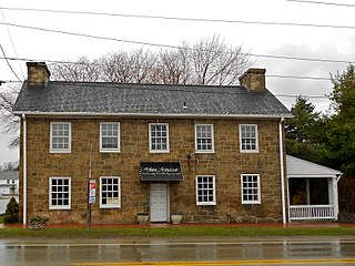
Brooklandville House, or the Valley Inn, is a historic restaurant and tavern building, and a former inn, located in Brooklandville, Baltimore County, Maryland. It is a 2+1⁄2-story stone structure facing the former railroad and dating from about 1832. It is associated with the Baltimore and Susquehanna Railroad, which crossed the property just to the south.

This is a list of the National Register of Historic Places listings in Faribault County, Minnesota. This is intended to be a complete list of the properties and districts on the National Register of Historic Places in Faribault County, Minnesota, United States. The locations of National Register properties and districts for which the latitude and longitude coordinates are included below, may be seen in an online map.

This is a list of the National Register of Historic Places listings in Meeker County, Minnesota.
This is a list of the properties and historic districts in Stamford, Connecticut that are listed on the National Register of Historic Places. The locations of National Register properties and districts for which the latitude and longitude coordinates are included below, may be seen in an online map.

This is a list of the National Register of Historic Places listings in Polk County, Wisconsin. It is intended to provide a comprehensive listing of entries in the National Register of Historic Places that are located in Polk County, Wisconsin. The locations of National Register properties for which the latitude and longitude coordinates are included below may be seen in a map.


