
Starved Rock State Park is a state park in the U.S. state of Illinois, characterized by the many canyons within its 2,630 acres (1,064 ha). Located just southeast of the village of Utica, in Deer Park Township, LaSalle County, Illinois, along the south bank of the Illinois River, the park hosts over two million visitors annually, the most for any Illinois state park.

Fort Ouiatenon, built in 1717, was the first fortified European settlement in what is now Indiana, United States. It was a palisade stockade with log blockhouse used as a French trading post on the Wabash River located approximately three miles southwest of modern-day West Lafayette. The name 'Ouiatenon' is a French rendering of the name in the Wea language, waayaahtanonki, meaning 'place of the whirlpool'. It was one of three French forts built during the 18th century in what was then New France, later the Northwest Territory and today the state of Indiana, the other two being Fort Miami and Fort Vincennes. A substantial French settlement grew up around the fort in the mid-18th century. It was ceded to the British and abandoned after the French and Indian war. Later, it passed into Indian hands and was destroyed in 1791 by American militia during the Northwest Indian War. It was never a U.S. fort. The original site was rediscovered in the 1960s; the archaeological site was listed on the National Register of Historic Places in 1970, and was designated a National Historic Landmark in 2021.

This is a list of properties and districts in Illinois that are on the National Register of Historic Places. There are over 1,900 in total. Of these, 85 are National Historic Landmarks. There are listings in all of the state's 102 counties.
This National Park Service list is complete through NPS recent listings posted July 28, 2023.
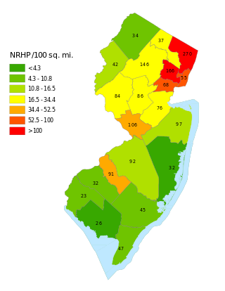
This is a list of properties and districts listed on the National Register of Historic Places in New Jersey. There are more than 1,700 listed sites in New Jersey. Of these, 58 are further designated as National Historic Landmarks. All 21 counties in New Jersey have listings on the National Register.
This National Park Service list is complete through NPS recent listings posted August 4, 2023.
The Kamp Mound Site is a prehistoric mound and village site located along the Illinois River and Illinois Route 100 north of Kampsville, Illinois. The Hopewellian site includes seven mounds dating from 100 B.C. - 450 A.D. and a village site dating from 450 to 700 A.D. The Havana Hopewell culture used the complex as a ceremonial and burial site. Archaeologists have also proposed that the site served as a regional trade center for the Hopewellian exchange system. The seven mounds at the site, which were originally part of a group of ten, include some of Illinois' largest mounds. In addition, large amounts of shell and animal bone fragments have been recovered from the site.
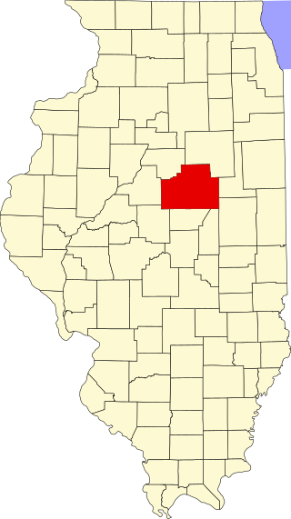
This is a list of the National Register of Historic Places listings in McLean County, Illinois.

The Old Stone Hotel, also known as the Warren Community Building or Warren House Hotel, was constructed in 1851 as a stagecoach station. It was located closely to the crossing of two stagecoach routes near the Illinois-Wisconsin border in the village of Warren, Illinois, United States. The building was added to the U.S. National Register of Historic Places in 1975.

This is a list of the National Register of Historic Places listings in Whiteside County, Illinois.

This is a list of the National Register of Historic Places listings in LaSalle County, Illinois.
This is a list of the National Register of Historic Places listings in St. Clair County, Illinois.
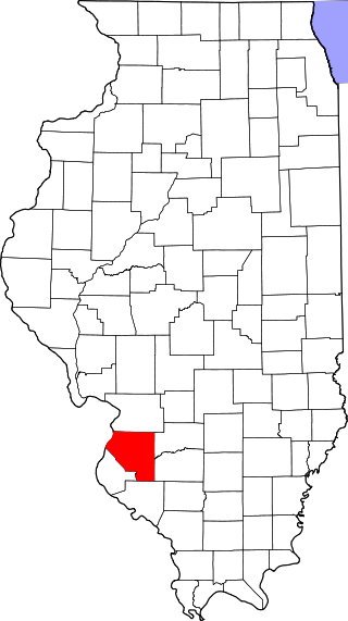
This is a list of the National Register of Historic Places listings in Jackson County, Illinois.
This is a list of the National Register of Historic Places listings in White County, Illinois.

This is a list of the National Register of Historic Places listings in Warren County, Illinois.
The Ware Mounds and Village Site (11U31), also known as the Running Lake Site, located west of Ware, Illinois, is an archaeological site comprising three platform mounds and a 160-acre (65 ha) village site. The site was inhabited by the Late Woodland and Mississippian cultures from c. 800 to c. 1300. The village is one of the only Mississippian villages known to have existed in the Mississippi River valley in Southern Illinois. As the village was located near two major sources of chert, which Mississippian cultures used to make agricultural tools, it was likely a trading center for the mineral.

Dogtooth Bend Mounds and Village Site is an archaeological site located on the western shore of Lake Milligan in Alexander County, Illinois. The site includes two mounds and a village site stretching northwest of the mounds. The village was inhabited by Middle Mississippian peoples from roughly 900-1600 A.D. It likely served as a trade hub and a social center for residents of the surrounding farmland. Formal archaeological investigation of the site was initiated in 1950 by Irvin Peithman of Southern Illinois University.
The Orr-Herl Mound and Village Site is an archaeological site located along the Ohio River in Hardin County, Illinois, United States. The site consists of a mound, which includes a sizable midden, and the remains of a village. The village was inhabited from roughly 900 to 1500 AD by Mississippian peoples. The site was an important source of fluorspar, which Mississippian peoples used for carvings and beads. The village was likely a manufacturing site for fluorspar items, which were then traded to other villages; this theory is supported by fluorspar artifacts recovered from the Kincaid Site, a Mississippian chiefdom center on the Ohio River in Illinois.

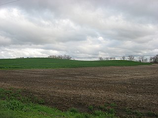
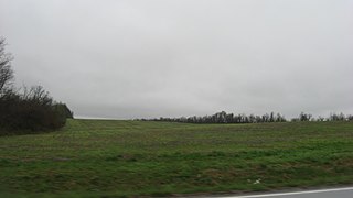
The Wilson Mounds and Village Site is a prehistoric archaeological site located in and around the Marshall Ferry Cemetery in Rising Sun, White County, Illinois. The site includes twelve Hopewell burial mounds and a village site.

The Lunsford-Pulcher Archeological Site is a prehistoric archaeological site in rural Monroe and St. Clair counties in Illinois. The site was the location of a Middle Mississippian village which was probably a satellite community of Cahokia. Several pyramidal burial mounds are included in the site. Archaeological excavations at the site have also discovered the remains of houses and garden beds, making the site one of the few Mississippian villages at which garden beds have been found. The site has been known to European settlers since early settlement of the area in the late 18th century; despite being used for farmland, the site remains in good condition.

The Emerald Mound and Village Site is a pre-Columbian archaeological site located northwest of the junction of Emerald Mound Grange and Midgley Neiss Roads in St. Clair County, Illinois. The site includes five mounds, two of which have been destroyed by modern activity, and the remains of a village. Middle Mississippian peoples inhabited the village, which was a satellite village of Cahokia. The largest of the mounds is a two-tiered structure that stands 50 feet (15 m) high; its square base is 300 feet (91 m) across, while its upper tier is 150 feet (46 m) across. At the time of its discovery, the mound was the second-largest known in Illinois after Monks Mound at Cahokia.


