
Los Angeles International Airport, commonly referred to as LAX, is the primary international airport serving Los Angeles, California and its surrounding metropolitan area. LAX is located in the Westchester neighborhood of Los Angeles, 18 miles (30 km) southwest of Downtown Los Angeles, with the commercial and residential areas of Westchester to the north, the city of El Segundo to the south and the city of Inglewood to the east. LAX is the closest airport to the Westside and the South Bay.

Grants is a city in Cibola County, New Mexico, United States. It is located about 78 miles (126 km) west of Albuquerque. The population was 9,163 at the 2020 Census. It is the county seat of Cibola County.

Western Airlines was a major airline based in California, operating in the Western United States including Alaska and Hawaii, and western Canada, as well as to New York City, Boston, Washington, D.C., and Miami and to Mexico City, London and Nassau. Western had hubs at Los Angeles International Airport, Salt Lake City International Airport, and the former Stapleton International Airport in Denver. Before it merged with Delta Air Lines in 1987 it was headquartered at Los Angeles International Airport (LAX). Throughout the company's history, its slogan was "Western Airlines...The Only Way to Fly!"
John Wayne Airport is a commercial and general aviation airport that serves Orange County, California, and the Greater Los Angeles area. The airport is located in an unincorporated area of Orange County, and it is owned and operated by the county. John Wayne Airport is surrounded by the cities of Irvine, Newport Beach, and Costa Mesa, although its IATA airport code and mailing address are both registered to Santa Ana, the county seat. Originally named Orange County Airport, the Orange County Board of Supervisors renamed the airport in 1979 in honor of actor John Wayne, who lived in neighboring Newport Beach and died that year. A statue of John Wayne was installed at the airline terminal in 1982.

Hollywood Burbank Airport, legally and formerly marketed as Bob Hope Airport after entertainer Bob Hope, is a public airport three miles (4.8 km) northwest of downtown Burbank, in Los Angeles County, California, United States. The airport serves Burbank, Hollywood, and the northern Greater Los Angeles area, which includes Glendale, Pasadena, the San Fernando Valley and the Santa Clarita Valley. It is closer to many popular attractions, including Griffith Park, Universal Studios Hollywood, and Downtown Los Angeles, than Los Angeles International Airport (LAX), and it is the only airport in the area with a direct rail connection to Downtown Los Angeles, with service from two stations: Burbank Airport–North and Burbank Airport–South. Nonstop flights mostly serve cities in the western United States, though JetBlue has daily flights to New York City. Southwest also occasionally flies non regular routes to the East Coast.

Eugene Airport, also known as Mahlon Sweet Field, is a public airport 7 miles (11 km) northwest of Eugene, in Lane County, Oregon, United States. Owned and operated by the City of Eugene, it is the fifth-largest airport in the Pacific Northwest.
El Paso International Airport is four miles (6 km) northeast of downtown El Paso, in El Paso County, Texas, United States. It is the busiest commercial airport in West Texas, Southern New Mexico and Northern Mexico. It handled 3,667,439 passengers in 2022, with 83,438 cargo operations.
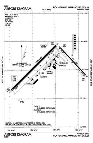
Rick Husband Amarillo International Airport is a public airport six miles (10 km) east of downtown Amarillo, in Potter County, Texas, United States. The airport was renamed in 2003 after NASA astronaut and Amarillo native Rick Husband, who died in the Space Shuttle Columbia disaster in February of that year.

Lubbock Preston Smith International Airport is five miles north of Lubbock, in Lubbock County, Texas, United States. Originally Lubbock International Airport, it was renamed in 2004 for former Texas governor Preston E. Smith, an alumnus of Texas Tech University.

Canadian Pacific Air Lines was a Canadian airline that operated from 1942 to 1987. It operated under the name CP Air from 1968 to 1986. Headquartered at Vancouver International Airport in Richmond, British Columbia, it served domestic Canadian as well as international routes until it was purchased by Pacific Western Airlines and absorbed into Canadian Airlines International.

Palmdale Regional Airport is an airport in Palmdale, California, United States. The city of Palmdale took over the airport at the end of 2013, managing it via the Palmdale Airport Authority. The airport currently does not have any scheduled passenger airline service.

Roswell Air Center is an airport five miles (8.0 km) south of Roswell, in Chaves County, New Mexico, United States.

Santa Fe Regional Airport is a public use airport in Santa Fe, Santa Fe County, New Mexico, United States, 10 miles (16 km) southwest of the city center. The airport serves the greater Santa Fe and Los Alamos areas.
Yuma International Airport is a joint use airport with civilian and military flight activity operated in conjunction with the U.S. Marine Corps via the Marine Corps Air Station Yuma. The airfield is located 3.5 miles south of the central business district of Yuma, a city in Yuma County, Arizona, United States, and 150 miles east of San Diego International Airport. It is mostly used for military aviation, but is also served by one commercial airline and one aeromedical Medevac company as well as being used for general aviation activities.

West Mesa Airport, also known as Western Air Express Airport, TWA Airport, or Cutter-Carr Airport, was an airport on the West Side of Albuquerque, New Mexico, United States, which was the city's main commercial aviation facility during the 1930s. It was built in 1929 by Western Air Express as a stop on the airline's Los Angeles–Kansas City route, with a hangar and passenger terminal added in 1930. It was the city's second airfield after the original Albuquerque Airport, which was used by a rival airline, Transcontinental Air Transport (TAT). The two airlines merged in 1930 to form TWA, moving all of their operations to the West Mesa field. The merger gave TWA control of the nation's first coast-to-coast passenger airline route and allowed it to secure a lucrative federal airmail contract.
Transcontinental Air Transport (T-A-T) was an airline founded in 1928 by Clement Melville Keys that merged in 1930 with Western Air Express to form what became TWA. Keys enlisted the help of Charles Lindbergh to design a transcontinental network to get government airmail contracts. Lindbergh established numerous airports across the country in this effort.

An airway beacon (US) or aerial lighthouse was a rotating light assembly mounted atop a tower. These were once used extensively in the United States for visual navigation by airplane pilots along a specified airway corridor. In Europe, they were used to guide aircraft with lighted beacons at night.

Willows-Glenn County Airport is a county-owned, public-use airport located one nautical mile (2 km) west of the central business district of Willows, a city in Glenn County, California, United States. This airport is included in the National Plan of Integrated Airport Systems for 2011–2015, which categorized it as a general aviation facility. It is also known as Willows-Glenn Airport.

The Transcontinental Airway System was a navigational aid deployed in the United States during the 1920s.

