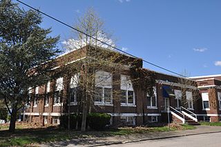
North Grosvenordale is a village and census-designated place (CDP) in the town of Thompson in Windham County, Connecticut, United States. The population was 1,530 at the 2010 census. The core of the village is listed as the North Grosvenordale Mill Historic District on the National Register of Historic Places. The historic area around the cotton mill was listed in 1993 and is located on Riverside Drive, Buckley Hill Road, Floral Avenue, Market Lane, and Marshall, Central, River, and Holmes Streets.

West Warwick is a town in Kent County, Rhode Island, United States. The population was 31,012 at the 2020 census.

Slatersville is a village on the Branch River in the town of North Smithfield, Rhode Island, United States. It includes the Slatersville Historic District, a historic district listed on the National Register of Historic Places. The historic district has been included as part of the Blackstone River Valley National Historical Park. The North Smithfield Public Library is located in Slatersville.
Forestdale is a village and historic district in North Smithfield, Providence County, Rhode Island, United States, one-half mile from Slatersville, Rhode Island. The historic district runs east and west along Main Street and north on Maple Avenue. School Street is the primary road through the village, and the one-room schoolhouse for which the street is named still stands. The Branch River runs through the valley adjacent to the School Street. The Village Haven Restaurant and local VFW chapter are also located in the village.
Oakland is a village in Burrillville, Providence County, Rhode Island, United States. It was developed in the 19th century at the site of a stone mill near the confluence of the Chepachet and Clear Rivers. It is one of the few remaining stone mills in this state. Most of the village is included in the Oakland Historic District, a historic district listed on the National Register of Historic Places. Most of the housing in the village was originally built to house mill workers, although there are several more elaborate houses built for mill executives.
Lonsdale is a village and historic district in Lincoln and Cumberland, Providence County, Rhode Island, United States, near Rhode Island Route 146 and Route 95. The village was originally part of the town of Smithfield until Lincoln was created in the 1870s, and was originally centered on the Lincoln side of the Blackstone River. William Blaxton settled in the area in 1635. In the nineteenth and early twentieth centuries, Lonsdale was home to several manufacturers including the Lonsdale Company's Bleachery, and the Ann & Hope mill was also located in the village in Cumberland.

Saylesville is a village and historic district in Lincoln, Rhode Island.

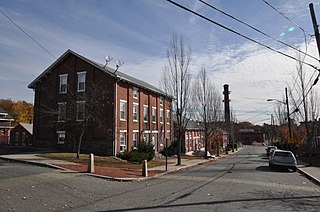
The Central Falls Mill Historic District is located between Roosevelt Avenue and the Blackstone River in Central Falls, Rhode Island. It encompasses a collection of six mill buildings, as well as a stone dam which impounds the river, representing the finest mill constructions in the city during the 19th century. The layout of the buildings, whose short ends face the river and Roosevelt Avenue, was defined by a series of trenches which channeled water from the river to power the machinery of the mills. The oldest building dates to 1825, and the most recent to c. 1910; all have been modified to some extent by later industrial tenants.

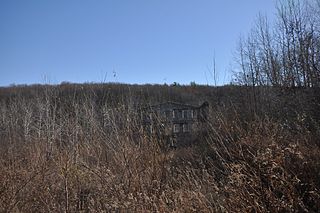
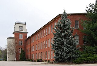
The Greystone Mill Historic District encompasses an early 20th-century textile mill complex on Greystone Avenue in Johnston and North Providence, Rhode Island. The complex consists of three brick buildings on the North Providence side of the Woonasquatucket River, a dam spanning the river, and a water tank near the dam in Johnston. The main structure consists of a series of structures combined to form a rambling structure, built between 1904 and 1911 to designs by Frank Sheldon and Son, an architectural firm that was a leading designer of textile facilities at the time.
The Richmond Paper Company Mill Complex is an historic American paper mill at 310 Bourne Avenue in East Providence, Rhode Island. It consists of a collection of mainly brick buildings on 13 acres (5.3 ha) of land, bounded on the north by Bourne Avenue, the east by railroad tracks, the west by the Seekonk River, and on the south by land formerly owned by the Washburn Wire Company. The first seven of the surviving buildings were built between 1883 and 1887 by the Richmond Paper Company. The property was acquired at auction in 1894 by Eugene Phillips, who operated the American Electrical Works on the premises, adding further buildings between 1900 and 1930 and demolishing several buildings specific to paper processing. The property presently sees a variety of light industrial uses. The Richmond Paper Company is notable as the place where Arthur Dehon Little started his career.

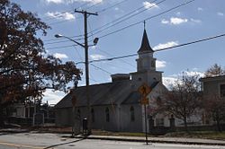
The Wanskuck Historic District is a historic district in the city of Providence, Rhode Island encompassing a mill village with more than two hundred years of history. As early as the mid-18th century, mills stood on the West River in northern Providence, a development which continued with the rise of industrialization in the 19th century. The mill village of Wanskuck is organized around three thoroughfares: Branch Street, Veazie Street, and Woodward Road, and is roughly bounded on the east by Louisquisset Pike and to the northwest by the city line with North Providence. The West River runs through the district, with its banks lined by two late-19th-century mill complexes. The village area includes a variety of examples of mill worker housing, from duplexes to rowhouses, as well as two church complexes and a community hall built in 1884 by the Wanskuck Company.

The Hamilton Mill Village Historic District is a historic district encompassing a small mill village in North Kingstown, Rhode Island. It is located on the south side of the Annaquatucket River, near its mouth at Bissell Cove. The village includes two wood-frame mill buildings and a collection of mill worker housing units, which line a short section of Boston Neck Road as well as Salisbury Avenue, Web Avenue, and Martha Road. The most impressive mill building is the main mill, built in 1853 and enlarged in 1866 with a double clerestory roof, something not found in other surviving mills in the state.

The Hope Village Historic District is a historic rural mill settlement within Hope Village in Scituate, Rhode Island. Hope Village is located on a bend in the North Pawtuxet River in the southeastern corner of Scituate. Industrial activity has occurred in Hope Village since the mid-eighteenth century. Surviving industrial and residential buildings in the Historic District date back to the early 19th century. The village center sits at junction of Main Street and North Road. Hope Village radiates out from the center with houses on several smaller side streets in a compact configuration. Currently there is little commercial or industrial activity in Hope Village and none in the Historic District. The present stone mill building on the south side of Hope Village was built in 1844 by Brown & Ives of Providence, expanded in 1871 and modified in 1910. Approximately one quarter of the village's current housing stock was built as mill worker housing by various owners of Hope Mill.
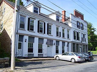
Lafayette Village is a historic district extending along Ten Rod Road in North Kingstown, Rhode Island. It encompasses a linear rural and industrial village, running from the Wickford Junction railroad crossing in the west to Angel Avenue in the east, and includes a number of residential properties on adjacent side streets. The centerpiece of the district is the Rodman Manufacturing Company complex, which operated here for a century beginning in the 1840s. The Robert Rodman Mansion, a Second Empire house with an elaborate porch, stands at 731 Ten Rod Road, and the Walter Rodman House, built in the 1870s, is even more elaborately decorated. Most of the residential stock in the district is mill-related housing built by the Rodmans for their workers.

Wyoming is a village and census-designated place on the Wood River in southern Rhode Island, primarily in the town of Richmond, Rhode Island, but extending north across the river into the town of Hopkinton, Rhode Island. The population was 270 at the 2010 census. It is the site of the Wyoming Village Historic District and a post office assigned ZIP code 02898.

The Blackstone Manufacturing Company Historic District encompasses the "New City" or "High Rocks" area of Blackstone, Massachusetts, an industrial village associated with the Blackstone Manufacturing Company, which began operations in 1809. It includes an area roughly surrounding Butler, Canal, Church, County, Ives, Main, Mendon, Old Mendon, and School Streets. The district includes a wide variety of worker housing, as well as a granite storehouse, the only surviving company structure. The district was added to the National Register of Historic Places in 1995.

The Manville Company Worker Housing Historic District is a residential historic district encompassing an area of mill worker housing in the Manville village of Lincoln, Rhode Island. The district covers about 50 acres (20 ha) of the village, including properties on Angle, Main, Old Main, Spring, Summer, Winter, and Chestnut Streets, as well as several properties on adjoining roads, describing a crescent, part of which abuts the south bank of the Blackstone River. The housing in this district was built between about 1812 and 1890 by the various proprietors of the Manville Company, and feature a diversity of architectural styles, most of which are simple vernacular interpretations of styles popular at the time. Most of the houses are either 1-1/2 or 2-1/2 stories in height, with one or two units per structure, and are set on small lots. There are also a series of brick rowhouses, a relative rarity in Rhode Island mill housing of the period.

The Phillipsdale Historic District encompasses a historic mill village along the Seekonk River in East Providence, Rhode Island. The village grew up around the Richmond Paper Company Mill Complex, built 1883-1887, which is separately listed on the National Register. It also includes 75 units of worker housing, as well as five houses that predate the mill complex's construction. The Phillipsdale area was the largest source of employment in East Providence between 1893 and 1910. The district is centered on Roger Williams Avenue and Bourne Avenue, and includes properties on Ruth Avenue and the grid of roads between Ruth and Roger Williams. It also includes Omega Pond and the Omega Pond Railroad Bridge.
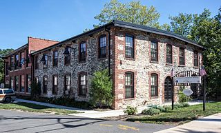
The Heaton and Cowing Mill is a historic industrial facility at 1115 Douglas Avenue in Providence, Rhode Island. The small mill complex consists of three connected building sections; the oldest is a c. 1832 rubble-walled two story mill building constructed by David Heaton and Martin Cowing on the banks of the West River. The partners used the facility to manufacture and dye cotton cloth. The building is the remnant of a much larger Geneva Worsted Company works that Heaton and Cowing built on the site in the 1860s and 1870s.

Blackstone River Valley National Historical Park is a National Park Service unit in the states of Rhode Island and Massachusetts. The park was created for the purpose of preserving, protecting, and interpreting the industrial heritage of the Blackstone River Valley and the urban, rural, and agricultural landscape of that region. The Blackstone River Valley was the site of some of the earliest successful textile mills in the United States, and these mills contributed significantly to the earliest American Industrial Revolution. The subsequent construction of the Blackstone Canal, a few years after the successful completion of the Erie Canal, helped to sustain the region's industrial strength.