History
Originally chartered in 1853 as the Town of Lima, Harrison transitioned to become the Town of Harrison in 1858. Since its establishment, Harrison has grown into a thriving community, characterized by its rich history and natural beauty.
The first town meeting took place on the "Pratt farm" south of Sherwood, marking the beginning of Harrison's development. In 2013, the residents of the Town voted to incorporate Harrison into the Village of Harrison, a move certified by Secretary of State Douglas LaFollette on March 8, 2013. Following the incorporation, the Village of Harrison and the Town of Harrison entered into a boundary agreement, reunifying the community under one entity. The incorporation of Harrison into a village marked a significant shift, with some residents resenting the transition from a predominantly rural community to a more suburban one.
The Harrison Athletic Association (HAA) provides recreational opportunities and fosters community engagement through organized sports leagues and events.

Winnebago County is a county in the U.S. state of Wisconsin. As of the 2020 census, the population was 171,730. Its county seat is Oshkosh. It was named for the historic Winnebago people, a federally recognized Native American tribe now known as the Ho-Chunk Nation. Chief Oshkosh was a Menominee leader in the area. Winnebago County comprises the Oshkosh-Neenah, WI Metropolitan Statistical Area, which is included in the Appleton-Oshkosh-Neenah, WI Combined Statistical Area.

Outagamie County is a county in the Fox Cities region of the U.S. state of Wisconsin, located in the northeast of the state. As of the 2020 Census, the population was 190,705. Its county seat is Appleton.

Calumet County is a county located in the U.S. state of Wisconsin. As of the 2020 census, the population was 52,442. The county seat is Chilton. The county was created in 1836 and organized in 1850.

Brown County is a county in the U.S. state of Wisconsin. As of the 2020 census, the population was 268,740, making it the fourth-most populous county in Wisconsin. The county seat is Green Bay. Brown County is part of the Green Bay, WI Metropolitan Statistical Area.

Harrison is a town in Calumet County in the U.S. state of Wisconsin. The population was 10,839 at the 2010 census and 3,471 in 2013 after the incorporation of the Village of Harrison. After continued annexations, the Town of Harrison now consists of 6.2 acres of unpopulated land located off of Oneida Street, which is owned by the City of Menasha. The Village of Harrison and Town of Buchanan are collectively known locally as Darboy. Harrison was originally known as Lima.

Bear Creek is a village in Outagamie County, Wisconsin, United States. The population was 448 at the 2010 census.

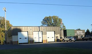
Buchanan is a town in Outagamie County, Wisconsin, United States. The population was 6,755 at the 2010 census. The unincorporated community of Darboy is located in the town.

Hortonville is a village in Outagamie County, Wisconsin, United States. The population was 2,711 at the 2010 census.

Shiocton is a village in Outagamie County, Wisconsin, United States. The population was 921 at the 2010 census. It is wholly surrounded by the Town of Bovina.

Menasha was a town in Winnebago County, Wisconsin, United States, west of the Fox River across from the city of Menasha, Wisconsin. The population was 18,498 at the 2010 census, making it the second most populous town in the state of Wisconsin at the time of its dissolution. The unincorporated community of Waverly Beach was located partially in the town. In an April 2016 referendum, the portion of the town west of Little Lake Butte des Morts voted to become the village of Fox Crossing. The remaining portions of the town were annexed to Fox Crossing on September 22, 2016, effectively ending the existence of the town.

Menasha is a city in Calumet and Winnebago counties in the U.S. state of Wisconsin. The population was 18,268 at the 2020 census. Of this, 15,144 were in Winnebago County, and 2,209 were in Calumet County. The city is located mostly in Winnebago County; only a small portion is in the Town of Harrison in Calumet County. Doty Island is located partially in Menasha. The city's name comes from the Winnebago word meaning "thorn" or "island". In the Menominee language, it is known as Menāēhsaeh, meaning "little island".

Stockbridge is a town in Calumet County, Wisconsin. The population was 1,456 at the time of the 2010 census. The village of Stockbridge, and the unincorporated communities of Kloten, Quinney, and Saint Catherines Bay are located within the town.

The Fox Cities of Northeastern Wisconsin are the cities, towns and villages along the Fox River as it flows from Lake Winnebago northward into Green Bay.
An urban town is a proposed classification for towns in the state of Wisconsin, similar to the urban townships of Minnesota and Ohio. The concept, originally proposed in 2001, as AB501, limited the classification to towns with over 7,500 people. The proposal has gained support from such organizations as the Wisconsin Towns Association. The impetus that originally spawned the concept of urban towns was an effort to stem annexation of urbanized areas in unincorporated area by cities and villages across county lines. Obtaining "urban town" status effectively freezes the town's boundaries. While urban towns would have substantially greater zoning and regulatory rights than "rural towns", the status would not confer "incorporated" status on the municipality, freeing them from several responsibilities incumbent upon incorporated municipal governments, thus distinguishing them from the incorporated towns of Illinois.
Wisconsin's 6th congressional district is a congressional district of the United States House of Representatives in eastern Wisconsin. It is based in the rural, suburban and exurban communities between Madison, Milwaukee, and Green Bay. It also includes the village of River Hills in far northern Milwaukee County. The district is currently represented by Glenn Grothman (R-Glenbeaulah) who took office in January 2015.
Darboy is an unincorporated community in Outagamie County in the Fox Cities area of the U.S. state of Wisconsin. Located in the town of Buchanan, Darboy extends from the Calumet County line on the south, Highway CE on the north, State Park Road on the east, and Highway 441 on the west. Prior to 2013, Darboy extended south in Calumet County to Manitowoc Road in the town of Harrison; however, this part of Darboy became part of the village of Harrison upon its incorporation.

Pipe, Wisconsin is an unincorporated community in the Town of Calumet in Fond du Lac County, Wisconsin, United States. It is located approximately 1 mile (1.6 km) east of Lake Winnebago.
Waverly Beach is an unincorporated community in the Town of Harrison, Calumet County, Wisconsin and Fox Crossing, Winnebago County, Wisconsin, United States. The Calumet County portion of Waverly Beach is located on the north shore of Lake Winnebago along U.S. Route 10 and the Canadian National Railway, 3.6 miles (5.8 km) south of downtown Appleton.
Fox Crossing is a village in Winnebago County, Wisconsin, United States. It was incorporated from the former town of Menasha in 2016. The population as of the 2020 census was 18,974.
The 3rd Assembly District of Wisconsin is one of 99 districts in the Wisconsin State Assembly. Located in northeast Wisconsin, the district comprises nearly all of Calumet County, and parts of western Manitowoc County. It includes the cities of Brillion, Chilton, and New Holstein, and the parts of Appleton and Menasha which fall within Calumet County. It also contains the villages of Hilbert, Potter, Sherwood, Stockbridge, St. Nazianz, Valders, and Whitelaw. The district is represented by Republican Ron Tusler, since January 2017.


