Harwood, Missouri

Last updated

Harwood, Missouri
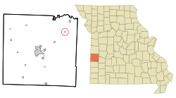
Vernon County Missouri Incorporated and Unincorporated areas Harwood Highlighted.svg
Location of Harwood, Missouri
Coordinates: 37°57′24″N94°09′14″W / 37.95667°N 94.15389°W / 37.95667; -94.15389
Country United States
State Missouri
County Vernon
Area
[1]
  Total0.10 sq mi (0.27 km2)
  Land0.10 sq mi (0.27 km2)
  Water0.00 sq mi (0.00 km2)
Elevation
[2]
837 ft (255 m)
Population
 (2020)
  Total29
  Density276.19/sq mi (106.54/km2)
Time zone UTC-6 (Central (CST))
  Summer (DST) UTC-5 (CDT)
ZIP code
64750
Area code 417
FIPS code 29-30862 [3]
GNIS feature ID2398263 [2]

Harwood is a village in northeast Vernon County, Missouri, United States. The population was 47 at the 2010 census. It was estimated to be 45 by the City of Harwood as of July 1, 2019. [4]

Contents

History

Harwood had its start when the railroad was extended to that point. [5] The town site was platted in 1882. [6] The village was named for one Mr. Harwood, a local landowner. [7] A post office has been in operation at Harwood since 1882. [8]

Geography

Harwood is located 13 miles northeast of Nevada and approximately 4.5 miles south-southeast of Schell City. [9]

According to the United States Census Bureau, the village has a total area of 0.11 square miles (0.28 km2), all land. [10]

Demographics

Historical population
CensusPop.Note
1890 240
1900 2400.0%
1910 208−13.3%
1920 2153.4%
1930 159−26.0%
1940 1675.0%
1950 141−15.6%
1960 89−36.9%
1970 912.2%
1980 10414.3%
1990 89−14.4%
2000 901.1%
2010 47−47.8%
2020 29−38.3%
U.S. Decennial Census [11]

2010 census

As of the census [12] of 2010, there were 47 people, 19 households, and 12 families living in the village. The population density was 427.3 inhabitants per square mile (165.0/km2). There were 34 housing units at an average density of 309.1 per square mile (119.3/km2). The racial makeup of the village was 95.7% White and 4.3% Native American.

There were 19 households, of which 21.1% had children under the age of 18 living with them, 42.1% were married couples living together, 21.1% had a female householder with no husband present, and 36.8% were non-families. 26.3% of all households were made up of individuals, and 10.6% had someone living alone who was 65 years of age or older. The average household size was 2.47 and the average family size was 3.17.

The median age in the village was 46.5 years. 21.3% of residents were under the age of 18; 6.4% were between the ages of 18 and 24; 19.2% were from 25 to 44; 38.3% were from 45 to 64; and 14.9% were 65 years of age or older. The gender makeup of the village was 42.6% male and 57.4% female.

2000 census

As of the census [3] of 2000, there were 90 people, 37 households, and 23 families living in the village. The population density was 874.4 inhabitants per square mile (337.6/km2). There were 45 housing units at an average density of 437.2 per square mile (168.8/km2). The racial makeup of the village was 92.22% White, 3.33% Native American, and 4.44% from two or more races.

There were 37 households, out of which 21.6% had children under the age of 18 living with them, 54.1% were married couples living together, 5.4% had a female householder with no husband present, and 37.8% were non-families. 29.7% of all households were made up of individuals, and 10.8% had someone living alone who was 65 years of age or older. The average household size was 2.43 and the average family size was 3.13.

In the village, the population was spread out, with 21.1% under the age of 18, 6.7% from 18 to 24, 20.0% from 25 to 44, 31.1% from 45 to 64, and 21.1% who were 65 years of age or older. The median age was 48 years. For every 100 females, there were 109.3 males. For every 100 females age 18 and over, there were 97.2 males.

The median income for a household in the village was $21,250, and the median income for a family was $26,250. Males had a median income of $21,146 versus $11,250 for females. The per capita income for the village was $11,028. There were 9.1% of families and 15.8% of the population living below the poverty line, including 20.0% of under eighteens and none of those over 64.
Related Research Articles

<span class="mw-page-title-main">St. Cloud, Missouri</span> Village in Missouri, United States

St. Cloud is a village in northeast Crawford County, Missouri, United States. The population was 41 at the 2010 census.

<span class="mw-page-title-main">Louisburg, Missouri</span> Village in Missouri, United States

Louisburg is a village in Dallas County, Missouri, United States. The population was 122 at the 2010 census. It is part of the Springfield, Missouri Metropolitan Statistical Area.

<span class="mw-page-title-main">Miramiguoa Park, Missouri</span> Village in Missouri, United States

Miramiguoa Park is a village in Franklin County, Missouri, United States. The population was 120 at the 2010 census.

<span class="mw-page-title-main">Fountain N' Lakes, Missouri</span> Village in Missouri, United States

Fountain N' Lakes is a village in Lincoln County, Missouri, United States. The population was 165 at the 2010 census.

<span class="mw-page-title-main">Truxton, Missouri</span> Village in Missouri, United States

Truxton is a village in Lincoln County, Missouri, United States. The population was 91 at the 2010 census.

<span class="mw-page-title-main">Pascola, Missouri</span> Village in Missouri, United States

Pascola is a village in Pemiscot County, Missouri, United States. The population was 108 at the 2010 census.

<span class="mw-page-title-main">Tarrants, Missouri</span> Village in Missouri, United States

Tarrants is a village in central Pike County, Missouri, United States. The population was 22 at the 2010 census.

<span class="mw-page-title-main">Grand Pass, Missouri</span> Village in Missouri, United States

Grand Pass is a village in Saline County, Missouri, United States. The population was 66 at the 2010 census.

<span class="mw-page-title-main">Roscoe, Missouri</span> Village in Missouri, United States

Roscoe is a village in St. Clair County, Missouri, United States. The population was 89 at the 2020 census.

<span class="mw-page-title-main">Country Life Acres, Missouri</span> Village in Missouri, United States

Country Life Acres is a village in St. Louis County, Missouri, United States. The population was 74 at the 2010 census.

<span class="mw-page-title-main">Glen Echo Park, Missouri</span> Village in Missouri, United States

Glen Echo Park is a village in St. Louis County, Missouri, United States. The population was 160 at the 2010 census. The community took its name from the Glen Echo Country Club.

<span class="mw-page-title-main">Mackenzie, Missouri</span> Village in Missouri, United States

Mackenzie is an unincorporated community in St. Louis County, Missouri, United States. The population was 134 at the 2010 census.

<span class="mw-page-title-main">Pasadena Park, Missouri</span> Village in Missouri, United States

Pasadena Park is a village in St. Louis County, Missouri, United States. The population was 470 at the 2010 census. It is part of the Normandy School District, and is distinct from the city of Pasadena Hills.

<span class="mw-page-title-main">Twin Oaks, Missouri</span> Village in Missouri, United States

Twin Oaks is a 4th class city in St. Louis County, Missouri, United States. The former Village of Twin Oaks changed its status to that of a city by public election in November 2016. The population was 392 at the 2010 census.

<span class="mw-page-title-main">Velda Village Hills, Missouri</span> City in Missouri, United States

Velda Village Hills is a city in northeastern St. Louis County, Missouri, United States. The population was 1,055 at the 2010 census.

<span class="mw-page-title-main">Westwood, Missouri</span> Village in Missouri, United States

Westwood is a village in west St. Louis County, Missouri, United States. The population was 316 at the 2020 census.

<span class="mw-page-title-main">Penermon, Missouri</span> Village in Missouri, United States

Penermon is a village in Stoddard County, Missouri, United States. The population was 64 at the 2010 census.

<span class="mw-page-title-main">Phillipsburg, Missouri</span> Village in Missouri, United States

Phillipsburg is a village in Laclede County, Missouri, United States. The population was 202 at the 2010 census.

<span class="mw-page-title-main">Champ, Missouri</span> Village in Missouri, United States

Champ is a village in St. Louis County, Missouri, United States. The population was 10 at the 2020 census.

<span class="mw-page-title-main">Uplands Park, Missouri</span> Village in Missouri, United States

Uplands Park is a village in St. Louis County, Missouri, United States. The population was 445 at the 2010 census. The village is one of many small majority black communities located in the Natural Bridge corridor of mid-St. Louis County, characterized by small homes on small lots.

References

  1. "ArcGIS REST Services Directory". United States Census Bureau. Retrieved August 28, 2022.
  2. 1 2 U.S. Geological Survey Geographic Names Information System: Harwood, Missouri
  3. 1 2 "U.S. Census website". United States Census Bureau . Retrieved January 31, 2008.
  4. Bureau, US Census. "Population and Housing Unit Estimates Tables". The United States Census Bureau. Retrieved July 22, 2020.
  5. "The Nevada Daily Mail". May 11, 1960. p. 8. Retrieved May 3, 2015.
  6. Eaton, David Wolfe (1918). How Missouri Counties, Towns and Streams Were Named. The State Historical Society of Missouri. p. 368.
  7. "Area towns approaching 100". The Nevada Daily Mail. August 14, 1970. p. 10. Retrieved October 28, 2015.
  8. "Vernon County". Jim Forte Postal History. Retrieved April 14, 2015.
  9. Missouri Atlas & Gazetteer, DeLorme, 1998, First edition, p. 42, ISBN   0-89933-224-2
  10. "US Gazetteer files 2010". United States Census Bureau . Retrieved July 8, 2012.
  11. "Census of Population and Housing". Census.gov. Retrieved June 4, 2015.
  12. "U.S. Census website". United States Census Bureau . Retrieved July 8, 2012.