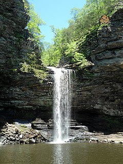
Petit Jean State Park is a 3,471-acre park in Conway County, Arkansas managed by the Arkansas Department of Parks and Tourism. It is located atop Petit Jean Mountain adjacent to the Arkansas River in the area between the Ouachita Mountains and Ozark Plateaus.
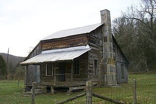
The Parker–Hickman Farm includes the oldest standing log structure in Buffalo National River. The farm was homesteaded in the 1840s by settlers from Tennessee. It embodies an agricultural landscape with farmstead, extant fields, fencerows, roads, cattle gates, garden and orchard plots, wooded slopes and springs. Unlike most farms in the Ozarks the landscape is remarkably intact and provides insights and evidence spanning portions of two centuries of Ozark history; not randomly chosen, it conveys a feeling of enclosure and exemplifies adaptive use of topography. Among farms of its kind in Missouri and Arkansas it was once typical but now survives as a rare baseline example for Ozark yeomanry farms of mixed economies. Parker–Hickman was an agricultural enterprise that continuously operated until 1982 from a farmstead which exemplifies the entire period, and a rare one for the Ozarks since it survives. Clustered around the farmstead are several structures: barns, sheds smokehouse, privy, fences, stock feeders and house that represent a cross-section of rural vernacular architecture still in their original location.

U.S. Route 64 is a U.S. highway running from Teec Nos Pos, Arizona east to Nags Head, North Carolina. In the U.S. state of Arkansas, the route runs 246.35 miles (396.46 km) from the Oklahoma border in Fort Smith east to the Tennessee border in Memphis. The route passes through several cities and towns, including Fort Smith, Clarksville, Russellville, Conway, Searcy, and West Memphis. US 64 runs parallel to Interstate 40 until Conway, when I-40 takes a more southerly route.

The Robert E. Campbell House is a historic house located in Springfield, Oregon. The architectural style reflects Rural Gothic style and it was built by early pioneer Robert E. Campbell about 1873. It was listed on the National Register of Historic Places on November 1, 1979.

U.S. Highway 71 is a U.S. highway that runs from Krotz Springs, LA to the Fort Frances–International Falls International Bridge at the Canadian border. In Arkansas, the highway runs from the Louisiana state line near Doddridge to the Missouri state line near Bella Vista. In Texarkana, the highway runs along State Line Avenue with US 59 and partially runs in Texas. Other areas served by the highway include Fort Smith and Northwest Arkansas.

The Capt. John T. Burkett House is a historic house in rural Ouachita County, Arkansas. It is located at 607 Ouachita County Road 65, near the community of Frenchport. The 1-1/2 story wood frame house was built c. 1899 by John Burkett, a ship's captain and part-owner of a local lumber mill. He later served as the chief warden at Cummins Prison, and then as a regional agent of the Internal Revenue Service. The house is a fine example of Folk Victorian style. Its front facade has a porch running across its whole width, mounted on piers made of locally manufactured bricks, with its hip-roof supported by concrete columns that resemble Tuscan-style columns. The balustrade is a metal filigree work. A gable-roof balcony projects above the center of the porch.
The Holt–Poindexter Store Building is a historic retail building in rural Ouachita County, Arkansas. It is located on County Road 101, near its southern junction with County Road 111, about 4 miles (6.4 km) north of Stephens, in the unincorporated community of Ogemaw. The store, a vernacular single-story wood frame structure with a gable roof and full-width front porch, was built in 1904 by H. B. Holt, and is believed to be the oldest general store in southern Arkansas. A small addition was added to the north side in the 1920s to house post office facilities. This was removed in 1948, at which time a rear addition was added to provide space for an office and feed storage. The business was taken over by Holt's son-in-law, Chester Poindexter, and then his son, Kenneth.
The SS Homer was a sidewheel paddle steamer which plied the waters of the Mississippi River and its tributaries. Built in 1859 in Parkersburg, West Virginia, she was 148 feet (45 m) long, 28 feet (8.5 m) wide, and 5 feet (1.5 m) deep. Her first significant service was in 1860, when she was used as a packet steamer on the Red and Ouachita Rivers, under master and co-owner Samuel Applegate. In 1861, after the start of the American Civil War, she was contracted to the government of the Confederate States of America, and was used to transport men and war materiel. She was used to supply the defenders of Port Hudson, Louisiana, in 1864. That year she was captured by the Union Army forces of General Frederick Steele when she was about 30 miles (48 km) below Camden, Arkansas on the Ouachita River. Steele was at the time engaged in a major expedition whose goal was to reach Shreveport, Louisiana, but had stalled due to Confederate resistance and a lack of supplies. Steele had then occupied Camden, and it was during this occupation that the ship was taken, loaded with grain and other supplies. The Union forces piloted her back to Camden.
The Leake–Ingham Building is a historic commercial building in Camden, Arkansas. It is located behind the McCollum-Chidester House at 926 Washington Street NW, and is part of the Ouachita County Historical Society Museum. It is one of the oldest commercial buildings in Camden. The single-story Greek Revival structure was built c. 1850 by William Leake, a prominent Camden attorney, and has a distinctive Greek temple front. It was originally located on a prominent corner of the city, at Washington and Harrison Streets. Leake operated a law practice from the building until 1866 with various partners, after which it was used to house government offices, and later Camden's first library. Threatened with demolition in the 1950s, it was moved several times before its acquisition by the historical society.

The Lester and Haltom No. 1 Well Site is the site of the first discovery of oil in the state of Arkansas in 1920. It is located in Ouachita County, about four miles (6.4 km) east of Stephens, and off Old Wire Road. The site is overgrown, with limited evidence of its past. There are, two large depressions in the ground, about 2 1⁄2 to 3 feet deep, and up to 75 feet (23 m) long and 35 feet (11 m) wide, one used as a mud pit, the other as a slush pit. A tar-blackened trail shows where there was runoff from the well, whose drill hole was just to the south of the mud pit. East of the mud pit is another depression where the steam engine was mounted; there is still a turnbuckle embedded in a nearby tree.
The Richmond-Tufts House is a historic house in rural Ouachita County, Arkansas, outside the county seat of Camden. This single-story wood frame house was built in 1859, and was originally located on West Washington Street in Camden, before being moved to its present location c. 1961. When first built, the house had Greek Revival styling, but it was extensively renovated and extended after its purchase in 1883 by Alfred Tufts, a Northern carpetbagger who moved to Camden after the American Civil War, married a local woman, and acquired a great deal of land. He made numerous Late Victorian additions to the house, most of which were undone when the house was moved, restoring its original Greek Revival character. The house is five bays wide, with a side gable roof, and a four-column porch that extends across a portion of the front.

The Rumph House is a historic house at 717 Washington Street in Camden, Arkansas. In 1874 a single-story Victorian house was built, in which Dr. Junius Bragg, a Confederate Army surgeon, lived for many years. This house was extensively remodeled in 1925, during Arkansas' oil boom, adding a second floor, and restyling the building in the then-popular Craftsman style. This renovation was undertaken by Garland S. Rumph, who was prominent in local politics. Its Craftsman features include wide eaves, stuccoed gable ends, and exposed false rafter beams.

The Bard Springs Dam No. 1 is a historic recreational support facility in Ouachita National Forest. It is located at the Bard Springs recreation site, southeast of Mena and north of Athens in Polk County, off County Road 82 and Forest Road 106 on the banks of Blaylock Creek. This dam is located at the western end of the recreation area, and is about 65 feet (20 m) long and 8 feet (2.4 m) high at its center. It is made of fieldstone, and has a series of chutes and steps across its top. It was built in 1936 by a crew of the Civilian Conservation Corps, and is one of four surviving CCC structures in the immediate area.

The Bard Springs Dam No. 2 is a historic recreational support facility in Ouachita National Forest. It is located at the Bard Springs recreation site, southeast of Mena and north of Athens in Polk County, off County Road 82 and Forest Road 106 on the banks of Blaylock Creek. This dam is located at the eastern end of the recreation area, and is about 75 feet (23 m) long and 15 feet (4.6 m) high at its center. It is made of fieldstone, and has a series of staggered steps at its base to reduce erosion. It was built in 1936 by a crew of the Civilian Conservation Corps, and is one of four surviving CCC structures in the immediate area.
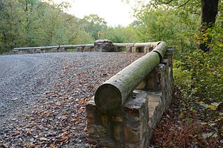
The Buckeye Vista Overlook is a historic scenic overlook in Ouachita National Forest. It is located on Ouachita National Forest Road 38 on the north side of Buckeye Mountain. The overlook is a simple roadside pullout on the north side of the road, with a retaining wall about 70 feet (21 m) long. The wall was built out of quarried stone and mortar in 1935 by a crew of the Civilian Conservation Corps (CCC). It is one of only two CCC-built overlooks in the national forest.

Shady Lake Recreation Area is a campground and public recreation area in southwestern Ouachita National Forest, southwest of Mena, Arkansas and west of Glenwood, Arkansas. The area is oriented around Shady Lake, a body of water on the South Fork Saline River impounded by a dam built c. 1940 by the Civilian Conservation Corps (CCC). The area is administered by the United States Forest Service (USFS).
The Powder Magazine is a surviving structure of the Civilian Conservation Corps (CCC) camp of the 1707th Company. Located in Ouachita National Forest in the northeast corner of Scott County, Arkansas, it is a small stone and concrete structure about 4 by 3 feet and between 3 and 4-1/2 feet in height. It is located about 50 yards (46 m) south of the T-shaped junction of two forest roads in 1993) on top of a ridge above Dutch Creek. The structure was built to house the camp's explosives, which were typically used by the camp crew for road and bridge building projects.
The CCC Company 741 Powder Magazine Historic District encompasses two structures built by Camp 741 of the Civilian Conservation Corps c. 1936. The camp, the first established in Arkansas, used these structures to store explosive materials used in road and bridge construction projects. The two structures have concrete bases and tops, and have walls of cut fieldstone and concrete. The main magazine is 8 by 16 feet, and the blasting cap storage building is about 10 by 10 feet. The main magazine is located a short way north of Forest Road 177M in Ouachita National Forest; the blasting cap storage building is about 113 metres (371 ft) to its northwest.
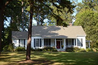
The Burnett House was a historic house in rural White County, Arkansas. It was located on the north side of County Road 766, about 0.75 miles (1.21 km) west of County Road 760, and about 3 miles (4.8 km) northwest of the center of Searcy. It was a two-story I-house with a side gable roof, weatherboard siding, a full-width two-story porch across its front, and a rear ell. The porch was supported by Craftsman-style posts set on stone piers, a likely 20th-century alteration. The house was built about 1870, and typified rural vernacular construction in the county from the period, and was one of the only known examples to survive with the ell.

The South Fork Bridge is a historic bridge spanning the South Fork Ouachita River in Fountain Lake, Arkansas. It formerly carried Arkansas Highway 128, whose modern bridge now stands just to the south, a short way east of its junction with Arkansas Highway 5. It is a two-span concrete closed-spandrel arch structure, with spans of 57 feet (17 m) and a roadway width of 16 feet (4.9 m). It was built in 1928 by a county crew, after major flooding in 1927 damaged road infrastructure in the area.


