
Gattman is a village in Monroe County, Mississippi. The population was 77 at the 2020 census, down from 90 in 2010.

Merwin is a village in Bates County, Missouri, and is part of the Kansas City metropolitan area within the United States. The population was 69 at the 2020 census.

Glen Allen is a village in central Bollinger County in Southeast Missouri, United States, located near the intersection of State Highway 34 and Route ZZ just west of Marble Hill. The population was 57 at the 2020 census.

Tina is a village in northeast Carroll County, Missouri, United States. The population was 139 at the 2020 census.

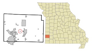
Jerico Springs is a village in Cedar County, Missouri, United States. The population was 160 at the 2020 census.

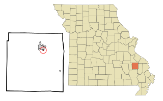
Umber View Heights is a village in Cedar County, Missouri, United States. The population was 41 at the 2020 census.

Luray is a village in Clark County, Missouri, United States. As of the 2020 census, its population was 73. It is part of the Fort Madison–Keokuk, IA-MO Micropolitan Statistical Area.

Big Lake is a village in Holt County, Missouri, United States. The population was 65 at the 2020 census.
Brooklyn Heights is a village in Jasper County, Missouri, United States. The population was 101 at the 2020 census. It is part of the Joplin, Missouri Metropolitan Statistical Area.
Cobalt is a village in Madison County, Missouri, United States. As of the 2020 census, the population was 264, up from 226 in 2010.

South Lineville is a village in Mercer County, Missouri, United States. The population was 13 at the 2020 census, a decline of fifteen people from the 2010 census.

Stoutsville is a village in Monroe County, Missouri, United States. The population was 37 at the 2020 census.

Annada is a village in Pike County, Missouri, United States. The population was 29 at the 2010 census.

Livonia is a village in eastern Putnam County, Missouri, United States. The population was 52 at the 2020 census.

Diehlstadt is a village in Scott County, Missouri, United States. The population was 161 at the 2010 census. Diehlstadt was founded by John Kirkpatrick.

Hillsdale is a village in St. Louis County, Missouri, United States. Greenwood Cemetery is located in Hillsdale. The population was 1,478 at the 2010 census.

Deerfield is a village in Vernon County, Missouri, United States. The population was 40 at the 2020 census.

Harwood is a village in northeast Vernon County, Missouri, United States. The population was 47 at the 2010 census. It was estimated to be 45 by the City of Harwood as of July 1, 2019.

Ong is a village in Clay County, Nebraska, United States. The population was 49 at the 2020 census. It is part of the Hastings, Nebraska Micropolitan Statistical Area.

Plainfield is a village in Waushara County, Wisconsin, United States. The village is located almost entirely within the Town of Plainfield. A tiny portion extends into adjacent Town of Oasis. The population was 897 at the 2010 census.

