Stoutsville, Missouri | |
---|---|
Coordinates: 39°32′52″N91°51′26″W / 39.54778°N 91.85722°W Coordinates: 39°32′52″N91°51′26″W / 39.54778°N 91.85722°W [1] | |
Country | United States |
State | Missouri |
County | Monroe |
Area | |
• Total | 0.83 sq mi (2.16 km2) |
• Land | 0.82 sq mi (2.13 km2) |
• Water | 0.01 sq mi (0.02 km2) |
Elevation | 610 ft (190 m) |
Population (2020) | |
• Total | 37 |
• Density | 44.96/sq mi (17.35/km2) |
Time zone | UTC-6 (Central (CST)) |
• Summer (DST) | UTC-5 (CDT) |
ZIP code | 65283 |
Area code | 573 |
FIPS code | 29-71026 [3] |
GNIS feature ID | 2399912 [1] |
Stoutsville is a village in Monroe County, Missouri, United States. The population was 37 at the 2020 census. [4]
Stoutsville was platted in 1871, and named after the family of Robert P. Stout, the original owners of the town site. [5] A post office called Stoutsville has been in operation since 1872. [6]
Stoutsville is located adjacent to the Buck Creek confluence with Mark Twain Lake and just south of U.S. Route 24. Paris is about ten miles to the southwest and Monroe City is about eleven miles to the northeast. [7]
According to the United States Census Bureau, the village has a total area of 0.82 square miles (2.12 km2), of which 0.81 square miles (2.10 km2) is land and 0.01 square miles (0.03 km2) is water. [8]
Census | Pop. | Note | %± |
---|---|---|---|
1880 | 118 | — | |
1890 | 253 | 114.4% | |
1900 | 196 | −22.5% | |
1910 | 315 | 60.7% | |
1920 | 247 | −21.6% | |
1930 | 153 | −38.1% | |
1940 | 179 | 17.0% | |
1950 | 146 | −18.4% | |
1960 | 109 | −25.3% | |
1970 | 61 | −44.0% | |
1980 | 34 | −44.3% | |
1990 | 26 | −23.5% | |
2000 | 44 | 69.2% | |
2010 | 36 | −18.2% | |
2020 | 37 | 2.8% | |
U.S. Decennial Census [9] |
As of the census [10] of 2010, there were 36 people, 16 households, and 14 families living in the village. The population density was 44.4 inhabitants per square mile (17.1/km2). There were 34 housing units at an average density of 42.0 per square mile (16.2/km2). The racial makeup of the village was 94.4% White and 5.6% from two or more races. Hispanic or Latino of any race were 2.8% of the population.
There were 16 households, of which 31.3% had children under the age of 18 living with them, 81.3% were married couples living together, 6.3% had a female householder with no husband present, and 12.5% were non-families. 12.5% of all households were made up of individuals. The average household size was 2.25 and the average family size was 2.43.
The median age in the village was 48.5 years. 16.7% of residents were under the age of 18; 5.7% were between the ages of 18 and 24; 16.7% were from 25 to 44; 41.6% were from 45 to 64; and 19.4% were 65 years of age or older. The gender makeup of the village was 50.0% male and 50.0% female.
As of the census [3] of 2000, there were 44 people, 24 households, and 15 families living in the village. The population density was 55.1 inhabitants per square mile (21.3/km2). There were 41 housing units at an average density of 51.4 per square mile (19.8/km2). The racial makeup of the village was 95.45% White and 4.55% Native American.
There were 24 households, out of which 4.2% had children under the age of 18 living with them, 62.5% were married couples living together, and 37.5% were non-families. 33.3% of all households were made up of individuals, and 8.3% had someone living alone who was 65 years of age or older. The average household size was 1.83 and the average family size was 2.20.
In the village, the population was spread out, with 6.8% under the age of 18, 2.3% from 18 to 24, 25.0% from 25 to 44, 31.8% from 45 to 64, and 34.1% who were 65 years of age or older. The median age was 52 years. For every 100 females, there were 100.0 males. For every 100 females age 18 and over, there were 115.8 males.
The median income for a household in the village was $31,875, and the median income for a family was $46,250. Males had a median income of $30,000 versus $13,750 for females. The per capita income for the village was $18,165. There were no families and 4.9% of the population living below the poverty line, including no under eighteens and none of those over 64.
Passaic is a town in Bates County, Missouri, and is part of the Kansas City metropolitan area within the United States.
West Line is a village in Cass County, Missouri. The population was 97 at the 2010 census. It is part of the Kansas City metropolitan area.
Leslie is a village in west central Franklin County, Missouri, United States. The population was 171 at the 2010 census.
Parkway is a village in Franklin County, Missouri, United States. The population was 439 at the 2010 census.
River Bend is a village in Jackson County, Missouri, United States. The population was 3 at the 2020 census. It is the only part of Jackson County that lies north of the Missouri River. In 1951, the Missouri River was relocated to a new channel, creating River Bend,. The county line still follows the original riverbed. It is part of the Kansas City metropolitan area. The mayor is Alex Dockler.
Evergreen is a village in Laclede County, Missouri, United States. The population was 28 at the 2010 census. It was named Twin Bridges at the 2000 census.
Cave is a populated place in Lincoln County, Missouri, United States. The population was 5 at the 2010 census. With a 2020 population of 5, it is the 939th largest city in Missouri and the 19481st largest city in the United States. Cave is currently declining at a rate of 0.00% annually and its population has decreased by 0.00% since the most recent census, which recorded a population of 5 in 2010.
Truxton is a village in Lincoln County, Missouri, United States. The population was 91 at the 2010 census.
Holliday is a village in Monroe County, Missouri, United States. The population was 114 at the 2020 census.
Leawood is a village in Newton County, Missouri, United States. The population was 682 at the 2010 census. It is part of the Joplin, Missouri Metropolitan Statistical Area.
Pascola is a village in Pemiscot County, Missouri, United States. The population was 108 at the 2010 census.
Flemington is a village in Polk County, Missouri, United States. The population was 148 at the 2010 census. It is part of the Springfield, Missouri Metropolitan Statistical Area.
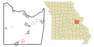
Hunnewell is a city in southeastern Shelby County, Missouri, United States. The population was 139 at the 2020 census.
Roscoe is a village in St. Clair County, Missouri, United States. The population was 89 at the 2020 census.
Velda Village Hills is a village in northeastern St. Louis County, Missouri, United States. The population was 1,055 at the 2010 census.
Moundville is a village in southwest Vernon County, Missouri, United States. The population was 124 at the 2010 census.
Champ is a village in St. Louis County, Missouri, United States. The population was 10 at the 2020 census.
Stoutsville is a village in Fairfield County, Ohio, United States. The population was 560 at the 2010 census.
Ionia is a village in northern Benton and southern Pettis counties in the U.S. state of Missouri. The population was 88 at the 2010 census.
Monroe City is a city in Marion, Monroe, and Ralls counties in the U.S. state of Missouri. The population was 2,652 at the 2020 census.