
Hillcrest Historic District is an historic neighborhood in Little Rock, Arkansas that was listed on the National Register of Historic Places on December 18, 1990. It is often referred to as Hillcrest by the people who live there, although the district's boundaries actually encompass several neighborhood additions that were once part of the incorporated town of Pulaski Heights. The town of Pulaski Heights was annexed to the city of Little Rock in 1916. The Hillcrest Residents Association uses the tagline "Heart of Little Rock" because the area is located almost directly in the center of the city and was the first street car suburb in Little Rock and among the first of neighborhoods in Arkansas.

The Apex Historic District is the historic commercial and residential center of Apex, North Carolina, a satellite town of the state capital Raleigh. The district revolves around Salem Street, the main thoroughfare in downtown Apex. In 2007, CNNMoney.com ranked Apex as the 14th best place to live in the United States. The report cited the Historic District as one reason for the award and described the district as "quaint, impressively intact, and with an array of commercial and residential buildings now serving visitors and residents alike." On March 17, 1994, the Apex Historic District was listed on the National Register of Historic Places. The district boundaries were expanded in 1995, 2002, and 2008, and include Hunter, Center, Chatham, Cunningham, Holleman, and Hughes Streets.

White River Junction Historic District is a historic district in the unincorporated village of White River Junction, within the town of Hartford, Vermont. It was first listed on the National Register of Historic Places in 1980, and its boundaries were increased in 2002 and 2019. It originally encompassed the central portion of the village's business district, and was then expanded to include a broader array of resources.
The Rogers Commercial Historic District, known informally as Historic Downtown Rogers, is a historic district in the central business district of Rogers, Arkansas. When it was first listed on the National Register of Historic Places in 1988, it was known as the Walnut Street Historic District; this was changed when the district was enlarged in 1993. The district encompasses a portion of the city's central business district, whose historical significance extends from about 1885 to the end of World War II.
The Hale Avenue Historic District encompasses a significant portion of the central business district of Osceola, Arkansas. It extends for five blocks along Hale Avenue, between Ash and Maple Streets, and includes a few buildings on adjacent streets. The focal point of the district is the Mississippi County Courthouse, and the block of buildings opposite it on Hale Avenue. Although Osceola was founded in 1875, it was relocated beginning in 1900 to be closer to the railroad, with Hale Avenue as the major east–west route. This began a period of growth in the city which continued through much of the 1920s. Most of buildings on these blocks of Hale Avenue result from this time, and a number of those built later were built in an architecturally sympathetic manner.

Holly Grove Cemetery is a historic cemetery, located on the south side of Crooked Bayou Drive, 3 miles (4.8 km) southeast of McGehee, Arkansas. The cemetery is the only surviving remnant of the community of Trippe Junction, established in 1857 by the families of William Fletcher Trippe and his brother-in-law Benjamin McGehee. A railroad spur line was constructed to the area in 1877, and a small town grew up around it. By the 1920s all of its businesses had failed, and by 1930 all but one building had succumbed to fire. The Holly Grove Methodist Church adjoined the cemetery, and was the site of many funeral services. The church was serving as a school when it burned in 1913. In 1958, a group of citizens raised money to assist with maintenance and upkeep of the cemetery. A bicentennial marker was erected by the Desha Historical Society in 1974. The southern section of the cemetery was listed on the National Register of Historic Places in 1999.

Holly Grove Presbyterian Church is a historic church at 244 East 2nd Street in Holly Grove, Arkansas. It is a single-story wood-frame building, with a gable-roofed rectangular sanctuary, a square tower off to one side, and a Sunday School addition to the rear. The exterior, originally clad in board-and-batten siding, is now finished in metal siding that closely resembles a c. 1900 residing. It exhibits a combination of Greek Revival and Gothic Revival features. It was built in 1881 for a congregation established in 1839, and was its second sanctuary, replacing one destroyed by fire in 1871.

U.S. Highway 71 is a U.S. highway that runs from Krotz Springs, LA to the Fort Frances–International Falls International Bridge at the Canadian border. In Arkansas, the highway runs from the Louisiana state line near Doddridge to the Missouri state line near Bella Vista. In Texarkana, the highway runs along State Line Avenue with US 59 and partially runs in Texas. Other areas served by the highway include Fort Smith and Northwest Arkansas.
The Piggott Commercial Historic District encompasses the original center of the city of Piggott, Arkansas, as originally platted out in 1887. It is centered on the square where the Clay County courthouse is located, buildings facing the courthouse square, and also buildings along some of the adjacent streets. In addition to the courthouse, the district includes the c. 1910 railroad depot, city hall, two churches, the 1930s Post Office building, a cotton gin, and a grain storage yard. The town grew because of the railroad, and the plentiful timber in the area, whose harvesting fueled the early economy in the region. The oldest building in the district is the 1897 Clay County Bank at 188 West Main Street.

The Walnut Ridge Commercial Historic District encompasses the historic town center of Walnut Ridge, Arkansas, the county seat of Lawrence County. The district includes a four-block stretch of Main Street on the northwest side of the railroad tracks, and extends for one and sometimes two blocks on either side. Walnut Ridge was founded as a railroad town in 1875, and soon became a leading economic center in the county. Most of its historic downtown consists of vernacular commercial architecture dating to the late 19th and early 20th centuries, built of masonry and brick, and one or two stories in height. Notable buildings include the 1924 Swan Theatre at 222 West Main Street, the 1935 Old Walnut Ridge Post Office at 225 West Main, and the 1965 Lawrence County Courthouse at 315 West Main, which replaced a c. 1900 structure.

The Hardy Downtown Historic District encompasses most of the central business district of the resort community of Hardy, Arkansas. It extends along Main Street, between Church and Cope Streets, and includes a few buildings on adjacent streets. Hardy was founded as a railroad town in the 1880s, but grew by the end of the 19th century into a resort community, serving as commercial center for vacationers from Memphis, Tennessee. Most of the 43 buildings in the district are between one and three stories in height, and of masonry construction. Twenty-four are historically significant, and many of the remaining buildings date to the early 20th century but have been altered in unsympathetic ways. Notable buildings include the Hardy Church of Christ, and the Raymond Daugherty House, one of the community's oldest buildings.

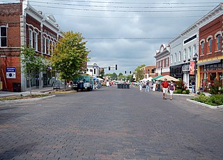
The Siloam Springs Downtown Historic District encompasses the historic downtown area of Siloam Springs, Arkansas. The district is roughly bounded by University Street, Broadway, and Sager Creek, with a few buildings on adjacent streets outside this triangular area. This business district was developed mainly between about 1896, when the railroad arrived, and 1940, and contains a significant number of buildings dating to that period. It also includes Siloam Springs City Park, the location of the springs that gave the city its name. Notable buildings include the First National Bank building, a c. 1890 Romanesque Revival building, and the c. 1881 Lakeside Hotel, which is one of the city's oldest commercial buildings.

Belle Grove Historic District is a predominantly residential historic district north of the central business district of Fort Smith, Arkansas. This area became an affluent residential area not long after Fort Smith was established in 1842, and was most heavily developed between about 1870 and 1930. It is one of the oldest residential neighborhoods in the state. It includes a cross-section of architectural styles popular in the late 19th and early 20th centuries, although its oldest building, the c. 1840 John Rogers House, is Greek Revival in style. The district is roughly bounded by North 4th, North 9th, North "B", and North "H" Streets.

The Mena Commercial Historic District encompasses the historic downtown area of Mena, Arkansas, the county seat of Polk County in western Arkansas. The district extends along Mena Street between Port Arthur and Gillham Avenues, extending a short way to the south on Sherwood Avenue, opposite the railroad tracks for which the town's existence is responsible. Mena was founded as a major railroad service town for the Kansas City, Pittsburg and Gulf Railroad, as its site was located midway between Port Arthur, Texas and Kansas City, Missouri. The railroad located a major service yard here, and the town grew up around it. Most of its commercial center was developed between 1896 and 1940, with a variety of one and two-story commercial brick buildings in typical early 20th-century styles. The district, listed on the National Register of Historic Places in 2009, includes four properties previously listed separately: the railroad station, Mena City Hall, the former Elks Lodge, and the former Studebaker Showroom.
The Lonoke Downtown Historic District encompasses a portion of the central business district of Lonoke, Arkansas. It extends south along Center Street, from the Lonoke County Courthouse to Front Street, and then one block east and west on both sides of Front Street. It extends eastward on the south side of Front Street another 1-1/2 blocks. Lonoke was founded as a railroad community in 1862, and this area represents the core of its downtown area for the period 1900–1945. Most of the district's 23 buildings are commercial structures, one to two stories in height, with brick facades.
The Morrilton Commercial Historic District encompasses the historic central business district of Morrilton, Arkansas. The L-shaped district includes two blocks of East Railroad and East Broadway, between Division and Chestnut Streets, and three blocks of Division and Chestnut Streets, between Broadway and Vine. This area was mostly developed between 1880 and the 1920s, and was heavily influenced by the railroad, which passes between Broadway and Railroad. Prominent buildings in the district include the Morrilton Post Office, Morrilton Railroad Station, First National Bank of Morrilton, and the Coca-Cola Building.

The Poultney Main Street Historic District encompasses the commercial and residential historic core of the village of Poultney, Vermont. Centered on Main Street and East Main Street, between College Avenue and St. Raphael's Catholic Church, the district includes a diversity of architectural styles, as well as civic, religious, and commercial functions spanning a period of more than 100 years. The district was listed on the National Register of Historic Places in 1988.

Highway 51 is a designation for two north–south state highways in Southwest Arkansas. One route of 53.37 miles (85.89 km) begins Highway 53 near Whelen Springs and runs north to US Highway 67 in Donaldson. A second route of 7.92 miles (12.75 km) runs parallel to US 270 northwest of Malvern. Both routes are maintained by the Arkansas Department of Transportation (ArDOT).

The Downtown Holly Commercial District is a commercial historic district located primarily South Saginaw Street and Battle Alley in Holly, Michigan. The district is roughly bounded by Maple Street, South Broad Street, First Street, and the Grand Trunk Railroad tracks. It was listed on the National Register of Historic Places in 1986.


