
The Yellowstone River is a tributary of the Missouri River, approximately 692 miles (1,114 km) long, in the Western United States. Considered the principal tributary of upper Missouri, via its own tributaries it drains an area with headwaters across the mountains and high plains of southern Montana and northern Wyoming, and stretching east from the Rocky Mountains in the vicinity of Yellowstone National Park. It flows northeast to its confluence with the Missouri River on the North Dakota side of the border, about 25 miles west of present-day Williston.

The Smith River flows from the Klamath Mountains to the Pacific Ocean in Del Norte County in extreme northwestern California, on the West Coast of the United States. The river, about 25.1 miles (40.4 km) long, all within Del Norte County, flows through the Rogue River – Siskiyou National Forest, Six Rivers National Forest, and Jedediah Smith Redwoods State Park.

Watson Mill Bridge State Park is a 1,018-acre (4.12 km2) Georgia state park located near Comer and Carlton on the South Fork of the Broad River. The park is named for the Watson Mill Bridge the longest original-site covered bridge in Georgia, which spans 229 feet (70 m) across the South Fork of the Broad River. The site is listed on the National Register of Historic Places as the Watson Mill Covered Bridge and Mill Historic District. The bridge, built in 1885, is supported by a Town lattice truss system held together with wooden pegs also known as trunnels. Georgia once had over 200 covered bridges, but only 20 now remain. The park also offers a scenic nature trail and a new hiking/riding trail that winds through the thick forests and along the rivers edge.

The Fort Madison Toll Bridge is a tolled, double-decked swinging truss bridge over the Mississippi River that connects Fort Madison, Iowa, and unincorporated Niota, Illinois. A double-track railway occupies the lower deck of the bridge, while two lanes of road traffic are carried on the upper deck. The bridge is about 1 mile (1.6 km) long with a swing span of 525 feet (160 m), and was the longest and largest double-deck swing-span bridge in the world when constructed in 1927. It replaced an inadequate combination roadway/single-track bridge completed in 1887. The main river crossing consists of four 270-foot (82 m) Baltimore through truss spans and a swing span made of two equal arms, 266 feet (81 m) long. In 1999, it was listed in the National Register of Historic Places under the title, Fort Madison Bridge, ID number 99001035. It was also documented as survey number IA-62 by the Historic American Engineering Record, archived at the Library of Congress. Construction and photographic details were recorded at the time in Scientific American magazine.

The Humpback Covered Bridge located in the U.S. state of Virginia, is one of the few remaining covered bridges in the United States that was built higher in the middle than on either end; hence the name of "humpback". The bridge was built in 1857 and is also the oldest remaining covered bridge in the state of Virginia. Its WGCB number is 46-03-01. The bridge spans a tributary of the Jackson River known as Dunlap Creek, for a distance of 109 feet (33 m). The humpback feature is 4 feet (1.2 m) higher in the center than at either end. The bridge is located near the city of Covington, Virginia.

The Wanette–Byars Bridge is a long bridge in central Oklahoma. It crosses the Canadian River between Byars in McClain County and Wanette in Pottawatomie County. The bridge is on a county road, not a state-designated highway.

The Grand Loop Road is a historic district which encompasses the primary road system in Yellowstone National Park. Much of the 140-mile (230 km) system was originally planned by Captain Hiram M. Chittenden of the US Army Corps of Engineers in the early days of the park, when it was under military administration. The Grand Loop Road provides access to the major features of the park, including the Upper, Midway and Lower geyser basins, Mammoth Hot Springs, Tower Fall, the Grand Canyon of the Yellowstone and Yellowstone Lake.

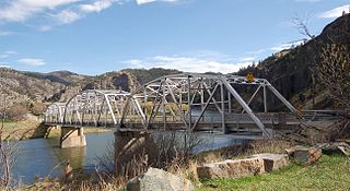
The Powder River Bridge is a bridge spanning the Powder River just above its confluence with the Yellowstone River in Prairie County, Montana. It was added to the National Register of Historic Places on January 4, 2010. It is a steel truss style bridge built in 1946. The bridge is 633 feet in length consisting of a 203-foot main truss span and two 163-foot truss spans.

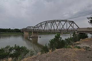
The Yellowstone River Bridge is a site on the National Register of Historic Places located in Fallon, Montana. It was added to the Register on January 4, 2010. The Yellowstone River Bridge near the community of Fallon is a 2-span riveted continuous steel Warren through truss. Built between 1943 and 1944, the bridge was one of only a very few major bridge projects undertaken by the Montana Highway Department during World War II.

The Cameron Suspension Bridge crosses the Little Colorado River at Cameron, Arizona, United States.

The AJX Bridge is a historic Pratt truss bridge in southwestern Johnson County, Wyoming. The bridge was built in 1931 across the South Fork of the Powder River near Kaycee, Wyoming. AJX Bridge was built to provide a river crossing for U.S. Route 87. It was placed on the National Register of Historic Places in 1985 as part of a Multiple Property Submission devoted to historic bridges in Wyoming.
Hardy Bridge is a Warren through truss, three-span, two-lane bridge in the western United States. It crosses the Missouri River and is located at milepost 6 on Old U.S. Route 91, about fourteen miles (23 km) southwest of Cascade, Montana, which is southwest of Great Falls.

Natural Pier Bridge is a steel Warren through truss bridge spanning the Clark Fork river located 1 mile (1.6 km) west of Alberton, Montana, United States, which incorporates a natural rock outcrop as anchorage for a pier. It was nominated to the National Register of Historic Places as part of a related group of historic Montana bridges known as Montana's Historic Steel Truss Bridges and achieved listing on January 4, 2010. Built in 1917 by the Lord Construction Company of Missoula, Montana, it is one of only a few remaining bridges of its type in the state, and of those it is the only one that incorporates a natural feature in its design.

The bridge is significant locally as the only Pratt through-truss bridge remaining in Kosciusko County, and is important regionally as one of the few surviving spans built by the Bellefontaine Bridge and Iron Company.

The Brookline-Newfane Bridge is a historic bridge spanning the West River between Brookline and Newfane, Vermont on Grassy Brook Road. It is a camelback through truss bridge, built in 1928 by the Berlin Construction Company in the wake of Vermont's devastating 1927 floods. The bridge was listed on the National Register of Historic Places in 2007 as Bridge 19, at which time it was one of seven surviving camelback bridges in the state. It last underwent a major rehabilitation in 2003-4.
The West Milton Bridge is a steel girder bridge carrying Bear Trap Road across the Lamoille River in Milton, Vermont, United States. It was built as a replacement for a 1902 Pennsylvania truss bridge, which was relocated to the site of the Swanton Covered Railroad Bridge, and is listed on the National Register of Historic Places.
Completed in 1926 at a cost of $305,000, the Bell Street Bridge crosses the Yellowstone River in Glendive, Montana. Designed by the Montana Highway Commission and built by contractor Boomer, McGuire & Blakesley, the 1,352 feet (412 m) long, 20 feet (6.1 m) wide bridge consists of six Warren through truss spans, each roughly 219 feet (67 m) long, and a concrete approach span about 38 feet (12 m) long. It was listed on the National Register of Historic Places in 1988. At one time the main highway bridge over the river, Montana DOT rehabilitated and converted it for pedestrian use in 1992 when the bridge on the I-94 Business Loop was built 300’ to the north.

The Scenic Bridge crossing Clark Fork River about 4 miles (6.4 km) east of Tarkio in Mineral County, Montana, was built in 1928. It is located at Milepost 0 on Old U.S. Route 10 West. The bridge has also been denoted 24MN304 and MDT No. L31012000+08. It was listed on the National Register of Historic Places in 2010.
The Forsyth Bridge across the Yellowstone River in Forsyth, Montana is a Pennsylvania truss bridge which was built in 1905. It has also been known as Yellowstone River Bridge. It was listed on the National Register of Historic Places in 1990.

The St. Anthony Pegram Truss Railroad Bridge, in Fremont County, Idaho near St. Anthony, Idaho, was built in 1896. It was listed on the National Register of Historic Places in 1997.


