Inishbiggle

Last updated

Inishbiggle
Native name:
Inis Bigil
View to Inisbiggle (geograph 3263430) (cropped).jpg
View to Inisbiggle from nearby Achill Island
Island of Ireland location map.svg
Red pog.svg
Inishbiggle
Geography
Location Atlantic Ocean
Coordinates 53°59′45″N9°54′15″W / 53.99583°N 9.90417°W / 53.99583; -9.90417
Administration
Province Connacht
County Mayo
Demographics
Population12 (2022) [1]

Inishbiggle (Irish : Inis Bigil) is a small inhabited island off the coast of Ballycroy in County Mayo. Its name in Irish means "Vigil Island"

Contents

Geography

The island is situated between the northeast of Achill Island and the mainland, and is accessed by boat from either Doran's point at Ballycroy or Bullsmouth, Dooniver on Achill Island. The island is 2½ km x 1½ km, or 650 acres (2.6 km2) in area.

Description

The main activities are sheep and cattle farming, fishing and winkle picking.[ citation needed ] Facilities on the island included a school and a post office, both now closed.

Plans to build a cable-car link across the Bullsmouth Channel, one of the strongest currents in Europe separating the island from Achill had been under discussion since 1996, but have now been abandoned. Planning permission for the cablecar was denied by Mayo County Council on the grounds that "It would be visually obtrusive in an area of special scenic importance, that it would create traffic problems and that it would devalue houses in the vicinity." [2]

Unpredictable currents in the channel during winter months can render the island inaccessible, even though the passage during fair weather is about ten minutes in the traditional boat, the currach.[ citation needed ] Emergency access is by helicopter.[ citation needed ]

Demographics

The table below reports data on Inishbiggle's population taken from Discover the Islands of Ireland (Alex Ritsema, Collins Press, 1999) and the Census of Ireland.

Historical population
YearPop.±%
184167    
185161−9.0%
18610−100.0%
1871154    
1881171+11.0%
1891135−21.1%
1901135+0.0%
1911149+10.4%
1926162+8.7%
YearPop.±%
1936157−3.1%
1946106−32.5%
1951123+16.0%
1956116−5.7%
1961113−2.6%
1966103−8.8%
1971112+8.7%
197997−13.4%
198189−8.2%
YearPop.±%
198669−22.5%
199151−26.1%
199648−5.9%
200239−18.8%
200624−38.5%
2011 25+4.2%
2016 18 [3] −28.0%
202212−33.3%
Source: Central Statistics Office. "CNA17: Population by Off Shore Island, Sex and Year". irishislands.info. Retrieved 12 October 2016.

See also

Related Research Articles

<span class="mw-page-title-main">Achill Island</span> Island off the western coast of Ireland, in County Mayo

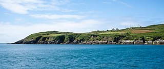
Achill Island is the largest of the Irish isles and lies off the west coast of Ireland in County Mayo. It has a population of 2,345. Its area is 148 km2 (57 sq mi). Achill is attached to the mainland by Michael Davitt Bridge, between the villages of Achill Sound and Polranny. A bridge was first completed here in 1887. Other centres of population include the villages of Keel, Dooagh, Dooega, Dooniver, and Dugort. The parish's main Gaelic football pitch and secondary school are on the mainland at Polranny. Early human settlements are believed to have been established on Achill around 3000 BC. The island is 87% peat bog. The parish of Achill consists of Achill Island, Achillbeg, Inishbiggle and the Corraun Peninsula.

<span class="mw-page-title-main">County Mayo</span> County in Ireland

County Mayo is a county in Ireland. In the West of Ireland, in the province of Connacht, it is named after the village of Mayo, now generally known as Mayo Abbey. Mayo County Council is the local authority. The population was 137,231 at the 2022 census. The boundaries of the county, which was formed in 1585, reflect the Mac William Íochtar lordship at that time.

<span class="mw-page-title-main">Cape Clear Island</span> Island off the southwest coast of Ireland

Clear Island or Cape Clear Island is an island off the south-west coast of County Cork in Ireland. It is the southernmost inhabited part of Ireland and has a population of 147 people. It is an official Gaeltacht area, and most inhabitants speak Irish and English. Its nearest neighbouring island is Sherkin Island, which is 2 kilometres east of the Cape Clear Island. The island is divided into east and west halves by an isthmus called the Waist, with the North Harbour to the landward side and the South Harbour on the seaward side. Ferries sail regularly from the North Harbour to Schull and Baltimore on the mainland. The South Harbour is a popular berth for yachts and pleasure boats.

<span class="mw-page-title-main">Westport, County Mayo</span> Town in County Mayo, Ireland

Westport is a town in County Mayo in Ireland. It is at the south-east corner of Clew Bay, an inlet of the Atlantic Ocean on the west coast of Ireland. Westport is a tourist destination and scores highly for quality of life. It won the Irish Tidy Towns Competition three times in 2001, 2006 and 2008. In 2012 it won the Best Place to Live in Ireland competition run by The Irish Times.

<span class="mw-page-title-main">Lambay Island</span> Private island off the Dublin coast, Ireland

Lambay Island, often simply Lambay, is an island in the Irish Sea off the coast of north County Dublin, Ireland. The largest island off the east coast of Ireland, it is four kilometres (2 mi) offshore from the headland at Portrane, and is the easternmost point of the province of Leinster. Of volcanic origin, it has been inhabited since the prehistoric period and has been the subject of multiple archaeological studies. Lambay has notable populations of seabirds, a range of local fauna, some not found elsewhere in Ireland, and a colony of wallabies, as well as more than 300 plant varieties, and was the subject of major studies of flora and bird, and a major multidisciplinary study of flora and fauna between 1905 and 1907. The island is privately owned by a trust for members of certain branches of the Baring family and managed by the current Baron Revelstoke. It has a very small permanent population and few buildings but hosts some day visitors and short-stay guests, and there is a working farm.

<span class="mw-page-title-main">Clare Island</span> Island in County Mayo, Ireland

Clare Island, also historically Inishcleer, is a mountainous island guarding the entrance to Clew Bay in County Mayo, Ireland. Historically part of the kingdom of Umhaill, it is famous as the home of the 16th century pirate queen Gráinne O'Malley. The population of the island is 138 according to the 2022 census. To the south-west lies Inishturk (inhabited) and Caher Island (uninhabited), and to the north is Achill Island.

Collanmore Island is an island in Clew Bay, County Mayo, Ireland.

<span class="mw-page-title-main">Bere Island</span> Island in County Cork, Ireland

Bere Island or Bear Island is an island in Bantry Bay off the Beara Peninsula in County Cork, Ireland. It spans roughly 10 km x 3 km, with an area of 17.68 km² and, as of the 2022 census, had a population of 218 people.
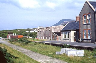
<span class="mw-page-title-main">Inishturk</span> Island in County Mayo, Ireland

Inishturk is an inhabited island of County Mayo, in Ireland.

<span class="mw-page-title-main">Achillbeg</span>

Acaill Bheag (Achillbeg) is a small island in County Mayo, Ireland, just off the southern tip of Achill Island.

<span class="mw-page-title-main">Inishbofin, County Donegal</span> Island in County Donegal, Ireland

Inishbofin, also Inishbofinne, is an island and townland off the coast of Machaire Uí Rabhartaigh (Magheraroarty), County Donegal, Ireland.

<span class="mw-page-title-main">Rutland Island, County Donegal</span> Island and surrounding area in Ireland

Rutland Island, also sometimes known as Inishmacadurn, is an island in County Donegal, Ireland, and an electoral and census reporting district covering it, surrounding islands and part of the mainland. The island itself has no permanent inhabitants, but the district, which includes Burtonport and its environs, had 1,428 residents in 2006. The island lies between Burtonport and the inhabited Arranmore Island, and is not officially served by ferry.

<span class="mw-page-title-main">Gola Island</span> Offshore island in County Donegal, Ireland

Gola is a small island off the coast of Gweedore, County Donegal, Ireland. It was unpopulated as late as 1996 but more recently people have started to return. A ferry service operates during the summer holiday season and on request for the remainder of the year.

<span class="mw-page-title-main">Pól Ó Foighil</span> Irish Fine_Gael politician (1928–2005)

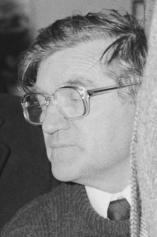
Pól Ó Foighil was an Irish politician and activist for Irish-speaking, coastal and island communities. A teacher turned co-operative manager, he was an active member of the Fine Gael party, and as a long-serving councillor he was the party's only elected representative in the Connemara Gaeltacht for two decades. He also served as a senator from 1989 to 1993.

<span class="mw-page-title-main">Doohoma</span> Townland in Connacht, Ireland

Doohoma or Doohooma is a townland, peninsula and a census town in the County Mayo Gaeltacht, Ireland. It is located on Ireland's Atlantic coastline overlooking Achill Island and the Mullet Peninsula.

Dún Ibhir, meaning "Ibhir's stronghold", or "Ibhir's fort" is a Gaeltacht village on Achill Island in County Mayo, Ireland.

<span class="mw-page-title-main">Corraun Peninsula</span> Peninsula on the west coast of Ireland

The Corraun Peninsula, also spelt Currane, is a peninsula in County Mayo, on the west coast of Ireland. It extends out from the mainland towards Achill Island.

<span class="mw-page-title-main">Long Island, County Cork</span>

Long Island, historically called Inishfada, is an island that lies south of Schull, County Cork, Ireland. It has a permanent population of no more than 10. The island is named for being 4.8 km (3.0 mi)long and only 0.8 km (0.5 mi) wide. It is the third largest of Carbery's Hundred Isles at 1.8 km2 (0.7 sq mi), after Sherkin Island and Clear Island. The island’s most distinctive landmark is Copper Point lighthouse at its eastern end, marking the entrance to Schull Harbour.

<span class="mw-page-title-main">Charles T. Meide</span> American underwater archaeologist

Charles T. Meide Jr., known as Chuck Meide, is an underwater and maritime archaeologist and currently the Director of LAMP, the research arm of the St. Augustine Lighthouse & Maritime Museum located in St. Augustine, Florida. Meide, of Syrian descent on his father's side, was born in Jacksonville, Florida, and raised in the nearby coastal town of Atlantic Beach. He earned BA and MA degrees in Anthropology with a focus in underwater archaeology in 1993 and 2001 from Florida State University, where he studied under George R. Fischer, and undertook Ph.D. studies in Historical Archaeology at the College of William and Mary starting the following year. Meide has participated in a wide array of shipwreck and maritime archaeological projects across the U.S., especially in Florida, and throughout the Caribbean and Bermuda and in Australia and Ireland. From 1995 to 1997 he participated in the search for, discovery, and total excavation of La Salle's shipwreck, La Belle , lost in 1686. From December 1997 to January 1998 he served as Co-Director of the Kingstown Harbour Shipwreck Project, an investigation sponsored by the Institute of Maritime History and Florida State University into the wreck of the French frigate Junon (1778) lost in 1780 in St. Vincent and the Grenadines. In 1999 he directed the Dog Island Shipwreck Survey, a comprehensive maritime survey of the waters around a barrier island off the coast of Franklin County, Florida, and between 2004 and 2006 he directed the Achill Island Maritime Archaeology Project off the coast of County Mayo, Ireland. Since taking over as Director of LAMP in 2006, he has directed the First Coast Maritime Archaeology Project, a state-funded research and educational program focusing on shipwrecks and other maritime archaeological resources in the offshore and inland waters of Northeast Florida. In 2009, during this project, Meide discovered the "Storm Wreck," a ship from the final fleet to evacuate British troops and Loyalist refugees from Charleston at the end of the Revolutionary War, which wrecked trying to enter St. Augustine in late December 1782. He led the archaeological excavation of this shipwreck site each summer from 2010 through 2015, overseeing the recovery of thousands of well-preserved artifacts.

References