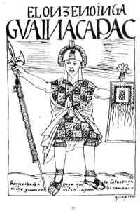
Huayna Capac, Guayna Cápac, Guayna Capac, Huain Capac, Guain Capac, Guayana Capac, Wayna Kapa, Wayn Capac, Wayana Qhapaq, Wayna Kapak, Wayna Capac, or Wayna Qhapaq (1464/1468–1524) was the third Sapan Inka of the Inca Empire, born in Tumipampa sixth of the Hanan dynasty, and eleventh of the Inca civilization. As other Sapa Inkas, Wayna Qhapaq subjects commonly approached him adding epithets and titles when addressing him, commonly as Wayna Qhapaq Inka Sapa'lla Tukuy Llaqt'a Uya "Unique Sovereign Wayna Qhapaq Listener of All Peoples", His original name was Titu Kusi Wallpa. He was the successor to Tupaq Inka Yupanki.

Inkallaqta is a monumental Inca site in central Bolivia. It is located in the Cochabamba Department, Carrasco Province, Pocona Municipality, approximately 130 kilometers east of Cochabamba. It was most recently excavated by Larry Coben.He believes that the site was used to perform rites for the ceremonial calendar. The site has several important structures such as the Kallanka. It was the largest single roofed room in the western hemisphere when it was built, and measures 78 by 25 meters. There's also an ushnu or a ritual platform on the site. The Torreon of Inkallaqta is also located on this site. Located at the western side of the site this six sided structure supposedly had calendrical or astronomical significance. There is a zigzag wall immediately north of the site which is meant to mark and protect it.

Piki Mach'ay is an archaeological site in the Ayacucho Valley of Peru. Radiocarbon dates from this cave give a human presence ranging from 22,200 to 14,700 years ago, but this evidence has been disputed and a more conservative date 12,000 years BCE seems possible.

Tambomachay is an archaeological site associated with the Inca Empire, located near Cusco, Peru. An alternate Spanish name is El Baño del Inca.
Isla Incahuasi, Inkawasi or Inka Wasi is a hilly and rocky outcrop of land and former island in Bolivia situated in the middle of Salar de Uyuni, the world's largest salt flat, at an elevation of 3,656 meters. It is located in the Potosí Department, Daniel Campos Province, Tahua Municipality, Yonza Canton. Isla Incahuasi is the Spanish name where isla means island, Inca stands for Inca, and huasi is derived from the Quechua word wasi meaning house.
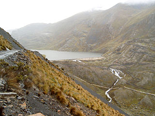
Inkachaka Dam is a dam in Bolivia situated in the La Paz Department, Pedro Domingo Murillo Province, La Paz Municipality, north east of La Paz.

Huamanmarca is an archaeological site in the region of Cusco, Peru. It is located in Huayopata District, La Convención Province, on the right bank of the Luq'umayu.

Incahuasi or Incawasi is an archaeological site in Peru. It is located in the Lima Region, Cañete Province, Lunahuaná District.

Inka Wasi or Inkawasi is an archaeological site in Peru. It is located in the Ayacucho Region, Parinacochas Province, Pullo District.

Inka Wasi is an archaeological site in the Huancavelica Region in Peru. The Inca palace is considered one of the most important monuments of the Huancavelica Region. Inka Wasi is located in the Huaytará Province, Huaytará District, about 25 km from Huaytará. It is situated at a height of 3,804 m (12,480 ft).
Tupu Inka is an archaeological site in Peru. It is located in the Puno Region, Yunguyo Province, Unicachi District.

Inka Mach'ay is an archaeological site in Bolivia. It is situated in the Chuquisaca Department, Oropeza Province, Chuquisaca Municipality, at a height of 3,510 metres (11,516 ft). Inka Mach'ay was declared a National Monument on May 27, 1958, by Supreme Decrete No. 4954.
Quillcay Machay or Qillqay Mach'ay is an archaeological site in Peru. It is situated in the Huánuco Region, Huamalíes Province, Singa District. The site is known for its rock paintings. It was declared a National Cultural Heritage of Peru by Resolución Directoral No. 533/INC on June 18, 2002.
Tampu Mach'ay or Tampumach'ay is an archaeological site in Peru. It is located in the Huancavelica Region, Tayacaja Province, Acostambo District. Tampu Mach'ay is situated near the main square of Acostambo at a height of about 3,400 metres (11,155 ft).
Inkapintay or Inkapintayuq is an archaeological site in Peru with a rock painting. It is situated in the Cusco Region, Urubamba Province, Ollantaytambo District, near Ollantaytambo. The figure which draws the attention possibly depicts a noble person.

Ahuila Gencha Machay is an archaeological site with cave paintings in Peru. It lies in the Huánuco Region, Huamalíes Province, Singa District. It is situated on the mountain Ocpay southwest of Singa, at a height of about 3,853 metres (12,641 ft).
Hatun Machay is a rock forest with archaeological remains in Peru. It was declared a National Cultural Heritage by Resolución Directoral No. 944/INC-2010 on May 7, 2010. Hatun Mach'ay is situated on the western side of the Cordillera Negra in the Ancash Region, Recuay Province, Pampas Chico District, at a height of about 4,200 metres (13,780 ft).
Cuchi Machay is an archaeological site with rock paintings in Peru. It is located in the Lima Region, Yauyos Province, Tanta District. Cuchi Machay was declared a National Cultural Heritage of Peru by Resolución Viceministerial No. 011-2013-VMPCIC-MC on February 7, 2013.
Piqui Machay is a mountain in the Andes of Peru, about 4,800 metres (15,748 ft) high. It is situated in the Cusco Region, Quispicanchi Province, Marcapata District. It lies southeast of the mountains Vizcachani, Allincapac and Huanacune. At the northern slopes of Piqui Machay there is a little lake named Jomercocha.
Killa Mach'ay is an archaeological site with rock paintings and petroglyphs in Peru. It is situated in the Huancavelica Region, Acobamba Province, Acobamba District. The site consists of caves with images of llamas, lines and people. It is situated at a height of 3,400 metres (11,155 ft).


