Chippewa National Forest is a National Forest located in north central Minnesota, United States, in the counties of Itasca, Cass and Beltrami. Forest headquarters are located in Cass Lake, Minnesota. There are local ranger district offices in Blackduck, Deer River and Walker.

Interstate Park comprises two adjacent state parks on the Minnesota–Wisconsin border, both named Interstate State Park. They straddle the Dalles of the St. Croix River, a deep basalt gorge with glacial potholes and other rock formations. The Wisconsin park is 1,330 acres (538 ha) and the Minnesota park is 298 acres (121 ha). The towns of Taylors Falls, Minnesota and St. Croix Falls, Wisconsin are adjacent to the park. Interstate Park is within the Saint Croix National Scenic Riverway and the Ice Age National Scientific Reserve. The western terminus of the Ice Age National Scenic Trail is on the Wisconsin side. On the Minnesota side, two areas contain National Park Service rustic style buildings and structures that are listed on the National Register of Historic Places.

St. Croix State Park is a state park in Pine County, Minnesota, USA. The park follows the shore of the St. Croix River for 21 miles (34 km) and contains the last 7 miles (11 km) of the Kettle River. At 33,895 acres (13,717 ha) it is the largest Minnesota state park. It was developed as a Recreational Demonstration Area in the 1930s, and is one of the finest surviving properties of this type in the nation. 164 structures built by the Civilian Conservation Corps and the Works Progress Administration survive, the largest collection of New Deal projects in Minnesota. As a historic district they were listed on the National Register of Historic Places and proclaimed a National Historic Landmark in 1997.

Scenic State Park is a Minnesota state park near Bigfork in Itasca County. It encompasses 3,936 acres (1,593 ha) of virgin pine forests that surround Coon and Sandwick Lakes. It also includes portions of Lake of the Isles, Tell Lake, Cedar Lake and Pine Lake. Established in 1921, the Ojibwe tribe had previously used the area for hunting. The park has places for camping, hiking, swimming, fishing, and canoeing.

Kooser State Park is a 250-acre (101 ha) Pennsylvania state park in Jefferson Township, Somerset County, Pennsylvania, in the United States. The park, which borders Forbes State Forest, was built in the 1930s by the Civilian Conservation Corps, who also built the 4-acre (1.6 ha) Kooser Lake by damming Kooser Run. Kooser State Park is on Pennsylvania Route 31 a one-hour drive from Pittsburgh. The park is surrounded by Forbes State Forest.

Pickett Civilian Conservation Corps Memorial State Park is a Tennessee state park in the upper Cumberland Mountains. It is located in Pickett County, northeast of the city of Jamestown, and is adjacent to the Big South Fork National River and Recreation Area. The park is located on 19,200 acres (78 km2) of wilderness including caves, natural bridges, and other rock formations. About 1,000 acres (4.0 km2) are managed by the Tennessee Department of Environment and Conservation as a state park, and the remainder of the property is managed by the Tennessee Division of Forestry as a state forest.

Bastrop State Park is a state park in Bastrop County in Central Texas. The park was established in 1938 and consists of stands of loblolly pines mixed with post oak and junipers.

Backbone State Park is Iowa's oldest state park, dedicated in 1919. Located in the valley of the Maquoketa River, it is approximately three miles (5 km) south of Strawberry Point in Delaware County. It is named for a narrow and steep ridge of bedrock carved by a loop of the Maquoketa River originally known as the Devil's Backbone. The initial 1,200 acres (490 ha) were donated by E.M. Carr of Lamont, Iowa. Backbone Lake Dam, a relatively low dam built by the Civilian Conservation Corps (CCC) in the 1930s, created Backbone Lake. The CCC constructed a majority of trails and buildings which make up the park.

Baker Ranger Station was established in 1911 at the edge of Baker, Nevada to administer U.S. government lands in White Pine County, Nevada. The original 80 acres (32 ha) plot was first known as the Baker Administrative Site, becoming a year-round ranger station in 1918 for the Baker Ranger District of Nevada National Forest. The compound became a guard station and work site with the division of Nevada National Forest into Humboldt and Toiyabe National Forests in 1957. In 1986 Great Basin National Park was established and the station was transferred to the National Park Service as an administrative center for the park.
Architects of the United States Forest Service are credited with the design of many buildings and other structures in National Forests. Some of these are listed on the National Register of Historic Places due to the significance of their architecture. A number of these architectural works are attributed to architectural groups within the Forest Service rather than to any individual architect. Architecture groups or sections were formed within engineering divisions of many of the regional offices of the Forest Service and developed regional styles.

Canelo Ranger Station, also known as Canelo Work Station, is a historic ranger station in the Coronado National Forest, within Santa Cruz County of southern Arizona. It is located in the ghost town of Canelo, within a small valley between the Canelo Hills on the west and the northern Huachuca Mountains on the east.

The Lowell Ranger Station compound is in the Coronado National Forest of southern Arizona. It is located in Pima County, near Tucson.

The Pinedale Ranger Station is in the Apache-Sitgreaves National Forests, and located near Pinedale in Navajo County, Arizona.

Upton State Forest is a publicly owned forest with recreational features primarily located in the town of Upton, Massachusetts, with smaller sections in the towns of Hopkinton and Westborough. The state forest encompasses nearly 2,800 acres (1,100 ha) of publicly accessible lands and includes the last remaining Civilian Conservation Corps (CCC) camp in Massachusetts, built in Rustic style. The CCC campground was listed on the National Register of Historic Places in 2014.

Townshend State Park is a state park in Townshend, Vermont. Embedded within Townshend State Forest, the park provides a camping facility and hiking trails for accessing Bald Mountain. The park's facilities were developed by the Civilian Conservation Corps in the 1930s, and are listed on the National Register of Historic Places for their well-preserved state.

Gifford Woods State Park is a state park located at the base of Pico Peak in Killington, Vermont. The wooded park provides camping, picnic, and fishing facilities, and has hiking trails, including a portion of the Appalachian Trail. It preserves an area of old-growth forest that has been designated a National Natural Landmark, and is accessible via an interpretive trail. The park was established in 1931. Part of it is listed on the National Register of Historic Places, for facilities developed by the Civilian Conservation Corps in the 1930s.

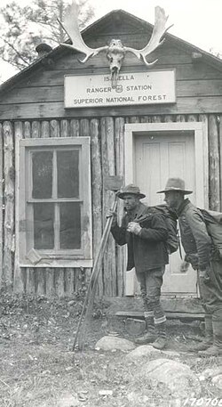
The Marcell Ranger Station is a historic United States Forest Service ranger station in Marcell Township, Minnesota. It was built from 1934 to 1935 to serve as the headquarters for the Marcell District of Chippewa National Forest. It was listed as a historic district on the National Register of Historic Places in 1994 for having state-level significance in the themes of architecture, conservation, and politics/government. It was nominated for its associations with the expansion and development of Chippewa National Forest during the New Deal, for being a well-preserved example of that era's Forest Service administrative facilities, and for its fine National Park Service rustic architecture. Marcell Ranger Station was closed in 2001 and the property was converted into a vacation rental known as Marcell Lodge. A 1963 office adjacent to Minnesota State Highway 38 was turned into the Edge of the Wilderness Discovery Center, a visitor center for the Edge of the Wilderness Scenic Byway.
Stillwater State Park is a state park located on Lake Groton in Groton, Vermont. The park is located in Groton State Forest close to the Groton Nature Center, Boulder Beach State Park and Big Deer State Park. The park offers camping, picnicking, and access to water-related activities on Lake Groton. The park was developed in the 1930s by crews of the Civilian Conservation Corps (CCC). It is open to the public between Memorial Day weekend and Columbus Day weekend; fees are charged for day use and camping.

New Discovery State Park is a state park near Marshfield, Vermont in the United States. It is one of seven state parks located in Groton State Forest. The park is on Vermont Route 232, offering camping, picnicking, and access to forest trails. The park was developed in the 1930s by the Civilian Conservation Corps; its major CCC-built facilities, located mainly in western Peacham, were listed on the National Register of Historic Places in 2002.

The Krassel Ranger Station, near Yellow Pine, Idaho, was built in 1937. It was listed on the National Register of Historic Places in 1992. The listing included four contributing buildings, a contributing structure, and a contributing site on 6.2 acres (2.5 ha).