Colonial National Historical Park is located in the Hampton Roads region of Virginia and is operated by the National Park Service of the United States government. The park protects and interprets several sites relating to the Colony of Virginia and the history of the United States more broadly, ranging from the site of the first landing of the English settlers who would settle at Jamestown, to the battlefields of Yorktown where the British Army was finally defeated in the American Revolutionary War. Over 3 million people visit the park each year.
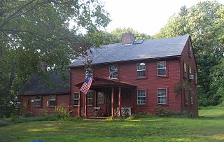
Oak Lawn or Oaklawn is a historical village in southwest Cranston, Rhode Island. Prior to being named "Oak Lawn" in 1872 the area was known as "Searle's Corner". The Edward Searle House, built in 1677, and one of the oldest standing structures in Rhode Island, is located in Oak Lawn. The village is known for its annual May Breakfast, a New England tradition that began in Oak Lawn in 1865 as a way for the members of the Oak Lawn Baptist Church to raise money for local American Civil War veterans. The 1855 Herman Melville novel "Israel Potter" is based on the life and adventures of an American Revolutionary soldier who was raised on a farm near present-day Oak Lawn. Oak Lawn is also the site of an important archeological excavation: in the 1950s archeologists discovered bowls and other Native American artifacts, carved from soapstone and dating back more than 10,000 years. In the pre-colonial era the area was populated with bands of the Narragansett Indians known as the "Meshanticut" and "Natick" Indians.

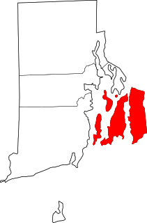
Saunderstown is a small village and historic district in the towns of Narragansett and North Kingstown in Washington County, Rhode Island, United States.
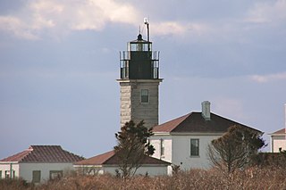
Beavertail Lighthouse was built in 1856 and is the premier lighthouse in Rhode Island, marking the entrance to Narragansett Bay. The 64-foot (20 m) lighthouse lies on the southernmost point of Conanicut Island in the town of Jamestown, Rhode Island in Beavertail State Park, on a site where beacons have stood since the early 18th century. The light provides navigation for boats and ships entering Narragansett Bay in the East Passage between Conanicut Island and Newport, Rhode Island on Aquidneck Island. Other lighthouses are visible from Beavertail Lighthouse, such as Castle Hill Lighthouse, Point Judith Light, and Rose Island Light.

The Artillery Park is an historic cemetery at North Road and Narragansett Avenue in Jamestown, Rhode Island. It is located at a high point on the southern part of Conanicut Island. It was originally laid out in 1656 as a burying ground and militia training ground, but appears to have been used as a burying ground only since the 1740s. When British forces occupied the island in 1776, there was a brief skirmish there, and the British afterward used the area as a military staging ground. The cemetery was listed on the National Register of Historic Places in 1973.

The Windmill Hill Historic District is a historic district encompassing a large rural landscape in Jamestown, Rhode Island. It is bounded on the north by Eldred Avenue, on the east by East Shore Road, on the south by Great Creek, and on the west by Narragansett Bay. The area's historical resources included six farmsteads, as well as the Quaker Meetinghouse, the Jamestown Windmill, and its associated miller's house and barn. The area is predominantly rolling hills with open pastureland and forest. The district was listed on the National Register of Historic Places in 1978. The area is also rich in prehistoric evidence of Native American occupation, which is the subject of the Jamestown Archeological District listing on the National Register.

The Conanicut Battery is a colonial and 20th century military battery in Jamestown, Rhode Island, west of Beaver Tail Road. The site offers a commanding view of the West Passage of Narragansett Bay.
The Jamestown Windmill is a smock mill in Jamestown, Rhode Island within the Windmill Hill Historic District on North Road north of Weeden Lane.
The Hazard Farmstead is a historic archaeological site in Jamestown, Rhode Island. It is the location of a major American Indian settlement whose artifacts have been dated from 2,500 BC to 1,000 AD. It appeared to be occupied seasonally from late summer to fall, and was intensively used during those times.
Old Friends Archeological Site is an archaeological historical site in Jamestown, Rhode Island.

The Furnace Hill Brook Historic and Archeological District in a historic district in Cranston, Rhode Island.
The Bouchard Archeological Site, RI-1025 is a prehistoric archaeological site in South Kingstown, Rhode Island, USA. The site, on a bluff overlooking Glen Rock Reservoir, has yielded evidence of Native American occupation from the Late Archaic to the Early Woodland periods. The site is governed by the Farmers Home Administration.

The Central Street Historic District of Narragansett, Rhode Island is a historic district on both sides of Central Street from Fifth Avenue to Boon Street in Narragansett. It encompasses a collection of well-preserved summer houses built for the most part between 1880 and the 1920s, as well as the traditional civic core of the town. The area is characterized by smaller wood-frame homes, generally either 1-1/2 or 2-1/2 stories in height, set on small lots. It includes three church buildings, all of which were built between 1870 and 1900, and the former Fifth Avenue School, which now serves as Narragansett's town hall.

The Crowfield Historic District is a small residential historic district in North Kingstown, Rhode Island. It encompasses a cluster of four early 20th-century summer houses, all connected via family or friendship connections to the writer Owen Wister. The occupy a large parcel of land sloping down to the shore of Narragansett Bay on the east side of Boston Neck Road, a short way north of the Jamestown Verrazzano Bridge. The area was named "Crowfield" by Elizabeth Middleton Cope, who built a Shingle-style mansion in 1906. Owen Wister, her uncle, built his house, Champ de Corbeau, in 1909-10 to a design by Grant Lafarge. The Jamieson House was also built in 1906, and was designed by the same architect, James P. Jamieson. The fourth house, Orchard House, was built in 1924. All are Shingle style houses. The compound is unusual for North Kingstown, where most summer estates were isolated individual properties.

Earlscourt Historic District is a residential historic district in Narragansett, Rhode Island, United States. It is centered on a stretch of Earles Court, between Gibson Avenue and Noble Street, and includes a few properties on the adjacent Gibson Avenue and Woodward and Westminster Streets. It includes nine residential properties developed in the 1880s and 1890s, during the height of Narragansett Pier's popularity as a summer resort community. All are in the then-popular Shingle Style, and most were designed by well-known architects. The Sherry Cottages, a series of four buildings on Gibson Avenue, were all designed by McKim, Mead & White, who also designed The Towers. The other development is that on Earles Court, designed by D. J. Jardine and Constable Brothers for Edward Earle, a New York lawyer. The central focus of this development is a stone tower which bisects the roadway.
The Great Salt Pond Archeological District is a historic district in New Shoreham, Rhode Island. The district was added to the National Register of Historic Places in 1990.
The Historic Village of the Narragansetts in Charlestown is an historic district in Charlestown, Rhode Island encompassing what were for nearly two centuries the reservation lands of the Narragansett people. The district covers 5,600 acres (23 km2) and is bounded by Route 112 on the east, U.S. Route 1 on the south, King's Factory Road on the west, and Route 91 on the north. These lands served as the Narragansett reservation between 1709 and 1880, when the tribe sold the land to the state and was formally detribalized. Because of this long period of Native occupation, the area is archaeologically important, containing both historic and prehistoric artifacts. The Narragansetts have since received federal recognition.
Parris Brook Historic and Archeological District is a historic district in Exeter, Rhode Island. The area includes remains of 18th- and 19th-century mill complexes, as well as prehistoric Native American rock shelters. It is mostly located in the Arcadia Management Area, a natural preserve managed by the state, and on adjacent private land.
The Potter Pond Archeological District is a large complex of archaeological sites in coastal South Kingstown, Rhode Island. The area is roughly bounded by United States Route 1, Point Judith Pond, Matunuck Beach Road, and the south coast, and includes 22 archaeologically significant sites dating from the Late Archaic through the Late Woodland periods.

Cedar Swamp Archeological District is a prehistoric and historic archaeologically sensitive area in eastern Westborough, Massachusetts, and extending into the northwest corner of Hopkinton. Cedar Swamp is an area of more than 2,600 acres (1,100 ha) of wetlands that include the headwaters area of the Sudbury River. Archeological surveys of the environmentally sensitive and critical area have identified many Native American sites of interest. It is believed that Native Americans prized wood from the cedar trees that grew in the area. The archeological district, which encompasses much of the Cedar Swamp area, was added to the National Register of Historic Places in 1988.