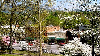
Tryon is a town in Polk County, on the southwestern border of North Carolina, United States. As of the 2020 census, the city population was 1,562. Located in the escarpment of the Blue Ridge Mountains, today the area is affluent and a center for outdoor pursuits, equestrian activity, and fine arts.

Greer is a city in the Greenville and Spartanburg counties in the U.S. state of South Carolina. As of the 2020 census, the population was 35,308, making it the 14th-most populous city in South Carolina. Greer is included in the Greenville-Anderson-Greer, SC Metropolitan Statistical Area, which is part of the Greenville-Spartanburg-Anderson, SC Combined Statistical Area in Upstate South Carolina.

A National Scenic Byway is a road recognized by the United States Department of Transportation for one or more of six "intrinsic qualities": archeological, cultural, historic, natural, recreational, and scenic. The program was established by Congress in 1991 to preserve and protect the nation's scenic but often less-traveled roads and promote tourism and economic development. The National Scenic Byways Program (NSBP) is administered by the Federal Highway Administration (FHWA).

U.S. Route 276 is a United States highway that runs for 106.4 miles (171.2 km) from Mauldin, South Carolina to Cove Creek, North Carolina. It is known both as a busy urban highway in Greenville, South Carolina and a scenic back-road in Western North Carolina. Despite its numbering, it does not intersect its parent route U.S. Route 76.
The Cherokee Path was the primary route of English and Scots traders from Charleston to Columbia, South Carolina in Colonial America. It was the way they reached Cherokee towns and territories along the upper Keowee River and its tributaries. In its lower section it was known as the Savannah River. They referred to these towns along the Keowee and Tugaloo rivers as the Lower Towns, in contrast to the Middle Towns in Western North Carolina and the Overhill Towns in present-day southeastern Tennessee west of the Appalachian Mountains.

Buffalo Bill Cody Scenic Byway is in the U.S. state of Wyoming and spans most of the distance from Cody, Wyoming to Yellowstone National Park. The 27.5-mile (44.3 km) scenic highway follows the north fork of the Shoshone River through the Wapiti Valley to Sylvan Pass and the eastern entrance to Yellowstone. Most of the scenic byway is contained within Shoshone National Forest and is also known as US Highway 14 (US 14), US 16 and US 20.

South Carolina Highway 11 (SC 11), also known as the Cherokee Foothills Scenic Highway, is a 119.850-mile (192.880 km) state highway through the far northern part of the U.S. state of South Carolina, following the southernmost peaks of the Blue Ridge Mountains. The route is surrounded by peach orchards, quaint villages, and parks. It is an alternative to Interstate 85 (I-85) and has been featured by such publications as National Geographic, Rand McNally, and Southern Living.

Delaware Route 52 (DE 52) is a state highway in New Castle County, Delaware. The route runs from U.S. Route 13 Business in downtown Wilmington north to Pennsylvania Route 52 (PA 52) at the Pennsylvania border near Centerville. DE 52 runs through the city of Wilmington and passes through areas of the Brandywine Valley north of Wilmington. DE 52 intersects Interstate 95 (I-95)/US 202 and DE 2 in Wilmington and DE 100/DE 141 and DE 82 in Greenville. The entire route is designated as part of the Brandywine Valley National Scenic Byway, a National Scenic Byway and Delaware Byway, while most of the route is also designated as part of the Harriet Tubman Underground Railroad Byway of the Delaware Byways system. The road was built as the Kennett Pike, a turnpike, between 1811 and 1813. The Kennett Pike was bought by Pierre S. du Pont in 1919 and was widened and paved before being sold to the State of Delaware for $1. The road received the DE 52 designation by 1936.

The Lariat Loop National Scenic and Historic Byway is a National Scenic Byway and a Colorado Scenic and Historic Byway located in Jefferson County, Colorado, USA. The byway is a 40-mile (64 km) loop in the Front Range foothills west of Denver through Golden, Lookout Mountain Park, Genesee Park, Evergreen, Morrison, Red Rocks Park, and Dinosaur Ridge. The Lariat Loop connects to the Mount Blue Sky Scenic Byway at Bergen Park.

Table Rock State Park is a 3,083-acre (12.48 km2) park at the edge of the Blue Ridge Mountains in northern Pickens County, South Carolina. The park includes Pinnacle Mountain, the tallest mountain totally within the state.

Price's Post Office or the Price House is a house built c. 1800 in Spartanburg County, South Carolina. Its name in the USGS Geographic Names Information System is Prices Post Office. It is located at the intersection of Oak View Farm Road, Old Switzer Road, and Price House Road. It was named to the National Register of Historic Places on October 28, 1969.

The Brick Tavern House is a former inn on the National Road west of St. Clairsville, Ohio, United States. One of the oldest National Road taverns still in existence, it was built in the early nineteenth century. Although it fell into dilapidation during the late twentieth century, it was named a historic site in 1995, and extensive restoration was to be performed in the early 2010s but to date, has not been.
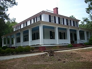
Ashtabula is a plantation house at 2725 Old Greenville Highway near Pendleton in Anderson County, South Carolina, USA. It has been also known as the Gibbes-Broyles-Latta-Pelzer House or some combination of one or more of these names. It was named in the National Register of Historic Places as a historic district on March 23, 1972. It is considered a significant example of a Lowcountry style plantation house built for a Charleston family in the Upstate in the early 19th century. It also is part of the Pendleton Historic District.

The George Salmon House, also known as the C. Douglas Wilson Farm, is located near Travelers Rest, South Carolina on SC Highway 414, off of US Highway 25.

The Hagood-Mauldin House is a property listed on the National Register of Historic Places located in Pickens, South Carolina. The house was originally constructed for James Earle Hagood ca.1856 in the town of Old Pickens but in 1868 when the Pickens District was divided into Oconee County and Pickens County, the house was disassembled, boards and beams numbered, and reassembled at its present location in the town of Pickens.

The Elk Lake Guard Station is a United States Forest Service cabin located in the Deschutes National Forest southwest of Bend, Oregon. The guard station was built in 1929 on the north shore of Elk Lake. It was used as a home base for Forest Service personnel who protected forest resources, maintained facilities, and aided summer visitors in the Cascade Lakes area of Central Oregon. After decades of use, the cabin was renovated in the late 1990s. Today, the historic guard station serves as a Forest Service visitor information center along the Cascade Lakes Scenic Byway. The Elk Lake Guard Station is listed on the National Register of Historic Places.
The East Tennessee Crossing Byway is a 83-mile (134 km) National Scenic Byway in the U.S. state of Tennessee. Established in 2009, it is one of the newest byways in the National Scenic Byway system. The scenic byway traverses mostly along an unsigned concurrency of U.S. Route 25E/State Route 32 (US 25E/SR 32) in East Tennessee.


