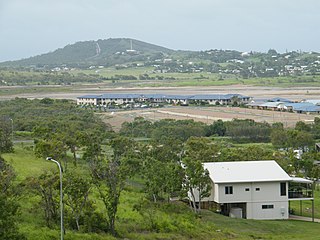
Yeppoon is a coastal town and locality in the Shire of Livingstone, Queensland, Australia. Yeppoon is renowned for its beaches, tropical climate, and the islands out on the bay. Located 41 kilometres (25 mi) from the city of Rockhampton, Yeppoon is the seat of the Shire of Livingstone and the principal town on the Capricorn Coast, a string of seaside communities stretching more than 150 kilometres (93 mi) from north to south. The beaches and shallow coves provide a destination both for tourists and retirees settling down in Central Queensland. Offshore, there are 27 islands including Great Keppel Island which is 20 kilometres (12 mi) from Yeppoon. In the 2021 census, the locality of Yeppoon had a population of 7,037 people; this does not include any neighbouring suburbs.

The Capricorn Coast is a stretch of coastline in Central Queensland, Australia and is part of the Shire of Livingstone.

Kinka Beach is a coastal rural locality in the Livingstone Shire, Queensland, Australia. In the 2021 census, Kinka Beach had a population of 674 people.

Keppel Sands is a coastal rural town and locality in the Livingstone Shire, Queensland, Australia. In the 2021 census, the locality of Keppel Sands had a population of 374 people.

Zilzie is a coastal locality in the Livingstone Shire, Queensland, Australia. In the 2021 census, Zilzie had a population of 2,846 people.

Cooee Bay is a coastal locality in the Livingstone Shire, Queensland, Australia. In the 2021 census, Cooee Bay had a population of 942 people.

Taranganba is a town and locality in the Livingstone Shire, Queensland, Australia. In the 2021 census, the locality of Taranganba had a population of 2,275 people.
Coowonga is a rural locality in the Shire of Livingstone, Central Queensland, Australia. In the 2021 census, the locality of Coowonga had a population of 255 people.

Lammermoor is a coastal locality on the Capricorn Coast in the Livingstone Shire, Queensland, Australia. In the 2021 census, Lammermoor had a population of 2,551 people.

Mount Chalmers is a rural town and locality in the Livingstone Shire, Queensland, Australia. In the 2021 census, the locality of Mount Chalmers had a population of 226 people.

Cawarral is a rural town and locality in the Livingstone Shire, Queensland, Australia. In the 2021 census, the locality of Cawarral had a population of 831 people.
Barmaryee is a rural locality in the Livingstone Shire, Queensland, Australia. In the 2021 census, Barmaryee had a population of 925 people.
Pacific Heights is a semi-rural locality in the Livingstone Shire, Queensland, Australia. In the 2021 census, Pacific Heights had a population of 1,111 people.
Ironpot is a rural locality in the Livingstone Shire, Queensland, Australia. In the 2021 census, Ironpot had a population of 184 people.
Nankin is a rural locality in the Livingstone Shire, Queensland, Australia. In the 2021 census, Nankin had a population of 176 people.

Tungamull is a rural locality in the Livingstone Shire, Queensland, Australia. In the 2021 census, Tungamull had a population of 429 people.

Thompson Point is a coastal locality in the Livingstone Shire, Queensland, Australia. It was the site of a short-lived town and port called Broadmount. In the 2021 census, Thompson Point had "no people or a very low population".

Hidden Valley is a mixed-use locality in the Livingstone Shire, Queensland, Australia. In the 2021 census, Hidden Valley had a population of 879 people.

Coorooman is a rural coastal locality in the Livingstone Shire, Queensland, Australia. In the 2021 census, Coorooman had a population of 97 people.
Greenlake is a rural locality in the Livingstone Shire, Queensland, Australia. In the 2021 census, Greenlake had "no people or a very low population".


