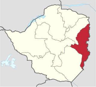
Manicaland is a province in eastern Zimbabwe. After Harare Province, it is the country's second-most populous province, with a population of 2.037 million, as of the 2022 census. After Harare and Bulawayo provinces, it is Zimbabwe's third-most densely populated province. Manicaland was one of five original provinces established in Southern Rhodesia in the early colonial period. The province endowed with country's major tourist attractions, the likes of Mutarazi Falls, Nyanga National Park and Zimbabwe's top three highest peaks. The province is divided into ten administrative subdivisions of seven rural districts and three towns/councils, including the provincial capital, Mutare. The name Manicaland is derived from one of the province's largest ethnic groups, the Manyika, who originate from the area north of the Manicaland province and as well as western Mozambique, who speak a distinct language called ChiManyika in Shona.

Mutare, originally known as Umtali, is the most populous city in the province of Manicaland, and the third most populous city in Zimbabwe, having surpassed Gweru in the 2012 census, with an urban population of 224,802 and approximately 260,567 in the surrounding districts giving the wider metropolitan area a total population of over 500,000 people. Mutare is also the capital of Manicaland province and the largest city in Eastern Zimbabwe.

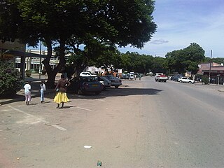
Nyanga, originally known as Inyanga, is a town in Zimbabwe.

The Eastern Highlands, also known as the Manica Highlands, is a mountain range on the border of Zimbabwe and Mozambique. The Eastern Highlands extend north and south for about 300 kilometres (190 mi) through Zimbabwe's Manicaland Province and Mozambique's Manica Province.
Rusape is a town in Zimbabwe.

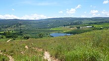
The Honde Valley extends from the eastern border of Zimbabwe into Mozambique. The valley is part of the Eastern Highlands. The valley is about 130 kilometres from Mutare, or 110 kilometres from Nyanga. The Nyanga Mountains and the Nyanga National Park forms the western boundary of the valley.

Chimanimani, originally known as Melsetter, is a mountainous district in Manicaland Province of eastern Zimbabwe. The district headquarters is the town of Chimanimani.

Nyanga National Park lies in the north of Zimbabwe's Eastern Highlands. One of the first national parks to be declared in the country, it contains the highest land in Zimbabwe, with green hills and perennial rivers. Most of its terrain consists of rolling downland, sometimes lightly wooded, lying at altitudes between 1,800–2,593 metres. Mount Nyangani, the highest point in Zimbabwe, lies in the centre of the park and Mutarazi Falls, Zimbabwe's highest waterfall, is in the south of the park. Nyanga National park incorporates the former Mutarazi Falls National Park on its southern boundary.

Gwanda is a town in Zimbabwe. It is the capital of the province of Matabeleland South, one of the ten administrative provinces in the country. It is also the district capital of Gwanda District, one of the seven administrative districts in the province.
Buhera District is a district in Manicaland Province, Zimbabwe.
Hauna is a village in the province of Manicaland, Zimbabwe located in the Honde Valley communal land about 55 km north of Mutare.It is the Growth Point Centre for Mutasa District in Manicaland. Hauna growth point is in Samanga B ward of Mutasa District and has a population of about 8,000. There is an aerodrome where small aeroplanes can land and take off. There is also a Police camp called Ruda Police Station which controls all police activities in Mutasa District.
Sanyati is a town in Zimbabwe.
Mount Darwin is a town in Mashonaland Central province in Zimbabwe.

Chimanimani, originally known as Melsetter, is a town in Zimbabwe.
Chipinge, originally known as Chipinga, is a town in Zimbabwe, located in Chipinge District, in Manicaland Province, in southeastern Zimbabwe, close to the border with Mozambique.
Mutasa District is one of seven districts in Manicaland Province of Zimbabwe. Mutasa District is located 30 km northeast Mutare and stretches up to the Honde Valley, which is about 100 km northeast of Mutare along a tarred road that branches off the Nyanga road.
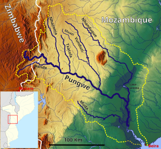
Honde River pronounced Horn-de is a river in Eastern Highlands of Zimbabwe which runs through the Honde Valley. It flows from Mount Inyangani on the western edges of Honde Valley where it is joined by several of its major tributaries: the rivers Mupenga, Buu, Mtarazi and Ngarura. It deposits its waters into the Pungwe River, already in Mozambique, which in turn empties in the Indian Ocean.
Murambinda is a town in Zimbabwe.

R5 Highway is a 270.8 kilometres (168.3 mi) regional road corridor running from Harare to Mutare. It is also known as the A3 Highway. It is part of the Beira–Lobito Highway.
Mutare District is a district in Manicaland Province of eastern Zimbabwe. The district headquarters is the city of Mutare. The district is basically subdivided into Bocha, City of Mutare and Jindwi. It boasts of a population of 531,562 as of 2022 Census making it the most populous in the province and country, with 224,802 of them in the city of Mutare and the rest in smaller urban settlements and rural areas of the district. Mutare district municipal administration is the hands of City Council of Mutare and Mutare Rural District Council both headquartered in the City of Mutare. The other well known areas of the district are Zimunya Township in Jindwi (Zimunya) which is basically part of Greater Mutare, Marange Clinic Shops in Bocha and St Noah College Area in Mafararikwa also in Bocha