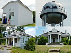
Junction City, Georgia | |
---|---|
Coordinates: 32°36′11″N84°27′29″W / 32.60306°N 84.45806°W | |
Country | United States |
State | Georgia |
County | Talbot |
Area | |
• Total | 2.48 sq mi (6.42 km2) |
• Land | 2.35 sq mi (6.09 km2) |
• Water | 0.13 sq mi (0.33 km2) |
Elevation | 689 ft (210 m) |
Population (2020) | |
• Total | 138 |
• Density | 58.70/sq mi (22.67/km2) |
Time zone | UTC-5 (Eastern (EST)) |
• Summer (DST) | UTC-4 (EDT) |
ZIP code | 31812 |
Area code | 706 |
FIPS code | 13-42800 [3] |
GNIS feature ID | 316309 [2] |
Junction City is a town in Talbot County, Georgia, United States. The population was 138 at the 2020 census.
Junction City was platted at the site of a railway junction, hence the name. [4] The Georgia General Assembly incorporated Junction City as a town in 1906. [5]
Junction City is located at 32°36′11″N84°27′29″W / 32.60306°N 84.45806°W (32.603083, -84.458190). [6]
The city is located along the Fall Line Freeway (GA state routes 96 and 540), which runs west to east through the town, leading east 15 mi (24 km) to Butler and west 39 mi (63 km) to Columbus. Georgia State Route 90 also runs through the town, leading northwest 8 mi (13 km) to Talbotton, the county seat, and southeast 8 mi (13 km) to Mauk.
According to the United States Census Bureau, the town has a total area of 2.5 square miles (6.5 km2), of which 2.5 square miles (6.5 km2) is land and 0.1 square miles (0.26 km2) (2.35%) is water.
Census | Pop. | Note | %± |
---|---|---|---|
1910 | 225 | — | |
1920 | 323 | 43.6% | |
1930 | 341 | 5.6% | |
1940 | 326 | −4.4% | |
1950 | 259 | −20.6% | |
1960 | 226 | −12.7% | |
1970 | 269 | 19.0% | |
1980 | 254 | −5.6% | |
1990 | 182 | −28.3% | |
2000 | 179 | −1.6% | |
2010 | 177 | −1.1% | |
2020 | 138 | −22.0% | |
U.S. Decennial Census [7] 1850-1870 [8] 1880 [9] 1890-1910 [10] 1920-1930 [11] 1930-1940 [12] 1940-1950 [13] 1960-1980 [14] 1980-2000 [15] |
Race / Ethnicity (NH = Non-Hispanic) | Pop 2000 [16] | Pop 2010 [17] | Pop 2020 [18] | % 2000 | % 2010 | % 2020 |
---|---|---|---|---|---|---|
White alone (NH) | 68 | 35 | 38 | 37.99% | 19.77% | 27.54% |
Black or African American alone (NH) | 108 | 135 | 98 | 60.34% | 76.27% | 71.01% |
Native American or Alaska Native alone (NH) | 2 | 0 | 0 | 1.12% | 0.00% | 0.00% |
Asian alone (NH) | 0 | 0 | 0 | 0.00% | 0.00% | 0.00% |
Pacific Islander alone (NH) | 0 | 0 | 0 | 0.00% | 0.00% | 0.00% |
Some Other Race alone (NH) | 0 | 0 | 0 | 0.00% | 0.00% | 0.00% |
Mixed Race or Multi-Racial (NH) | 0 | 1 | 2 | 0.00% | 0.56% | 1.45% |
Hispanic or Latino (any race) | 1 | 6 | 0 | 0.56% | 3.39% | 0.00% |
Total | 179 | 177 | 138 | 100.00% | 100.00% | 100.00% |
Junction City first appeared in the 1910 U.S. census, with a population of 225. [10] As of the 2020 census, its population was 138.
Talbot County is a county located in the west central portion of the U.S. state of Georgia. The 2020 census showed a population of 5,733. The county seat and largest city is Talbotton.
Seminole County is a county located in the southwestern corner of U.S. state of Georgia. As of the 2020 census, the population was 9,147. The county seat is Donalsonville.
Keysville is a town in Burke and Jefferson counties in the U.S. state of Georgia. As of the 2020 census, the city's population was 300.
Midville is a city in Burke County, Georgia, United States. The population was 269 at the 2010 census, and 385 in 2020. It is part of the Augusta, Georgia metropolitan area.
Edison is a city in Calhoun County, Georgia, United States. Per the 2020 census, the population was 1,230. The Edison Commercial Historic District is listed on the National Register of Historic Places.
Dooling is a town in Dooly County, Georgia, United States. The population was 68 at the 2020 census.
Union Point is a city in Greene County, Georgia, United States. As of the 2020 census, the city population was 1,597.
White Plains is a city in Greene County, Georgia, United States. The population was 284 at the 2010 census.
Oglethorpe is a city in Macon County, Georgia, United States. The population was 995 at the 2020 census, down from 1,328 in 2010. The city is the county seat of Macon County. It was named for Georgia's founder, James Oglethorpe.
Culloden is a city in Monroe County, Georgia, United States. The population was 200 in the 2020 census. It is part of the Macon metropolitan statistical area.
Coleman is a former incorporated city in Randolph County, Georgia, United States. It is listed as a census-designated place (CDP). The population was 149 at the 2000 census. The city was abolished by House Bill 1102 effective January 1, 2007, and no longer exists as a municipality.
Oliver is a city in Screven County, Georgia, United States. The population was 210 as of 2020.
Geneva is a town in Talbot County, Georgia, United States. The population was 75 at the 2020 census.
Woodland is a city in Talbot County, Georgia, United States. The population was 305 in 2020.
Danville is a town in Twiggs and Wilkinson counties in the U.S. state of Georgia. The population was 238 at the 2010 census, down from 373 in 2000.
Hannahs Mill is an unincorporated community and census-designated place (CDP) in Upson County, Georgia, United States. The population was 3,267 at the 2000 census.
Lincoln Park is an unincorporated community and census-designated place (CDP) in Upson County, Georgia, United States. The population was 1,122 at the 2000 census.
Salem is an unincorporated community and census-designated place (CDP) in Upson County, Georgia, United States. The population was 310 at the 2010 census.
Alamo is a town in Wheeler County, Georgia, United States. As of the 2020 census, the town had a population of 771. The town is the county seat of Wheeler County.
McIntyre is a town in Wilkinson County, Georgia, United States. The population was 575 in 2020.