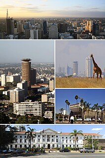
Nairobi is the capital and the largest city of Kenya. The name comes from the Maasai phrase Enkare Nairobi, which translates to "cool water", a reference to the Nairobi River which flows through the city. The city proper had a population of 4,397,073 in the 2019 census, while the metropolitan area has a population of 9,354,580. The city is popularly referred to as the Green City in the Sun.

Kenya, officially the Republic of Kenya, is a country in Eastern Africa. At 580,367 square kilometres (224,081 sq mi), Kenya is the world's 48th largest country by area. With a population of more than 47.6 million in the 2019 census, Kenya is the 29th most populous country. Kenya's capital and largest city is Nairobi, while its oldest city and first capital is the coastal city of Mombasa. Kisumu City is the third-largest city and also an inland port on Lake Victoria. Other important urban centres include Nakuru and Eldoret. As of 2020, Kenya is the third-largest economy in sub-Saharan Africa after Nigeria and South Africa. Kenya is bordered by South Sudan to the northwest, Ethiopia to the north, Somalia to the east, Uganda to the west, Tanzania to the south, and the Indian Ocean to the southeast. Its geography, climate and population vary widely, ranging from cold snow-capped mountaintops with vast surrounding forests, wildlife and fertile agricultural regions to temperate climates in western and rift valley counties and dry less fertile arid and semi-arid areas and absolute deserts.
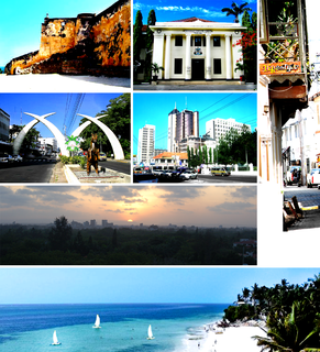
Mombasa is a coastal city in southeastern Kenya along the Indian Ocean. The city is known as the white and blue city in Kenya. It is the country's oldest and second-largest city, with a population of about 1,208,333 people according to the 2019 census. Its metropolitan region is the second-largest in the country, and has a population of 3,528,940 people.

Eldoret is a principal town in the Rift Valley region of Kenya and serves as the capital of Uasin Gishu County. The town is colloquially known as 'Sisibo'. As per the 2019 Kenya Population and Housing Census, Eldoret is the fifth most populated urban area in the country after Nairobi, Mombasa, Nakuru and Ruiru. Lying south of the Cherangani Hills, the local elevation varies from about 2100 meters at the airport to more than 2700 meters in nearby areas (7000–9000 feet). The population was 289,380 in the 2009 Census, and it is currently the fastest growing town in Kenya with 475,716 people according to 2019 National Census.
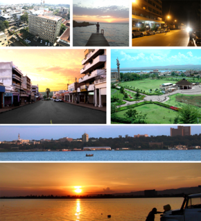
Kisumu is the third-largest city in Kenya after the capital, Nairobi, and the coastal city of Mombasa. It is the third-largest city in the Lake Victoria Basin. Kisumu is not far from Kogelo, a village known for being the hometown of Barack Obama Sr., the father to the 44th president of the United States. Culturally, Kisumu serves as the headquarters of the Luo speaking people of East Africa. It was the most prominent urban centre in the pre-colonial, post-colonial, and modern era for natives of Kavirondo region. Some of the most significant political events that have shaped the trajectory Kenya have happened in Kisumu including the famous political spat between founding president of Kenya Jomo Kenyatta and founding vice president Jaramogi Odinga during the opening of Jaramogi Oginga Odinga Teaching and Referral Hospital in 1969. Apart from being an important political city, it is one of the premier industrial and commercial centres in Kenya. The city is currently undergoing an urban rejuvenation of the downtown and lower town which includes modernizing the lake front, decongesting main streets, and making the streets pedestrian-friendly.

Meru is a city in eastern Kenya. It is the headquarters of the Meru County, and the seventh largest urban centre in the country. Meru forms a municipal council with a population of 240,900 residents.

Nyeri is a town situated in the Central Highlands of Kenya. It is the county headquarters of Nyeri County. The town was the central administrative headquarters of the country's former Central Province. Following the dissolution of the former provinces by Kenya's new constitution on 26 August 2010, the city is situated about 150 km north of Kenya's capital Nairobi, in the country's densely populated and fertile Central Highlands, lying between the eastern base of the Aberdare (Nyandarua) Range, which forms part of the eastern end of the Great Rift Valley, and the western slopes of Mount Kenya.
Malindi is a town on Malindi Bay at the mouth of the Sabaki River, lying on the Indian Ocean coast of Kenya. It is 120 kilometres northeast of Mombasa. The population of Malindi was 119,859 as of the 2019 census. It is the largest urban centre in Kilifi County.

Lamu or Lamu Town is a small town on Lamu Island, which in turn is a part of the Lamu Archipelago in Kenya. Situated 341 kilometres (212 mi) by road northeast of Mombasa that ends at Mokowe Jetty, from where the sea channel has to be crossed to reach Lamu Island. It is the headquarters of Lamu County and a UNESCO World Heritage Site.

Nakuru is a city in the Rift Valley region of Kenya. It currently serves as the capital of Nakuru County, and formerly as the capital of Rift Valley Province. As of 2019, Nakuru has an urban and rural population of 570,674 inhabitants, making it the largest urban center in the Rift Valley, with Eldoret in Uasin Gishu County following closely behind. It lies about 1,850 m above sea level.

Nyahururu is a town in Kenya, lying north east of Nakuru. The town derives its name from the Maasai word e-naiwurruwurr, meaning waterfall and/or windy or place of storms. It is located in Laikipia County. Despite this, Nyahururu formerly functioned as the administrative capital of Nyandarua County, before it became a county, until the headquarters was shifted to Ol Kalou. There have been calls for a reversal. The town has an urban population of 36,450. The town still continues to be a central economic power of the immediate former district of Nyandarua. For that reason, the town has strong economic ties to the two counties.
Kisii is a municipality and a major urban centre in south-western Kenya. It is the capital of the Kisii County which has a population of 1,266,860 according to the Kenya National Census of 2019. Kisii Town also serves as the main urban and commercial centre in the Gusii Highlands and the South Nyanza region and the second largest town in formerly greater Nyanza after Kisumu City. It is a bustling town and a home to several businesses, organizations, educational institutions and government agencies. Kisii municipality sits right at the centre of the western Kenya tourist circuit that includes the Tabaka Soapstone Carvings, Maasai Mara Game Reserve, Lambwe Valley Game Reserve and the entire Lake Victoria basin. The town continues to serve these former districts, the larger South Nyanza County and the Trans Mara area of western Narok County in commerce. Kisii town connects the Great Rift Valley and Nairobi to Migori and the Kenya-Tanzania border and has a sizable manufacturing industry based on agriculture primarily plantation farming.

Nanyuki is a Market town in Laikipia County of Kenya lying northwest of Mount Kenya along the A2 road and at the terminus of the branch railway from Nairobi. The name is derived from Enyaanyukie Maasai word for resemblance.

Machakos, also called Masaku is a town in Kenya, 63 km (39 mi) southeast of Nairobi. It is the capital of the Machakos County, Kenya. Its population is rapidly growing and was 150,041 as of 2009 and had a population of 1,421,932 as of 2019. People who live here are mostly of the Akamba ethnicity. Machakos is surrounded by hilly terrain, with a high number of family farms.
Busia is a town in Kenya. It is the capital and largest town of Busia County.
Thika is an industrial town and a major commerce hub in Kiambu County, Kenya, lying on the A2 road 42 kilometres (26 mi), Northeast of Nairobi, near the confluence of the Thika and Chania Rivers. Although Thika town is administratively in Kiambu County, the greater Thika area comprising such residential areas such as Bendor estate, Maporomoko, Thika Greens, Thika Golden Pearl, Bahati Ridge, Thika Sports Club, among others, are within Murang'a County. Thika has a population of 279,429 which is growing rapidly, as is the entire greater Nairobi area. Its elevation is approximately 1,631 metres (5,351 ft).
Kiambu is a town in Kiambu County, Kenya within the Nairobi Metropolitan Region. It is 14 km (8.7 mi) from the capital Nairobi. It has an population of 147,870. It is the capital of the Kiambu County, which bounds the northern border of Nairobi. Other proximate towns are Ruiru, Gatundu (NE), Limuru (NW) and Kabete (SW).

The Sultanate of Zanzibar, also known as the Zanzibar Sultanate, was a state controlled by the Sultan of Zanzibar, in place between 1856 and 1964. The Sultanate's territories varied over time, and at their greatest extent spanned all of present-day Kenya and the Zanzibar Archipelago of the Swahili Coast. After a decline, the state had sovereignty over only the archipelago and a 16-kilometre-wide (10 mi) strip along the Kenyan coast, with the interior of Kenya constituting the British Kenya Colony and the coastal strip administered as part of that colony de facto.

Operation Linda Nchi was an operation where the Kenya Defence Forces entered southern Somalia beginning in 2011. The Kenyan government declared the operation completed in March 2012, but its forces then joined AMISOM in Somalia.
