Kadakkad Kadakkadu | |
|---|---|
Municipal Division | |
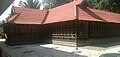
 Kadakkad Sree Bhadrakali Temple | |
 Kadakkad Location in Kerala, India  Kadakkad Kadakkad (India) | |
| Coordinates: 9°13′N76°42′E / 9.22°N 76.70°E | |
| Country | |
| State | Kerala |
| District | Pathanamthitta |
| Government | |
| • Body | Pandalam Municipality |
| Languages | |
| • Official | Malayalam |
| Time zone | UTC+5:30 (IST) |
| Telephone code | 04734 |
| Vehicle registration | KL-26 |
| Nearest city | Pandalam |
| Lok Sabha constituency | Pathanamthitta |
| Climate | Tropical monsoon (Köppen) |
Kadakkad is a municipal division in Pandalam. Situated in the banks of Achankovil river; Kadakkad divided into two divisions, Kadakkad North and Kadakkad South. [1] Pandalam-Pathanamthitta road is the major road passing and Kadakkad-Kaipattoor road proposed to be upgraded to NH standards. [2]