King City, Missouri

Last updated

King City, Missouri
Big-pump-king.jpg
Big Pump and wind farm in the Tri-County Historical Park
Gentry County Missouri Incorporated and Unincorporated areas King City Highlighted.svg
Location of King City, Missouri
King-city-mo-map.gif
U.S. Census Map
Coordinates: 40°03′02″N94°31′31″W / 40.05056°N 94.52528°W / 40.05056; -94.52528
Country United States
State Missouri
County Gentry
Area
[1]
  Total1.38 sq mi (3.58 km2)
  Land1.38 sq mi (3.58 km2)
  Water0.00 sq mi (0.00 km2)
Elevation
[2]
1,109 ft (338 m)
Population
 (2020)
  Total799
  Density578.15/sq mi (223.25/km2)
Time zone UTC-6 (Central (CST))
  Summer (DST) UTC-5 (CDT)
ZIP code
64463
Area code 660
FIPS code 29-38774 [3]
GNIS feature ID2395536 [2]

King City is a city in southwest Gentry County, Missouri, United States. The population was 799 at the 2020 census. [4]

Contents

History

John Pittsenbarger was the first European settler when he set up a tent in town in 1856. His application to name the town Petersburg was rejected because there was already a town of that name in Boone County, Missouri. According to local legend, the United States Postmaster General submitted his name. The Postmaster General at the time was Horatio King, (although the local history refers to Rufus King) [5]

The town became a stop on the St. Joseph and Des Moines Railway in 1878. The railway eventually became part of the Burlington Northern network and is currently abandoned.

In the first half of the 20th century, King City was the heart of a Kentucky bluegrass seed harvesting region stretching from Kearney, Missouri through King City to Maitland, Missouri, which claimed to harvest more bluegrass seeds than the entire state of Kentucky with King City resident John Weller claiming to be the "King of Blue Grass Raisers.". [6] Bluegrass seed production moved to the farming areas of the Pacific Northwest in the 1950s.

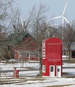
In the 1990s, the Big Pump, a 25-foot (7.6 m) high building resembling an electric gasoline pump, was moved from Maryville, Missouri to King City. It is on the National Register of Historic Places. Rufus Limpp, an oil jobber who built the station, is from King City (the Limpp Community Lake by King City is also named for him). [7] The Big Pump is located on the Tri-County Museum grounds. [8]

King City has only one grocery store, McCrea's, a family operated business started by Dean and Virginia McCrea. They have owned the store for more than 50 years, and Mr. McCrea still works there every day.

One prominent former King Citian was celebrated children's author Clyde Robert Bulla, who died in 2007 while living in Warrensburg, Missouri.

In 2006, St. Louis, Missouri-based Wind Capital Group began operation of 27 windmills a mile north of King City. The Bluegrass Ridge Wind Farm is the first commercial electric windmill operation in the state. Its windmills are 300 feet (91 m) high. [9] [10] The wind farm name celebrates the region's bluegrass heritage.

The Opera Hall Block was listed on the National Register of Historic Places in 2002. [11]

Education

There are two schools, an elementary and junior high/high school, both named King City R-1. The schools consisted of neighboring buildings for many years, until a fire confined both schools into a single building while a new high school was constructed. In a subsequent remodeling, the two separate buildings were joined with a classroom/hallway addition. They have finished construction; making a new Ag building and more classrooms in both the High School and Elementary.

Sports

University of Missouri standout and NFL Hall of Famer Roger Wehrli of the former St. Louis (now Arizona) Cardinals is an alumnus of King City High School. King City's football field is named Wehrli Field after him. Currently, committees are engaging in raising funds for the purpose of upgrading the track.

Geography

King City is located on US Route 169 three-quarters of a mile north of the Gentry-Dekalb county line. Stanberry is eleven miles to the north and Union Star in northwest Dekalb County is approximately six miles to the southwest. [12]

According to the United States Census Bureau, the city has a total area of 1.38 square miles (3.57 km2), all land. [13]

Demographics

Historical population
CensusPop.Note
1880 196
1890 622217.3%
1900 90545.5%
1910 9666.7%
1920 1,15019.0%
1930 1,101−4.3%
1940 1,1030.2%
1950 1,031−6.5%
1960 1,009−2.1%
1970 1,0231.4%
1980 1,0633.9%
1990 986−7.2%
2000 1,0122.6%
2010 1,0130.1%
2020 799−21.1%
U.S. Decennial Census [14]

2010 census

As of the census [15] of 2010, there were 1,013 people, 411 households, and 266 families residing in the city. The population density was 734.1 inhabitants per square mile (283.4/km2). There were 465 housing units at an average density of 337.0 per square mile (130.1/km2). The racial makeup of the city was 98.4% White, 0.1% African American, 0.1% Native American, 0.3% Asian, 0.2% from other races, and 0.9% from two or more races. Hispanic or Latino of any race were 1.1% of the population.

There were 411 households, of which 31.9% had children under the age of 18 living with them, 49.1% were married couples living together, 12.4% had a female householder with no husband present, 3.2% had a male householder with no wife present, and 35.3% were non-families. 30.7% of all households were made up of individuals, and 16.5% had someone living alone who was 65 years of age or older. The average household size was 2.38 and the average family size was 2.97.

The median age in the city was 40 years. 25.9% of residents were under the age of 18; 7.6% were between the ages of 18 and 24; 23.9% were from 25 to 44; 21.5% were from 45 to 64; and 20.9% were 65 years of age or older. The gender makeup of the city was 46.4% male and 53.6% female.

2000 census

As of the census [3] of 2000, there were 1,012 people, 418 households, and 285 families reside in the city. The population density was 732.8 inhabitants per square mile (282.9/km2). There were 485 housing units at an average density of 351.2 per square mile (135.6/km2). The racial makeup of the city was 98.72% White, 0.20% African American, 0.20% Native American, and 0.89% from two or more races. Hispanic or Latino of any race were 1.09% of the population.

There were 418 households, of which 33.5% had children under the age of 18 living with them. 56.9% of households were married couples living together, 7.7% had a female householder with no husband present, and 31.8% were non-families. 30.4% of all households were made up of individuals, and 17.2% had someone living alone who was 65 years of age or older. The average household size was 2.41 and the average family size was 2.98.

In the city, the population was spread out, with 28.0% under the age of 18, 7.4% from 18 to 24, 25.5% from 25 to 44, 18.7% from 45 to 64, and 20.5% who were 65 years of age or older. The median age was 37 years. For every 100 females, there were 92.8 males. For every 100 females age 18 and over, there were 83.2 males.

The median income for a household in the city was $24,605, and the median income for a family was $32,614. Males had a median income of $28,068 versus $18,750 for females. The per capita income for the city was $14,177. About 11.3% of families and 16.0% of the population were below the poverty line, including 20.2% of those under age 18 and 13.0% of those age 65 or over.

Related Research Articles

<span class="mw-page-title-main">Andale, Kansas</span> City in Sedgwick County, Kansas

Andale is a city in Sedgwick County, Kansas, United States. As of the 2020 census, the population of the city was 941.

<span class="mw-page-title-main">Rock Port, Missouri</span> City in Missouri, United States

Rock Port is a city in, and the county seat of, Atchison County, Missouri, United States. The population was 1,278 at the 2020 census.

<span class="mw-page-title-main">Mokane, Missouri</span> City in Missouri, United States

Mokane is a small city in southern Callaway County, Missouri, United States. The population was 185 at the 2010 census. It is part of the Jefferson City Metropolitan Statistical Area.

<span class="mw-page-title-main">Maitland, Missouri</span> City in Missouri, United States

Maitland is a city in Holt County, Missouri, United States. The population was 276 at the 2020 census. At one point the city billed itself as the "Bluegrass Mecca"—home to the largest bluegrass farm in the world.

<span class="mw-page-title-main">Linneus, Missouri</span> City in Missouri, United States

Linneus is a small city in Linn County, Missouri, United States. The population was 281 at the 2020 census. It is the county seat of Linn County.

<span class="mw-page-title-main">Green Ridge, Missouri</span> City in Missouri, United States

Green Ridge is a city located along Route 127 in Pettis County, Missouri, United States. The population was 476 at the 2010 census.

<span class="mw-page-title-main">Nelson, Missouri</span> City in Missouri, United States

Nelson is a city in Saline County, Missouri, United States. The population was 152 at the 2020 census.

<span class="mw-page-title-main">Lancaster, Missouri</span> City in Missouri, United States

Lancaster is a city in Schuyler County, Missouri, United States. As of the 2020 census, its population was 675. It is the county seat of Schuyler County.

<span class="mw-page-title-main">Bellerive Acres, Missouri</span> City in Missouri, United States

Bellerive Acres is a northern suburban city in St. Louis County, Missouri, United States. The population was 188 at the 2010 census. In April, 2015, the residents voted to change the village of Bellerive to a fourth class city named Bellerive Acres.

<span class="mw-page-title-main">Country Club Hills, Missouri</span> City in Missouri, United States

Country Club Hills is a city in St. Louis County, Missouri, United States. The population was 1,274 at the 2010 census.

<span class="mw-page-title-main">Crystal Lake Park, Missouri</span> City in Missouri, United States

Crystal Lake Park is a Missouri Class 4 city in St. Louis County, Missouri, United States. The population was 508 at the 2020 census.

<span class="mw-page-title-main">Flordell Hills, Missouri</span> City in Missouri, United States

Flordell Hills is a city in St. Louis County, Missouri, United States. The population was 822 at the 2010 census.

<span class="mw-page-title-main">Greendale, Missouri</span> City in Missouri, United States

Greendale is a city in St. Louis County, Missouri, United States. The population was 651 at the 2010 census.

<span class="mw-page-title-main">Lakeshire, Missouri</span> City in Missouri, United States

Lakeshire is a city in St. Louis County, Missouri, United States. The population was 1,432 at the 2010 census.

<span class="mw-page-title-main">Axtell, Nebraska</span> Village in Nebraska, United States

Axtell is a village in western Kearney County, Nebraska, United States. It is part of the Kearney, Nebraska Micropolitan Statistical Area. The population was 732 at the 2020 census.

<span class="mw-page-title-main">Walnut Grove, Missouri</span> City in Missouri, United States

Walnut Grove is a city in Greene County, Missouri, United States. The population was 652 at the 2020 census. It is part of the Springfield, Missouri Metropolitan Statistical Area.

<span class="mw-page-title-main">Moline Acres, Missouri</span> City in Missouri, United States

Moline Acres is a city in St. Louis County, Missouri, United States. The population was 2,442 at the 2010 census.

<span class="mw-page-title-main">Warson Woods, Missouri</span> City in Missouri, United States

Warson Woods is a city in St. Louis County, Missouri, United States. The population was 1,962 at the 2010 census.

<span class="mw-page-title-main">Indian Point, Missouri</span> Village in Missouri, United States

Indian Point is a village in Stone County, Missouri, United States. The population was 550 at the 2020 census. It is part of the Branson, Missouri Micropolitan Statistical Area.

<span class="mw-page-title-main">Greentop, Missouri</span> City in Missouri, United States

Greentop is a city in Adair and Schuyler counties, Missouri, United States. As of the 2020 census, its population was 388.

References

  1. "ArcGIS REST Services Directory". United States Census Bureau. Retrieved August 28, 2022.
  2. 1 2 U.S. Geological Survey Geographic Names Information System: King City, Missouri
  3. 1 2 "U.S. Census website". United States Census Bureau . Retrieved January 31, 2008.
  4. "Explore Census Data". data.census.gov. Retrieved December 20, 2021.
  5. Northwestmissoui.com history
  6. Missouri Defy on Bluegrass Irks Kentucky - UPI via Stevens Point Daily Journal - Stevens Point, Wisconsin - December 24, 1934
  7. Roadside America entry
  8. Tri County Museum King City
  9. "Wind farm generating change in King City - Associated Press via Columbia Tribune - September 27, 2007". Archived from the original on July 16, 2011. Retrieved November 20, 2009.
  10. Sara Semelka, City wind power falls short; Alternative energy source encounters problems Archived 2011-07-16 at the Wayback Machine , Columbia Tribune, December 1, 2008
  11. "National Register Information System". National Register of Historic Places . National Park Service. July 9, 2010.
  12. Missouri Atlas & Gazetteer, DeLorme, 1998, First edition, p. 20, ISBN   0-89933-224-2
  13. "US Gazetteer files 2010". United States Census Bureau. Archived from the original on July 2, 2012. Retrieved July 8, 2012.
  14. "Census of Population and Housing". Census.gov. Retrieved June 4, 2015.
  15. "U.S. Census website". United States Census Bureau . Retrieved July 8, 2012.