Kittery Community Center

Last updated
Frank C. Frisbee Elementary School
Frisbee School, Kittery ME.jpg
USA Maine location map.svg
Red pog.svg
Usa edcp location map.svg
Red pog.svg
Location 120 Rogers Rd.
Kittery, Maine
Coordinates 43°05′51″N70°44′11″W / 43.0974°N 70.7363°W / 43.0974; -70.7363 Coordinates: 43°05′51″N70°44′11″W / 43.0974°N 70.7363°W / 43.0974; -70.7363
Area 12.64 acres (5.12 ha)
Built 1943
Architect Wells, Hudson & Granger
NRHP reference # 12000229
Added to NRHP April 25, 2012

The Kittery Community Center is located in the former Frank C. Frisbee Elementary School at 120 Rogers Road in Kittery, Maine. The building, built in 1943 by the United States government as part of war-related expansions of Portsmouth Naval Shipyard, was listed on the National Register of Historic Places in 2015 for this association. It served Kittery as a school until 2009, and was converted for use as a multi-function community center providing space for arts, culture, and recreational activities in 2011-12. [1]

Kittery, Maine Town in Maine, United States

Kittery is a town in York County, Maine, United States. Home to the Portsmouth Naval Shipyard on Seavey's Island, Kittery includes Badger's Island, the seaside district of Kittery Point, and part of the Isles of Shoals. The town is a tourist destination known for its many outlet stores.

Portsmouth Naval Shipyard

The Portsmouth Naval Shipyard (PNS), often called the Portsmouth Navy Yard, is a United States Navy shipyard located in Kittery on the southern boundary of Maine near the city of Portsmouth, New Hampshire. PNS is tasked with the overhaul, repair, and modernization of US Navy submarines. The facility is sometimes confused with the Norfolk Naval Shipyard in Portsmouth, Virginia.

National Register of Historic Places federal list of historic sites in the United States

The National Register of Historic Places (NRHP) is the United States federal government's official list of districts, sites, buildings, structures, and objects deemed worthy of preservation for their historical significance. A property listed in the National Register, or located within a National Register Historic District, may qualify for tax incentives derived from the total value of expenses incurred preserving the property.

Contents

Description and history

The Kittery Community Center is located in the southern part of town on the east side of Rogers Road (Maine State Route 236) and west of an inlet of Spruce Creek, and accessed via Goodsoe Road. It is set amid the former school's athletic fields and surrounding woodlands, through which a trail network has been built. The building is a long multi-section structure, oriented northwest to southeast. The northernmost section, 23 bays long, is the oldest portion, built in 1941; it has a hip roof topped by cupola, and a slightly-projecting three-bay section at its center, where the original main entrance is located, framed by a pilastered and pedimented surround. Behind this block is the gymnasium/auditorium added in 1943, connected by what now serves as the Center's main entrance. South of this is the Annex built in 1951, which effectively doubled the school's size. [1]

Maine State Route 236 highway in Maine

State Route 236 (SR 236) is a state highway located in extreme southern Maine, entirely within York County. It begins at State Route 103 in Kittery and runs 15.72 miles (25.30 km) north, terminating at State Route 9 in Berwick. Between Kittery and South Berwick, SR 236 is known as the Harold L. Dow Highway. The highway runs roughly parallel to the New Hampshire border over its entire length.

The Frisbee School was erected in 1941 under a contract issued by the federal War Public Works program. Because of World War II, the government was increasing work at the Portsmouth Naval Shipyard (located on islands today in southern Kittery in the Piscataqua River, then claimed by Portsmouth, New Hampshire), and built the school to meet the needs of the larger workforce employed there and housed at the new Admiralty Village development. It remained the property of the federal government until 1948, but was operated by the town as part of its school system. With the end of the Cold War, activity at the shipyard diminished, resulting in a general population decline in the area. The town closed the school in 2009, which underwent conversion to a community center in 2011-12. [1]

World War II 1939–1945 global war

World War II, also known as the Second World War, was a global war that lasted from 1939 to 1945. The vast majority of the world's countries—including all the great powers—eventually formed two opposing military alliances: the Allies and the Axis. A state of total war emerged, directly involving more than 100 million people from over 30 countries. The major participants threw their entire economic, industrial, and scientific capabilities behind the war effort, blurring the distinction between civilian and military resources. World War II was the deadliest conflict in human history, marked by 50 to 85 million fatalities, most of whom were civilians in the Soviet Union and China. It included massacres, the genocide of the Holocaust, strategic bombing, premeditated death from starvation and disease, and the only use of nuclear weapons in war.

Piscataqua River river in Maine and New Hampshire, United States

The Piscataqua River is a 12-mile-long (19 km) tidal river forming the boundary of the U.S. states of New Hampshire and Maine from its origin at the confluence of the Salmon Falls River and Cocheco River. The drainage basin of the river is approximately 1,495 square miles (3,870 km2), including the subwatersheds of the Great Works River and the five rivers flowing into Great Bay: the Bellamy, Oyster, Lamprey, Squamscott, and Winnicut.

Portsmouth, New Hampshire City in New Hampshire, United States

Portsmouth is a city in Rockingham County, New Hampshire, United States. As of the 2010 census it had a population of 21,233, and in 2017 the estimated population was 21,796. A historic seaport and popular summer tourist destination on the Piscataqua River bordering the state of Maine, Portsmouth was formerly the home of the Strategic Air Command's Pease Air Force Base, since converted to Portsmouth International Airport at Pease.

See also

National Register of Historic Places listings in York County, Maine Wikimedia list article

This is a list of the National Register of Historic Places listings in York County, Maine.

Related Research Articles

Portsmouth, Virginia Independent city in Virginia, United States

Portsmouth is an independent city in the Commonwealth of Virginia. As of the 2010 census, the population was 95,535. It is part of the Hampton Roads metropolitan area.

Kittery Point, Maine Census-designated place in Maine, United States

Kittery Point is a census-designated place (CDP) in the town of Kittery, York County, Maine, United States. First settled in 1623, Kittery Point traces its history to the first seafarers who colonized the shore of what became Massachusetts Bay Colony and later the State of Maine. Located beside the Atlantic Ocean, it is home to Fort McClary State Historic Site, and Fort Foster Park on Gerrish Island. Cutts Island is home to Seapoint Beach and the Brave Boat Harbor Division of the Rachel Carson National Wildlife Refuge.

USS Captor (PYc-40), briefly the seventh ship to bear the name USS Eagle (AM-132), was a Q-ship of the United States Navy.

Norfolk Naval Shipyard American airport

The Norfolk Naval Shipyard, often called the Norfolk Navy Yard and abbreviated as NNSY, is a U.S. Navy facility in Portsmouth, Virginia, for building, remodeling, and repairing the Navy's ships. It is the oldest and largest industrial facility that belongs to the U.S. Navy as well as the most multifaceted. Located on the Elizabeth River, the yard is just a short distance upriver from its mouth at Hampton Roads.

USS <i>Grayling</i> (SSN-646) nuclear-powered attack submarine

USS Grayling (SSN-646), a Sturgeon-class attack submarine, was the fifth ship of the United States Navy to be named for the grayling. Her keel was laid down in 1964, and she was launched just over three years later, and commissioned in 1969. She was involved in the submarine incident off Kola Peninsula on 20 March 1993, when she collided with the Russian Navy submarine Novomoskovsk. She was decommissioned in 1997, and disposed of a year later.

USS <i>New Hampshire</i> (SSN-778) Virginia-class submarine

USS New Hampshire (SSN-778), a Virginia-class nuclear-powered attack submarine, is the fourth vessel of the United States Navy to be named for the state of New Hampshire. She is the first of the Virginia Block II submarines to enter service. Her name was awarded to the submarine after a letter-writing campaign by the third-graders from Garrison Elementary School and sixth graders from Dover Middle School in Dover to their members of Congress, the state governor, and the Secretary of the Navy.

Portsmouth Naval Prison Former U.S. Navy and Marine Corps prison in Kittery, ME

Portsmouth Naval Prison is a former U.S. Navy and Marine Corps prison on the grounds of the Portsmouth Naval Shipyard (PNS) in Kittery, Maine. The building has the appearance of a castle. The reinforced concrete naval prison was occupied from 1908 until 1974.

Seaveys Island island in the United States of America

Seavey's Island, site of the Portsmouth Naval Shipyard, is located in the Piscataqua River in Kittery, Maine, opposite Portsmouth, New Hampshire. It encompasses 278 acres (1.13 km2).

First Congregational Church and Parsonage (Kittery, Maine)

The First Congregational Church and Parsonage is a historic church complex at 23 Pepperrell Road in the Kittery Point section of Kittery, Maine. Built in 1730 for a congregation first organized in 1653, the church is the oldest in Kittery, and one of the oldest in the state of Maine. It is accompanied by a parsonage house, built in 1729, and a small cemetery, established in 1733. The buildings were listed on the National Register of Historic Places in 1978; the cemetery was added to the listing in 1997.

Badgers Island island in the United States of America

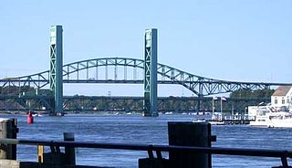
Badger's Island is located in the Piscataqua River at Kittery, Maine, directly opposite Portsmouth, New Hampshire. It carries U.S. Route 1 between the states, connecting to the Kittery mainland by the Badger's Island Bridge, and to New Hampshire by the Memorial Bridge. Now largely a suburb of Portsmouth, the island features houses, condominiums, restaurants and marinas.

William Badger (shipbuilder) American shipbuilder

William Badger was a master shipbuilder operating in Kittery, Maine, United States who built more than 100 vessels.

Fort Foster (Kittery, Maine)

Fort Foster, now part of Fort Foster Park, is a historic fort active 1901-1946 on the southwest tip of Gerrish Island in the Kittery Point area of Kittery, Maine. The park includes beaches and trails. Battery Bohlen and Battery Chapin were the major parts of the fort.

Rice Public Library

The Rice Public Library is the public library of Kittery, Maine. It is located at 8 Wentworth Street in the central Kittery Foreside village, in an architecturally distinguished Romanesque Revival building built in 1889 and listed on the National Register of Historic Places in 1979, with a large annex just across the street at 2 Walker Street.

Mark F. and Eliza J. Wentworth House

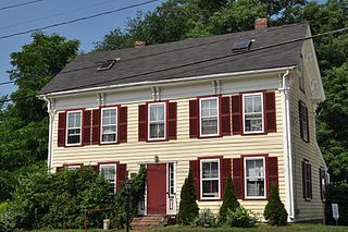
The Mark F. and Eliza J. Wentworth House is a historic house at 9 Wentworth Street in Kittery, Maine. Probably built in the second quarter of the 19th century and given Italianate styling c. 1866, it is notable for its association with Mark Fernald Wentworth, a distinguished physician and decorated veteran of the American Civil War. The house was listed on the National Register of Historic Places in 1998.

Portsmouth Downtown Historic District historic district in New Hampshire, USA

The Portsmouth Downtown Historic District encompasses the historic urban core of Portsmouth, New Hampshire. With a history dating to the 17th century, Portsmouth was New Hampshire's principal seaport and the center of its economy for many decades, and the architecture of its urban center is reflective of nearly four centuries of history. The district is roughly L-shaped, radiating from the downtown Market Square area to South Street in the south and Madison and Columbia streets in the west, with more than 1,200 historically significant buildings. It was listed on the National Register of Historic Places in 2017. The district includes 35 previous listings on the National Register, and five National Historic Landmarks.

References

  1. 1 2 3 Brockway, Lucinda; Masury, Ann (2012). NRHP nomination for Frank C. Frisbee Elementary School; available by request from the Maine SHPO