Kutaisi uezd

Last updated

Kutaisi uezd
Кутаисскій уѣздъ
Coat of arms of Kutais Governorate.svg
Kutaisi Uyezd of Kutaisi Governorate (1905-1917).png
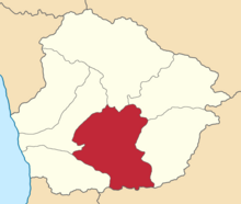
Location in the Kutaisi Governorate
Country Russian Empire
Viceroyalty Caucasus
Governorate Kutaisi
Established1846
Abolished1928
CapitalKutais
(present-day Kutaisi)
Area
  Total
2,324.65 km2 (897.55 sq mi)
Population
 (1916)
  Total
291,969
  Density130/km2 (330/sq mi)
   Urban
19.92%
   Rural
80.08%

The Kutaisi uezd [a] was a county ( uezd ) of the Kutaisi Governorate of the Caucasus Viceroyalty of the Russian Empire. It bordered the Akhaltsikhe uezd of the Tiflis Governorate to the south, the Ozurgeti and Senaki uezds to the west, the Lechkhumi and Racha uezds to the north, and the Shorapani uezd to the east. The area of the uezd corresponded to most of the contemporary Imereti region of Georgia. The Kutaisi uezd was eponymously named for its administrative center, Kutais (present-day Kutaisi). [1]

Contents

History

The Kutaisi uezd was formed in 1846 as part of the Kutaisi Governorate on the territory of the historical region of Imereti during the time of the Russian Empire. In 1918, the Kutaisi Governorate including the Kutaisi uezd was incorporated into the Democratic Republic of Georgia. [1]

Administrative divisions

The subcounties ( uchastoks ) of the Kutaisi uezd in 1913 were: [2]

Name1912 populationArea
Bagdadskiy uchastok (Багдадскій участокъ)52,7701,255.75 square versts (1,429.12  km2 ; 551.79  sq mi )
Kutaisskiy uchastok (Кутаисскій участокъ)37,791449.11 square versts (511.12  km2 ; 197.34  sq mi )
Samtredskiy uchastok (Самтредскій участокъ)49,629354.96 square versts (403.97  km2 ; 155.97  sq mi )
Tkvibulskiy uchastok (Тквибульскій участокъ)34,123544.74 square versts (619.95  km2 ; 239.36  sq mi )
Khonskiy uchastok (Хонскій участокъ)42,417438.08 square versts (498.56  km2 ; 192.50  sq mi )

Demographics

Russian Empire Census

According to the Russian Empire Census, the Kutaisi uezd had a population of 221,665 on 28 January [ O.S. 15 January] 1897, including 113,848 men and 107,817 women. The majority of the population indicated Imeretian to be their mother tongue, with significant Georgian and Russian speaking minorities: [3]

Linguistic composition of the Kutaisi uezd in 1897 [3]
LanguageNative speakers%
Imeretian 148,00366.77
Georgian 60,27827.19
Russian 4,0851.84
Jewish 3,6141.63
Mingrelian 1,7380.78
Armenian 1,3310.60
Ukrainian 6420.29
Polish 5310.24
Greek 3510.16
German 1610.07
Lithuanian 1460.07
Turkish 1090.05
Tatar [b] 720.03
Kazi-Kumukh 590.03
Ossetian 480.02
Svan 450.02
Persian 420.02
Abkhaz 290.01
Avar-Andean 280.01
Romanian 130.01
Belarusian 90.00
English 50.00
Estonian 40.00
Kurdish 10.00
Other3210.14
TOTAL221,665100.00

Kavkazskiy kalendar

According to the 1917 publication of Kavkazskiy kalendar , the Kutaisi uezd had a population of 291,969 on 14 January [ O.S. 1 January] 1916, including 156,683 men and 135,286 women, 273,021 of whom were the permanent population, and 18,948 were temporary residents: [6]

Nationality Urban Rural TOTAL
Number%Number%Number%
Georgians 33,84358.20230,86298.74264,70590.66
Jews 10,47918.022,2040.9412,6834.34
Russians 10,97518.876480.2811,6233.98
Armenians 1,8453.17930.041,9380.66
Asiatic Christians 6811.1700.006810.23
Other Europeans 2330.4010.002340.08
Shia Muslims [c] 950.16100.001050.04
TOTAL58,151100.00233,818100.00291,969100.00

Notes

  1. Before 1918, Azerbaijanis were generally known as "Tatars". This term, employed by the Russians, referred to Turkic-speaking Muslims of the South Caucasus. After 1918, with the establishment of the Azerbaijan Democratic Republic and "especially during the Soviet era", the Tatar group identified itself as "Azerbaijani". [4] [5]
  2. Primarily Tatars. [7]

References

  1. 1 2 Tsutsiev 2014.
  2. Кавказский календарь на 1913 год, pp. 160–167.
  3. 1 2 "Демоскоп Weekly - Приложение. Справочник статистических показателей". www.demoscope.ru. Retrieved 2022-06-27.
  4. Bournoutian 2018, p. 35 (note 25).
  5. Tsutsiev 2014, p. 50.
  6. Кавказский календарь на 1917 год, pp. 198–205.
  7. Hovannisian 1971, p. 67.

Bibliography

42°15′0″N42°42′0″E / 42.25000°N 42.70000°E / 42.25000; 42.70000