Nelson is a town in Buffalo County in the U.S. state of Wisconsin. The population was 571 at the 2010 census. The village of Nelson is located within the town. The unincorporated communities of Misha Mokwa and Trevino are located in the town. The unincorporated community of Urne is located partially in the town.

Midlands is a province of Zimbabwe. It has an area of 49,166 square kilometres (18,983 sq mi) and a population of 1,614,941 (2012). Gweru is the capital of the province. It is home to various peoples. As a central point in Zimbabwe it has a blend of Shona, Ndebele, Tswana, Suthu, Chewa among various other languages spoken in Zimbabwe.
The Washita River is a river in the states of Texas and Oklahoma in the United States. The river is 295 miles (475 km) long and terminates at its confluence with the Red River, which is now part of Lake Texoma on the Texas–Oklahoma border.

Borchgrevink Glacier is a large glacier in the Victory Mountains, Victoria Land, draining south between Malta Plateau and Daniell Peninsula, and thence projecting into Glacier Strait, Ross Sea, as a floating glacier tongue, the Borchgrevink Glacier Tongue, just south of Cape Jones. It was named by the New Zealand Geological Survey Antarctic Expedition, 1957–58, for Carsten Borchgrevink, leader of the British Antarctic Expedition, 1898–1900. Borchgrevink visited the area in February 1900 and first observed the seaward portion of the glacier.

Zhombe is a rural communal area in Kwekwe District, Midlands Province, Zimbabwe. There are a few commercial farms within its borders and a handful of resettlement areas. Most of it is within the Zhombe Constituency. Its administrative centre is the Zhombe Joel Growth Point, and it is under the Zibagwe Rural District Council.

Kwekwe District is a district in Zimbabwe.

Amizour is a town in northern Algeria of the Béjaïa Province.

The Rushikulya River is one of the major rivers in the state of Odisha and covers entire catchment area in the districts of Kandhamal and [[Ganjam] of Odisha. The Rushikulya originates at an elevation of about 1000 metres from Daringbadi hills of the Eastern Ghats range. The place from where the river originates, Daringbadi is called the ' Kashmir of Odisha '. The river lies within the geographical coordinates of 19.07 to 20.19 north latitude and 84.01 to 85.06 east longitude. It meets the Bay of Bengal at Puruna Bandha in Ganjam. Its tributaries are the Baghua, the Dhanei, the Badanadi etc. It has no delta as such at its mouth.

Boonoo Boonoo River, a watercourse of the Clarence River catchment, is located in the Northern Tablelands district of New South Wales, Australia.
The Ngezi River is a river in central Zimbabwe.
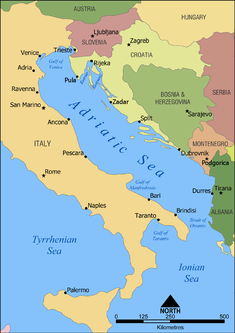
The Gulf of Manfredonia is a gulf on the east coast of Italy. It is part of the Adriatic Sea. The Monte Gargano peninsula forms the northern border of the gulf, and the Apulian coast forms the southern border. Several rivers flow into the gulf, including the Carapelle and the Cervaro. The gulf is named after the town Manfredonia. Areas along the coast include marshes such as the Saline di Margherita di Savoia.
Ngezi River may refer to:

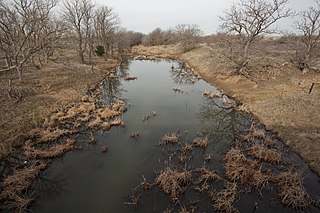
Ngondoma River is a river in Zhombe Communal Land, Kwekwe District in the Midlands province of Zimbabwe.
Kwekwe-Gokwe Highway or the R84-7 Highway is an all-weather bitumen macadam highway in Zimbabwe running from Kwekwe to Gokwe passing through Zhombe. as a trunk road it is officially the P11 Highway
Globe and Phoenix Mine is a gold mine in Zimbabwe. It is just outside Kwekwe CBD.
The Gaika Mine, now known as the Gaika Gold Fields, is situated in what was Chicago Farm just about 2 kilometres (1.2 mi) south of Kwekwe CBC. The Gaika Mine was the earliest mine developed in 1894, then Globe and Phoenix in 1895-1900, the Eldorado in 1905, the Antelope in 1908, the Cam and Motor Mine in 1909, the Shamva Mine in 1909-1910, and numerous others during the period 1895-1911.
Prag Lalloo Naran was a Zimbabwean politician and businessman recognized as a "Nationalist for the struggle for Zimbabwe’s independence," and a "leading member of the (Zimbabwe) Asian Community".

