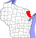
Lake, Marinette County, Wisconsin

Last updated

Lake, Wisconsin
WIMap-doton-Lake.png
Location of Lake, Wisconsin
Coordinates: 45°12′3″N87°53′13″W / 45.20083°N 87.88694°W / 45.20083; -87.88694
Country Flag of the United States.svg  United States
State Flag of Wisconsin.svg  Wisconsin
County Marinette
Area
  Total59.5 sq mi (154.2 km2)
  Land55.8 sq mi (144.4 km2)
  Water3.8 sq mi (9.8 km2)
Elevation
[1]
699 ft (213 m)
Population
 (2000)
  Total1,064
  Density19.1/sq mi (7.4/km2)
Time zone UTC-6 (Central (CST))
  Summer (DST) UTC-5 (CDT)
FIPS code 55-41075 [2]
GNIS feature ID1583508 [1]

Lake is a town in Marinette County, Wisconsin, United States. As of the 2000 census, the town population was 1,064. The unincorporated community of Loomis is located in the town,

Contents

Geography

According to the United States Census Bureau, the town has a total area of 59.5 square miles (154.2 km2), of which, 55.8 square miles (144.4 km2) of it is land and 3.8 square miles (9.8 km2) of it (6.35%) is water.

Demographics

As of the census [2] of 2000, there were 1,064 people, 418 households, and 318 families residing in the town. The population density was 19.1 inhabitants per square mile (7.4/km2). There were 524 housing units at an average density of 9.4 per square mile (3.6/km2). The racial makeup of the town was 97.65% White, 0.19% African American, 0.56% Native American, 0.09% Asian, 0.38% from other races, and 1.13% from two or more races. Hispanic or Latino of any race were 0.66% of the population.

There were 418 households, out of which 28.7% had children under the age of 18 living with them, 66.7% were married couples living together, 5.5% had a female householder with no husband present, and 23.7% were non-families. 20.1% of all households were made up of individuals, and 8.6% had someone living alone who was 65 years of age or older. The average household size was 2.55 and the average family size was 2.93.

In the town, the population was spread out, with 23.3% under the age of 18, 6.3% from 18 to 24, 27.5% from 25 to 44, 28.0% from 45 to 64, and 14.8% who were 65 years of age or older. The median age was 42 years. For every 100 females, there were 106.2 males. For every 100 females age 18 and over, there were 106.6 males.

The median income for a household in the town was $39,432, and the median income for a family was $44,615. Males had a median income of $35,795 versus $24,844 for females. The per capita income for the town was $17,518. About 6.3% of families and 8.4% of the population were below the poverty line, including 16.8% of those under age 18 and 6.3% of those age 65 or over.

Related Research Articles

<span class="mw-page-title-main">Patoka, Indiana</span> Town in Indiana, United States

Patoka is the fourth largest town and sixth largest community in Gibson County, Indiana, United States. The population was 735 at the 2010 census.

<span class="mw-page-title-main">Vienna, Maine</span> Town in the state of Maine, United States

Vienna is a town in Kennebec County, Maine, United States. The population was 578 at the 2020 census.

Cascade Township is a township in Olmsted County, Minnesota, United States. The population was 3,183 at the 2000 census.

<span class="mw-page-title-main">Darien, New York</span> Town in Genesee County, New York

Darien is a town in Genesee County, New York, United States. The population was 3,010 at the 2020 census. Darien lies in the southwestern part of Genesee County, southwest of Batavia.

<span class="mw-page-title-main">Lincoln Park, New York</span> CDP in New York, United States

Lincoln Park is a hamlet in Ulster County, New York, United States. The population was 2,545 at the 2020 census.

<span class="mw-page-title-main">Byesville, Ohio</span> Village in Ohio, United States

Byesville is a village in Guernsey County, Ohio, United States, along Wills Creek. The population was 2,364 at the 2020 census.

<span class="mw-page-title-main">Frankfort, Ohio</span> Village in Ohio, United States

Frankfort is a village in Ross County, Ohio, United States, along the North Fork of Paint Creek. The village is located in Concord Township. The population was 1,084 at the 2020 census.

<span class="mw-page-title-main">West Logan, West Virginia</span> Town in West Virginia, United States

West Logan is a town along the Guyandotte River in Logan County, West Virginia, United States. The population was 400 at the 2020 census. For unknown reasons, some sources report West Logan to lay west of the county seat at Logan, attributing to this fact the name.

<span class="mw-page-title-main">Mason, West Virginia</span> Town in West Virginia, United States

Mason, also known as Mason City, is a town in Mason County, West Virginia, United States. The population was 865 at the 2020 census. It is part of the Point Pleasant, WV–OH Micropolitan Statistical Area.

<span class="mw-page-title-main">Anawalt, West Virginia</span> Town in West Virginia, United States

Anawalt is a town in McDowell County, West Virginia, United States. At one time it was known as Jeanette. It is named in honor of James White Anawalt, who was then manager of Union Supply Company, a subsidiary of the United States Steel Company. The population was 186 at the 2020 census. Coal mining was the town's chief industry.

<span class="mw-page-title-main">Montrose, Wisconsin</span> Town in Wisconsin, United States

The Town of Montrose is located in Dane County, Wisconsin, United States. The population was 1,134 at the 2000 census. The unincorporated communities of Basco and Paoli are located within the town.

<span class="mw-page-title-main">Summit, Douglas County, Wisconsin</span> Town in Wisconsin, United States

Summit is a town in Douglas County, Wisconsin, United States. The population was 1,042 at the 2000 census. The unincorporated communities of Chaffey, Foxboro, and Patzau are located in the town.

<span class="mw-page-title-main">Nashville, Wisconsin</span> Town in Wisconsin, United States

Nashville is a town in Forest County, Wisconsin, United States. The population was 1,064 at the 2010 census. The Mole Lake Indian Reservation is located within the town. The town is named after G.V. Nash of Forest City, Arkansas.

<span class="mw-page-title-main">Apple River, Wisconsin</span> Town in Wisconsin, United States

The Town of Apple River is located in Polk County, Wisconsin, United States. The population was 1,067 at the 2000 census. The unincorporated community of Range is located partially in the town.

<span class="mw-page-title-main">Johnstown, Polk County, Wisconsin</span> Town in Wisconsin, United States

Johnstown is a town in Polk County, Wisconsin, United States. The population was 520 at the 2000 census.

<span class="mw-page-title-main">Buena Vista, Portage County, Wisconsin</span> Town in Wisconsin, United States

Buena Vista is a town in Portage County, Wisconsin, United States. The population was 1,198 at the 2010 census. The unincorporated communities of Coddington and Keene are located within the town.

<span class="mw-page-title-main">Ranchester, Wyoming</span> Town in Wyoming, United States

Ranchester is a town in Sheridan County, Wyoming, United States. The population was 1,064 at the 2020 census.

<span class="mw-page-title-main">Raven, Virginia</span> CDP in Virginia, United States

Raven is a census-designated place (CDP) in Russell and Tazewell counties in the U.S. state of Virginia. The population was 2,270 at the 2010 census.

Ellsworth is a town in Pierce County, Wisconsin, United States. The population was 1,064 at the 2000 census. The Village of Ellsworth is located within the town. The unincorporated community of Lawton is also located partially in the town.

<span class="mw-page-title-main">Mountainair, New Mexico</span> Town in New Mexico, United States

Mountainair is a town in Torrance County, New Mexico, United States. It was founded in 1902 by John Corbett, Colonel E. C. Manning, and Elias S. Stover. The population was 884 at the 2020 census. It is part of the Albuquerque Metropolitan Statistical Area. The main visitor center for Salinas Pueblo Missions National Monument is located within the town.

References

  1. 1 2 "US Board on Geographic Names". United States Geological Survey. October 25, 2007. Retrieved January 31, 2008.
  2. 1 2 "U.S. Census website". United States Census Bureau . Retrieved January 31, 2008.