
Armory Square is a small neighborhood on the west side of Downtown Syracuse, New York. It began life as a busy commercial and industrial area just to the west of the central city. After World War II, Syracuse's central city became less and less populated as more housing and business facilities were built in the suburbs. In the 1980s, plans were first made to transform the languishing district into a small shopping/arts/nightlife district surrounding the former Syracuse Armory. These plans came to fruition during the 1990s, when new stores and restaurants opened, and several new buildings were constructed in a compatible style to the middle and late 1800s and early 1900s architecture dominating the district.

The National Register of Historic Places in the United States is a register including buildings, sites, structures, districts, and objects. The Register automatically includes all National Historic Landmarks as well as all historic areas administered by the U.S. National Park Service. Since its introduction in 1966, more than 97,000 separate listings have been added to the register.
Kenton is a neighborhood in the north section of Portland, Oregon, United States. The neighborhood was originally a company town founded in 1911 for the Swift Meat Packing Company.
This is a list of properties and historic districts in Washington that are listed on the National Register of Historic Places. There are at least three listings in each of Washington's 39 counties.
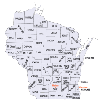
This is a list of properties and districts listed on the National Register of Historic Places in Wisconsin. There are over 2,500 listed sites in Wisconsin. Each of the state's 72 counties has at least one listing on the National Register.

Buildings, sites, districts, and objects in Virginia listed on the National Register of Historic Places:

This is a list of properties and districts listed on the National Register of Historic Places in Pennsylvania. As of 2015, there are over 3,000 listed sites in Pennsylvania. All 67 counties in Pennsylvania have listings on the National Register.
Benson is a historic neighborhood in Omaha, Nebraska. Now a pocket within North Omaha, Benson Place was originally platted in 1887 and was annexed into the City of Omaha in 1917. Actor Nick Nolte lived in the Benson area before moving to the Westside district.
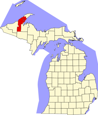
This is a list of the National Register of Historic Places listings in Houghton County, Michigan.

The boundary markers of the original District of Columbia are the 40 milestones that marked the four lines forming the boundaries between the states of Maryland and Virginia and the square of 100 square miles (259 km2) of federal territory that became the District of Columbia in 1801. Working under the supervision of three commissioners that President George Washington had appointed in 1790 in accordance with the federal Residence Act, a surveying team led by Major Andrew Ellicott placed these markers in 1791 and 1792. Among Ellicott's assistants were his brothers Joseph and Benjamin Ellicott, Isaac Roberdeau, George Fenwick, Isaac Briggs and an African American astronomer, Benjamin Banneker.

Downtown Grand Forks is the original commercial center of Grand Forks, North Dakota, United States. Located on the western bank of the Red River of the North, the downtown neighborhood is situated near the fork of the Red River and the Red Lake River. While downtown is no longer the dominant commercial area of the Greater Grand Forks community, it remains the historic center of Grand Forks. An 80.4-acre (32.5 ha) portion was listed on the National Register of Historic Places in 2005, as Downtown Grand Forks Historic District. Today, downtown Grand Forks is home to many offices, stores, restaurants, and bars.

Downtown Columbia is the central business, government, and social core of Columbia, Missouri and the Columbia Metropolitan Area. Three colleges — the University of Missouri, Stephens College, and Columbia College — all border the area. Downtown Columbia is an area of approximately one square mile surrounded by the University of Missouri on the south, Stephens College to the east, and Columbia College on the north. The area serves as Columbia's financial and business district and is the topic of a large initiative to draw tourism, which includes plans to capitalize on the area's historic architecture and Bohemian characteristics. The downtown skyline is relatively low and is dominated by the 10-story Tiger Hotel, built in 1928, and the 15-story Paquin Tower.
Winnona Park is a historic area in the southeast corner of the Atlanta, Georgia suburb of Decatur. It is listed as a historic district on the National Register of Historic Places, but it is not one of the City of Decatur's locally designated historic districts.

The following outline is provided as an overview of and topical guide to the U.S. state of Oregon:

The Downtown Albany Historic District is a 19-block, 66.6-acre (27.0 ha) area of Albany, New York, United States, centered on the junction of State and North and South Pearl streets. It is the oldest settled area of the city, originally planned and settled in the 17th century, and the nucleus of its later development and expansion. In 1980 it was designated a historic district by the city and then listed on the National Register of Historic Places.

Joseph A. Shannon (1859-1934), known in at least one source as John A. Shannon, was an architect in Devils Lake, North Dakota.

Upper Main Street Historic District is a national historic district located at Lafayette, Tippecanoe County, Indiana. Sixth Street was the City of Lafayette's eastern boundary when it was originally platted. By 1840, the boundary was extended to include Lake Erie and Wabash Railroad at Eleventh Street. This area became the cities commercial center. Businesses around Eleventh Street developed to meet the traveling publics needs. The Enterprise Hotel, at 1015 Main Street, as well as the Alt Heidelberg, American Lafayette and the Derby Hotel were early established by 1899.

The North Street Historic District encompasses the traditional commercial area serving the residential Old North End neighborhood of Burlington, Vermont. It extends for ten blocks along North Street between North Avenue and North Winooski Avenue, and has served as the neighborhood's commercial center for over 150 years. It was listed on the National Register of Historic Places in 2001.

The Haymarket Commercial Historic District is a nationally recognized historic district located in Council Bluffs, Iowa, United States. It was listed on the National Register of Historic Places in 1985. At the time of its nomination the district consisted of 28 resources, including 19 contributing buildings, and nine non-contributing buildings. "Haymarket" is the forked-junction of Main and Pearl Streets where the city's scales were located in the 1890s. It is on the south side of the central business district. Council Bluffs was founded in the late 1840s as Kanesville by Mormons. When Brigham Young called all people of the faith outside of Utah to Salt Lake City in 1852, the community ceased to be majority Mormon. It was renamed Council Bluffs in 1853. The buildings here are among the earliest extant commercial buildings in the city.

The Portsmouth Downtown Historic District encompasses the historic urban core of Portsmouth, New Hampshire. With a history dating to the 17th century, Portsmouth was New Hampshire's principal seaport and the center of its economy for many decades, and the architecture of its urban center is reflective of nearly four centuries of history. The district is roughly L-shaped, radiating from the downtown Market Square area to South Street in the south and Madison and Columbia streets in the west, with more than 1,200 historically significant buildings. It was listed on the National Register of Historic Places in 2017. The district includes 35 previous listings on the National Register, and five National Historic Landmarks.


