The Illinois and Michigan Canal connected the Great Lakes to the Mississippi River and the Gulf of Mexico. In Illinois, it ran 96 miles (154 km) from the Chicago River in Bridgeport, Chicago to the Illinois River at LaSalle-Peru. The canal crossed the Chicago Portage, and helped establish Chicago as the transportation hub of the United States, before the railroad era. It was opened in 1848. Its function was partially replaced by the wider and deeper Chicago Sanitary and Ship Canal in 1900, and it ceased transportation operations with the completion of the Illinois Waterway in 1933.

Lake County is situated in the northeastern corner of the U.S. state of Illinois, along the shores of Lake Michigan. As of the 2020 census, it has a population of 714,342, making it the third-most populous county in Illinois. Its county seat is Waukegan, the tenth-largest city in Illinois. The county is primarily suburban, with some urban areas and some rural areas. Due to its location, immediately north of Cook County, Lake County is one of the collar counties of the Chicago metropolitan area. Its northern boundary is the Wisconsin state line.

Barrington is a village in Cook County and Lake County, Illinois, United States. The population was 10,722 at the 2020 census. A northwest suburb of Chicago, the area features wetlands, forest preserves, parks, and horse trails in a country-suburban setting.
Oak Park is a village in Cook County, Illinois, adjacent to Chicago. It is the 26th-most populous municipality in Illinois with a population of 54,583 as of the 2020 U.S. Census estimate. Oak Park was first settled in 1835 and later incorporated in 1902, when it separated from Cicero. It is closely tied to the smaller town of River Forest, Illinois sharing Oak Park and River Forest High School. Architect Frank Lloyd Wright and his wife settled in Oak Park in 1889, and his work heavily influenced local architecture and design, including the Frank Lloyd Wright Home and Studio. Over the years, rapid development was spurred by railroads and street cars connecting the village to jobs in nearby Chicago. In 1968, Oak Park passed the Open Housing Ordinance, which helped devise strategies to integrate the village rather than resegregate.

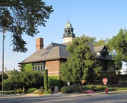
Lake Forest is a city located in Lake County, Illinois, United States. Per the 2020 census, the population was 19,367. The city is along the shore of Lake Michigan, and is a part of the Chicago metropolitan area and the North Shore. Lake Forest was founded with Lake Forest College and was laid out as a town in 1857, a stop for travelers making their way south to Chicago. The Lake Forest City Hall, designed by Charles Sumner Frost, was completed in 1898. It originally housed the fire department, the Lake Forest Library, and city offices.

Mettawa is a village in Lake County, Illinois, United States. Per the 2020 census, the population was 533. The village maintains trails for pedestrian, bicycle and equestrian usage. Five forest preserves of the Lake County Forest Preserve District are located within village boundaries.

Lakeview, also spelled Lake View, is one of the 77 community areas of Chicago, Illinois. Lakeview is located in the city's North Side. It is bordered by West Diversey Parkway on the south, West Irving Park Road on the north, North Ravenswood Avenue on the west, and the shore of Lake Michigan on the east. The Uptown community area is to Lakeview's north, Lincoln Square to its northwest, North Center to its west, and Lincoln Park to its south. The 2020 population of Lakeview was 103,050 residents, making it the second-largest Chicago community area by population.

The Near South Side is a community area of Chicago, Illinois, United States, just south of the downtown central business district, the Loop. The Near South Side's boundaries are as follows: North—Roosevelt Road ; South—26th Street; West—Chicago River between Roosevelt and 18th Street, Clark Street between 18th Street and Cermak Road, Federal between Cermak Road and the Stevenson Expressway just south of 25th Street, and Clark Street again between the Stevenson and 26th Street; and East—Lake Michigan.

The Old Chicago Water Tower District is a historic district along the Magnificent Mile shopping district in the Near North Side community area of Chicago, Illinois. The district is located on both sides of North Michigan Avenue between East Chicago and East Pearson Streets. It includes the Chicago Water Tower, Chicago Avenue Pumping Station, and Chicago Fire Department Fire Station No. 98. All three structures are part of the Chicago Landmark district designated on October 6, 1971. The Water Tower and Pumping Station were jointly added to the National Register of Historic Places on April 23, 1975. In addition the Tower was named an American Water Landmark in 1969. The Water Tower was also one of the few buildings to survive the Great Chicago Fire. The district is the namesake of the nearby Water Tower Place.

Pullman National Historical Park is a historic district now located in Chicago, which in the 19th century was the first model, planned industrial community in the United States. The district had its origins in the manufacturing plans and organization of the Pullman Company and became one of the most well-known company towns in the United States, as well as the scene of the violent 1894 Pullman strike. It was built for George Pullman as a place to produce the famous Pullman railroad-sleeping cars.

The Chicago Portage National Historic Site is a National Historic Site commemorating the importance of the Chicago Portage in Lyons, Cook County, Illinois, United States. It is located in Chicago Portage Forest Preserve and the Ottawa Trail Woods Forest Preserve, at the junction of Portage Creek with the Des Plaines River, on the west side of Harlem Avenue on the line of 48th Street. Preserved within the park is the western end of the historic portage linking the Chicago River to the Des Plaines River, thereby linking the Great Lakes to the Mississippi River. A memorial depicting the portage of French explorers is located at the parking area. A trail leads from the memorial down into the portage wilderness area.

Loop Retail Historic District is a shopping district within the Chicago Loop community area in Cook County, Illinois, United States. It is bounded by Lake Street to the north, Ida B. Wells Drive to the south, State Street to the west and Wabash Avenue to the east. The district has the highest density of National Historic Landmark, National Register of Historic Places and Chicago Landmark designated buildings in Chicago. It hosts several historic buildings including former department store flagship locations Marshall Field and Company Building, and the Sullivan Center. It was added to the National Register of Historic Places on November 27, 1998. It includes 74 contributing buildings and structures, including 13 separately listed Registered Historic Places, and 22 non-contributing buildings. Other significant buildings in the district include the Joffrey Tower, Chicago Theatre, Palmer House, and Page Brothers Building. It also hosts DePaul University's College of Commerce, which includes the Kellstadt Graduate School of Business and the Robert Morris College.

The following is an alphabetical list of articles related to the U.S. state of Illinois.

The Gold Coast Historic District is a historic district in Chicago, Illinois. Part of Chicago's Near North Side community area, it is roughly bounded by North Avenue, Lake Shore Drive, Oak Street, and Clark Street.

La Fox is an unincorporated community in Blackberry Township, Kane County, Illinois, United States. The community is located four miles west of Geneva and five miles east of Elburn. It serves as a station on Metra's Union Pacific/West Line.

The Logan Square Boulevards Historic District is a linear historic district in the Logan Square community area of North Side, Chicago. It encompasses 2.5 miles (4.0 km) of the Chicago boulevard system.

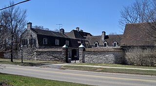
The Philip H. Sheridan Reserve Center is the former Fort Sheridan now in Lake Forest, Highwood, and Highland Park in Lake County, Illinois, United States. It was originally established as a United States Army Post named after Civil War Cavalry General Philip Sheridan, to honor his services to Chicago. When the main fort was officially closed by the Army on May 3, 1993, the majority of the property was sold by the Department of Defense to commercial land developers. Most of the original housing structures were then refurbished and resold as a residential community. Other buildings were given to cultural organizations like Midwest Young Artists, the largest youth music program in the Midwest. Approximately 90 acres (36 ha) of the southern end of the original post were retained by the Army; there the Army now operates the Sheridan Reserve Center complex.
The Green Bay Road Historic District is a residential historic district in Lake Forest, Illinois. Centered on Green Bay Road, a historic postal and military road that once connected Chicago with Green Bay, Wisconsin, the district includes 147 contributing buildings. The houses in the district are mainly country estates built in the late nineteenth and early twentieth century for some of the Chicago area's wealthiest residents. The Onwentsia Club, a country club to which most of the district's residents belonged, was the center of the area's social life and is also part of the district. The district includes works by several prominent Chicago architects, including Howard Van Doren Shaw, David Adler, Ambrose Coghill Cramer, and Chester Howe Walcott. While the Arts and Crafts style preferred by Shaw is common in the district, most of the other houses are designed in revival styles, including Classical Revival, Renaissance Revival, Colonial Revival, and Tudor Revival.
The West Park Neighborhood Historic District is a residential historic district surrounding West Park in Lake Forest, Illinois. The district includes 149 contributing buildings, most of which were built between 1907 and 1930, and West Park. Originally known as the Green Bay Addition, the neighborhood was planned in 1907 as the equivalent of a company town for the service workers at Lake Forest's many estates. Lake Forest was a popular home for the Chicago area's most wealthy residents in the early twentieth century, who typically built large estates that required teams of support workers to maintain. Architect Howard Van Doren Shaw, who also designed many of the estates, planned the neighborhood. While Shaw intended for the development to mainly use Tudor Revival architecture, few houses were designed in the style; the Colonial Revival, Folk Victorian, Craftsman, and American Foursquare styles were more common.