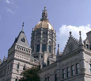
The neighborhoods of Hartford, Connecticut in the United States are varied and historic.

The Cheney Brothers Historic District was a center of the silk industry in Manchester, Connecticut, in the late 19th and early 20th century. The 175-acre (71 ha) district includes over 275 mill buildings, workers houses, churches, schools and Cheney family mansions. These structures represent the well-preserved company town of the Cheney Brothers silk manufacturing company, the first America-based silk company to properly raise and process silkworms, and to develop the difficult techniques of spinning and weaving silk. The area was declared a National Historic Landmark in 1978.
The Pine Meadow Historic District encompasses most of the historic 19th-century village of Pine Meadow in New Hartford, Connecticut. Located at a bend in the West Branch of the Farmington River southeast of New Hartford center, it is a well-preserved example of a rural industrial village. The district was listed on the National Register of Historic Places in 1996.

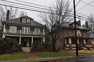
The West End South Historic District encompasses a neighborhood of mid 19th to early 20th century residential architecture in western Hartford, Connecticut and eastern West Hartford, Connecticut. Roughly bounded by Prospect and South Whitney Streets, West Boulevard, and Farmington Avenue, the area includes a large number of Colonial Revival and Queen Anne houses, as well as numerous buildings in other period styles, with only a small number of losses. It was listed on the National Register of Historic Places in 1985.

The Dwight Street Historic District is an irregularly shaped 135-acre (55 ha) historic district in New Haven, Connecticut. The district is located immediately west of the center of Downtown New Haven and is generally bounded by Elm Street on the north, Park Street on the east, North Frontage Road on the south, and Sherman Avenue on the west. It contains one of the city's highest concentrations of well-preserved 19th and early 20th-century residential architecture, much of which was developed for the working classes in the city's factories. It was listed on the National Register of Historic Places in 1983. The historic district includes most of the Dwight neighborhood and several blocks of the northeast corner of the West River neighborhood.

The house at 36 Forest Street, sometimes called the Burton House in Hartford, Connecticut, United States, is a wooden Shingle Style structure built in the late 19th century and largely intact today. It was listed on the National Register of Historic Places in 1983.

Nook Farm is a historical neighborhood in the Asylum Hill section on the western edge of Hartford, Connecticut, USA.
The Allen Place–Lincoln Street Historic District encompasses a small neighborhood of late 19th-century housing built for white-collar service workers in southern Hartford, Connecticut. It is roughly bounded by Madison, Washington, and Vernon Streets, and Zion Hill Cemetery, and has well-preserved examples of vernacular Queen Anne and Colonial Revival architecture. It was listed on the National Register of Historic Places in 2003.

The Asylum Avenue District encompasses the institutional core of the Asylum Hill neighborhood of Hartford, Connecticut. Located just west of Downtown Hartford across Interstate 84, it includes four churches, a school, and a handful of adjacent 19th-century residences. It was listed on the National Register of Historic Places in 1979.

The Central Avenue-Center Cemetery Historic District encompasses part of the town center of East Hartford, Connecticut. Although it was founded in the mid-17th century, it is now dominated by architecture of the late 19th and early 20th centuries. The Center Cemetery is the town's oldest surviving property, and includes the grave of William Pitkin, a colonial governor. The district, including portions of Main Street and Central Avenue, was listed on the National Register of Historic Places in 1993.

The Imlay and Laurel Streets District is a residential historic district on portions of Imlay, Laurel, Hawthorn and Sigourney Streets in Hartford, Connecticut. The area is a densely built residential neighborhood developed between about 1870 and 1895, with predominantly brick Italianate and Queen Anne construction. The district was listed on the National Register of Historic Places in 1979.

The James Pratt Funeral Service was a historic house at 69 Farmington Avenue in Hartford, Connecticut. Built in 1860, it was one of the few surviving mid-19th-century houses on a once-residential stretch of that street. The house was listed on the National Register of Historic Places in 1979. It was subsequently demolished, and the property is now part of the Aetna campus.

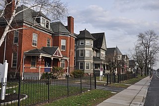
The Jefferson-Seymour District is a historic district encompassing a residential area on the south side of Hartford, Connecticut. Covering portions of Cedar, Wadsworth, Seymour and Jefferson Streets, it contains a well-preserved collection of late 19th and early 20th-century middle-class residential architecture, primarily executed in brick. It was listed on the National Register of Historic Places in 1979.
The Little Hollywood Historic District encompasses a concentrated collection of apartment buildings built mainly between the world wars in the West End neighborhood of Hartford, Connecticut. Located on Farmington Avenue and Owen, Frederick, and Denison Streets, they were built primarily to attract single tenants seeking small apartments, a trend that developed after World War I and ended after World War II. The district was listed on the National Register of Historic Places in 1982.

The West End North Historic District encompasses a neighborhood of late 19th and early 20th century residential architecture in western Hartford, Connecticut and eastern West Hartford, Connecticut. Roughly bounded by Prospect, Elizabeth, and Lorraine Streets and Farmington Avenue, the area includes a large number of Colonial Revival and Queen Anne houses, as well as numerous buildings in other period styles, with only a small number of losses. It was listed on the National Register of Historic Places in 1985.
The Oxford-Whitney Streets District is a historic district encompassing an early-20th century residential area in the West End neighborhood of Hartford, Connecticut. It extends along the east side of Oxford Street between Elizabeth and Cone Streets, and along the west side of Whitney between Fern and Elizabeth, and includes the north side of Fern Street between Whitney and Oxford. Most of the housing, a combination of single and multi-family residences, was built between 1906 and 1919, a period later than the surrounding areas, and is predominantly Colonial Revival in character. It was listed on the National Register of Historic Places in 2010.
The Parkside Historic District encompasses a fine collection of Queen Anne Victorian houses lining the east side of Wethersfield Avenue north of Wawarme Avenue in southern Hartford, Connecticut. This area was developed in the 1880s and 1890s by Mrs. Elizabeth Jarvis Colt, widow of arms manufacturer Samuel Colt, out of a portion of their extensive estate. Of this development, a row of nine houses now remains; it was listed on the National Register of Historic Places in 1984.

The Signourney Square Historic District encompasses a neighborhood in the Asylum Hill area of Hartford, Connecticut, United States, that was almost entirely built out in a single decade at the end of the 19th century as a middle-class residential area. It is roughly bounded by Garden, Ashley, and Woodland Streets on the east, south, and west, and by railroad tracks north of Sargeant Street to the north. The area retains much of its late 19th-century character, with relatively few modern intrusions. It was listed on the National Register of Historic Places in 1979, with small additions in 1983 and 2011.
The Sisson-South Whitney Historic District encompasses a neighborhood in the West End area of Hartford, Connecticut, that was built out between 1890 and 1930 as a streetcar suburb. It is roughly bounded by Farmington Avenue, South Whitney Street, West Boulevard, and Sisson Avenue, and includes a diversity of residential and commercial architecture, reflective of its initial development and subsequent growth. The district was listed on the National Register of Historic Places in 2013.

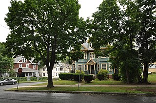
The Upper Albany Historic District encompasses a predominantly residential area of the North End of Hartford, Connecticut. It extends along Albany Avenue between Garden and Woodland Streets, including side streets to the south, and extends northward to include the southern portion of Keney Park. This area was developed in the first two decades of the 20th century, and has a fine array of period middle-class housing in the Queen Anne and Colonial Revival styles. It was listed on the National Register of Historic Places in 1986.


