
Lebanon is a city in St. Clair County, Illinois, United States. The population was 4,418 at the 2010 census and had decreased to an estimated 4,256 as of 2018. Like many other places in "Little Egypt" or Southern Illinois, Lebanon was named after the Eastern Mediterranean country of the same name. It is a part of the Metro-East region of the Greater St. Louis metropolitan area.

Lebanon (/ˈlɛbnən/) is a city in and the county seat of Boone County, Indiana, United States. The population was 15,792 at the 2010 census. Lebanon is located in central Indiana, approximately 29 miles (47 km) northwest of downtown Indianapolis and 36 miles (58 km) southeast of Lafayette.

The Financial District of Lower Manhattan, also known as FiDi, is a neighborhood located on the southern tip of Manhattan in New York City. It is bounded by the West Side Highway on the west, Chambers Street and City Hall Park on the north, Brooklyn Bridge on the northeast, the East River to the southeast, and South Ferry and the Battery on the south.
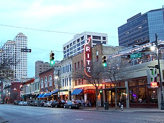
Sixth Street is a historic street and entertainment district in Austin, Texas, located within the city's urban core in downtown Austin. Sixth Street was formerly named Pecan Street under Austin's older naming convention, which had east–west streets named after trees and north–south streets named after Texas rivers.

Ladd's Addition is an inner southeast historic district of Portland, Oregon, United States. It is Portland's oldest planned residential development, and one of the oldest in the western United States. The district is known in Portland for a diagonal street pattern, which is at odds with the rectilinear grid of the surrounding area. Roughly eight blocks (east-west) by ten blocks (north-south) in size, Ladd's is bordered by SE Hawthorne, Division, 12th, and 20th streets. It is part of the Hosford-Abernethy neighborhood association.

Old City is a neighborhood in Center City, Philadelphia, Pennsylvania, United States, near the Delaware River waterfront. It is home Independence National Historical Park, a dense section of historic landmarks including Independence Hall, the Liberty Bell, the First Bank of the United States, the Second Bank of the United States, and Carpenters' Hall. It also includes historic streets such as Elfreth's Alley, dating back to 1703.
Barry Historic District is a historic district comprising the commercial and older residential areas of Barry, Pike County, Illinois. Barry was founded as an agricultural community in the 1830s, and most of its development took place between its founding and the Civil War. The city's commercial core, however, was mainly built in 1894 after a fire destroyed most of the existing commercial buildings. The 1894 buildings are well-preserved examples of typical commercial architecture of the period, and several have metal storefronts. The district also includes Barry's "Diamond Hill" residential district on Mortimer Street east of Brown Street and several other residential sections. Prominent architectural styles in the residential areas include Italianate, Queen Anne, Carpenter Gothic, and vernacular types from the late 19th century.

Griggsville Historic District is a historic district comprising the oldest sections of the city of Griggsville, Pike County, Illinois. The district encompasses Griggsville's commercial center and two of its residential areas. Development began in the commercial center in the 1830s; however, most of its significant buildings were built between 1850 and 1880. These buildings are mainly two-story brick structures, and several have Italianate influences. The southern residential area also has a heavy Italianate influence, as most of the homes there are designed in the style. The northwest residential area includes a variety of architectural styles and has a more rural character.

The Belleville Historic District is a historic district in Belleville, Illinois. The primarily residential district consists of an irregularly shaped area on the east side of Belleville. 70 buildings are included in the district, all of which are contributing buildings to its historic character. The homes in the district represent Belleville's residential development from 1830 to 1900. Many of the houses were designed in a vernacular cottage style popular among the city's German immigrants; while common in Belleville and other Metro-East cities, the style is little seen elsewhere in the state. Formal architectural styles such as Greek Revival and Italianate are also prevalent in the district.

The Central City/Black Hawk Historic District is a National Historic Landmark District that encompasses the developed areas of Central City and Black Hawk, Colorado, United States. They are adjacent former gold mining camps in the Front Range of the Rocky Mountains in Gilpin County, Colorado. For a time, the area was known as the Richest Square Mile on Earth, and was the largest urban area of the Colorado Territory in the 1870s.

The Ste. Genevieve National Historical Park, established in 2020, consists of part or the whole of the area of the Ste. Genevieve Historic District, which is a historic district encompassing much of the built environment of Ste. Genevieve, Missouri, United States. The city was in the late 18th century the capital of Spanish Louisiana, and, at its original location a few miles south, capital of French Louisiana as well. A large area of the city, including fields along the Mississippi River, is a National Historic Landmark District designated in 1960, for its historically French architecture and land-use patterns, while a smaller area, encompassing the parts of the city historically important between about 1790 and 1950, was named separately to the National Register of Historic Places in 2002.
The Colburn Park Historic District encompasses the heart of Lebanon, New Hampshire. It consists of Colburn Park, a large rectangular park in the center of the city, the buildings that are arrayed around it, and several 19th century buildings that are immediately adjacent to those. The district covers 12 acres (4.9 ha), and was listed on the National Register of Historic Places in 1986.

The Lower Village District encompasses a historic industrial area down the Sugar River a short way from the historic center of Claremont, New Hampshire. The area was developed beginning in the 1830s by the Claremont Mill Company, and extends on either side of the river roughly from the Main Street crossing in the west to the junction of Main and Central Streets.
Shiloh Historic District is a historic area of downtown Springdale, Arkansas listed on the National Register of Historic Places. The district encompasses eighteen significant buildings within its 32 acres (13 ha), with eight having historic or architectural significance and twelve relating to the early commercial and industrial development of Springdale. Also included within the area are several roads of historic significance to the city. The district covers an area straddling Spring Brook, around which the community developed beginning in the 1830s, and is roughly centered on the 1870 Shiloh Church building, which is the community's oldest surviving building.
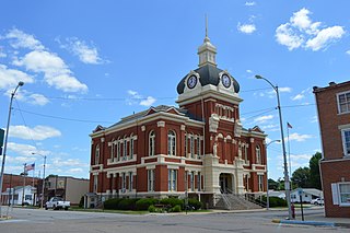
The Winchester Historic District is a historic district which encompasses much of the developed area of Winchester, Illinois. The district includes 438 buildings, of which 273 are contributing buildings. Winchester's historic area represents a typical small, rural county seat; its commercial development is focused around the county courthouse and town square, while low- to moderate-density residential development can be found away from the commercial center. Development in the district began in the 1830s; by the 1870s, most of the significant buildings had been completed. The district's older buildings are mainly designed in the Federal and Greek Revival styles, while its later buildings mostly have Italianate designs. The Greek Revival Presbyterian Church stands out among these traditionally-styled buildings; according to the Illinois Historic Structures Survey, it is the most exceptional Greek Revival church in any Illinois city of over 500 people. The Scott County Courthouse, a late addition to the district in 1885, has also been noted as architecturally significant, though its design does not conform to a single style.

The historic Chicago park and boulevard system is a ring of parks connected by wide, planted-median boulevards that winds through the north, west, and south sides of the City of Chicago. The neighborhoods along this historic stretch include, Logan Square, Humboldt Park, Englewood, Back of the Yards, Lawndale, and Bronzeville. It reaches as far west as Garfield Park and turns south east to Douglas Park. In the south, it reaches Washington Park and Jackson Park, including the Midway Plaisance, used for the 1893 World's Fair.

The Battery Street Historic District encompasses one of the oldest developed areas of Burlington, Vermont. With a history dating to 1790, this area, south of downtown Burlington and initially bounded roughly by Main, St. Paul, and Maple Streets, and Lake Champlain, this area includes a mix of residential, commercial, and industrial uses, with architecture spanning from its early period to the 20th century, including one of the city's oldest houses. The district was listed on the National Register of Historic Places in 1977, and has twice been enlarged, extending west to South Union Street.

The Main Street–College Street Historic District encompasses a historically fashionable residential area of Burlington, Vermont. Principally located along Main and College Streets between South Winooski and South Williams Streets, the area was one of the city's most exclusive residential areas from the early 19th century to the early 20th century, and includes a diversity of high quality architecture from that period. It was listed on the National Register of Historic Places in 1988.


