Lightvessel stations of Great Britain

Last updated

Light vessel 78 Calshot Spit on station in 1979 Calshot Spit lightvessel.jpg
Light vessel 78 Calshot Spit on station in 1979

The history of the many lightvessel stations of Great Britain goes back over 250 years to the placement of the world's first lightship at the Nore in the early 18th century.

Contents

A lightvessel station is a named position at which a lightvessel was placed, rather than a particular ship; individual vessels were often transferred between different stations during their existence. Stations themselves were occasionally changed, especially during wartime, when lights were only displayed in response to specific shipping needs.

History

The world's first lightvessel was the result of a business partnership between Robert Hamblin, a former barber and ship manager from King's Lynn, and David Avery, an investor. [1] In 1730 the pair secured a government licence to moor a ship, with a prominent light affixed to it, to serve as a navigation aid at the Nore in the Thames mouth. Hamblin and Avery intended to profit from the vessel by collecting a fee from passing merchant vessels. The licence was opposed by Trinity House, which considered that it possessed a monopoly on construction and maintenance of navigation aids in British waters. After extensive legal dispute the licence was revoked in 1732 and Trinity House assumed direct responsibility for the proposed lightship; Hamblin and Avery were granted nominal lease revenues in exchange. [2] The Nore lightship commenced operations in 1734. [3]

A second lightvessel was placed at the Dudgeon station, off the Norfolk coast, in 1736, with others following at Owers Bank (1788) and the Goodwin Sands (1793). [3] While the Admiralty opposed the 1802 Sunk lightvessel, claiming it would aid enemy ships, it soon afterwards placed three vessels of its own to protect the fleet during the Napoleonic Wars; they were taken over by Trinity House a few years later. [4] Many others were commissioned during the nineteenth century, especially off England's east coast and the approaches to the Thames, where there were many treacherous shoals.

Lightship LV86, on station at the Nore from 1931 to 1974 Lv-Nore.jpg
Lightship LV86, on station at the Nore from 1931 to 1974

Following their acquisition of the Admiralty ships, all English and Welsh lightvessels were maintained by Trinity House, with the exception of the four vessels in the approaches to the River Mersey, which were maintained by the Mersey Docks and Harbour Board until 1973, and those in the Humber Estuary, which were the responsibility of the Humber Conservancy Board.

Communications and safety

Communication with lightvessels proved to be a major problem for Trinity House; lightvessel crews were well-placed to observe ships in distress, but could not always alert lifeboats on shore. After a series of shipwrecks, an experiment was conducted whereby a nine-mile undersea cable was run from the Sunk lightvessel in the Thames Estuary to the post office at Walton-on-the-Naze. This was intended to commence in 1884, but was plagued by delays; [5] the trial was unsuccessful as the cable repeatedly broke.

As a result of a motion brought forward by Sir Edward Birkbeck, a Royal Commission was established to look at the issue of 'electrical communication' and gave its first Report in 1892; [6] [7] the East Goodwin lightvessel was used during one of Guglielmo Marconi's early experiments in radio transmission in 1896. [8] The world's first radio distress signal was transmitted by the East Goodwin lightvessel's radio operator on 17 March 1899, after the merchant vessel Elbe ran aground on the Goodwins, while on 30 April that year, the East Goodwin vessel transmitted a distress signal on its own behalf, when the SS R. F. Matthews rammed it in a dense fog. Safety was further improved by the development of more powerful lamps and through the replacement by foghorns of the gongs previously used as fog signals.

Crew

Until the second half of the 20th century, all Trinity House vessels were permanently manned. An 1861 article in the Cornhill Magazine described lightshipmen as being paid 55 shillings a month (in addition to drawing 1 shilling and sixpence a week "in lieu of 3 gallons of small-beer"): the vessels were supplied, and the crews relieved, once a month. It was also noted that "a general tone of decent, orderly and superior conduct" was observed, that the men were "very respectable [...] swearing and profane language are [...] prohibited" and that every man was supplied with a Bible as well as "a library of varied and entertaining literature". [9]

By the start of the 20th century, Trinity House lightvessels had a crew of 11, of whom seven (a master and six ratings) would be on active duty at any one time. It was an extremely demanding and dangerous profession, and it would take 15 to 20 years of service to be promoted to master. [10]

Replacement

The majority of British lightvessels were decommissioned during the 1970s - 1980s and replaced with light floats or LANBY buoys, which were vastly cheaper to maintain: in 1974 at the time of Trinity House's original development project, lightship annual running costs at £30,000 were ten times those of the LANBY. [11]

The remaining UK lightvessels have now been converted to unmanned operation and most now use solar power.[ citation needed ]

Vessels

Unlike lightships in the United States and other parts of the world, Trinity House lightvessels were usually unpowered and needed to be towed to or from their position. In order to act as effective daymarks they were painted red, with the station name in large white letters on the side of the hull, and a system of balls and cones at the masthead for identification. The first revolving light was fitted to the Swin Middle lightvessel in 1837: others used occulting or flashing lights. White lights were preferred for visibility though red and very occasionally green (as with the Mouse lightvessel) were also used. [12]

It is likely that photographs on various websites showing named lightvessels, may appear to be structurally different to comparable records on other web pages due to the fact that the particular vessel might have been withdrawn from a station after photographing and being towed away for drydocking, overhaul and possible direction to a new station and therefore a different lightvessel would have been substituted at the named station on withdrawal of the previous lightvessel. This has been most evident on those vessels that have been withdrawn and shipped to another port at home or abroad to become a floating museum, floating restaurant, 'clubhouse', etc. Scarweather LV and Helwick LV have for instance changed their rôle in their lifetime and their appearance on various records varies considerably.

England

Active stations

The following are active stations at which Trinity House still maintains unmanned lightships, which also act as weather stations.

NameImagePositionCharacteristicVessels employed
Foxtrot 3  OOjs UI icon edit-ltr-progressive.svg 51°24′7″N 2°0′28″E [13] Fl W 10sLight vessel no. 93 (from 2001 until 2003), LV17 [14]
East Goodwin  OOjs UI icon edit-ltr-progressive.svg Lightvessel East Goodwin.jpg Goodwin Sands
51°13′18″N 1°36′21″E
Fl W 15s [15] [16] Light vessel no. 93 (from 1947 until 1953), Lightvessel no. 21
Greenwich   OOjs UI icon edit-ltr-progressive.svg Greenwich Light Vessel Automatic, English Channel (geograph 5684240).jpg 50°24′32″N 0°0′6″W Fl W 5s [15] [17] Light vessel no. 5 [18]
Sandettie   OOjs UI icon edit-ltr-progressive.svg Dunkerque Sandettie 2.jpg Sandettie Bank
51°9′21″N 1°47′7″E
Fl W 5s [19] Sandettié (from 1978 until 1989)
Sevenstones   OOjs UI icon edit-ltr-progressive.svg Sevenstones Light Vessel (5954213760).jpg 50°3′37″N 6°4′20″W Fl(3) W 30s [15] [20] Sevenstones Lightship (1841) (from 1841 until 1879), Tyne III (from Sep 1879 until 1883), T.S. Orwell (from 1947 until 1958)
Sunk Inner  OOjs UI icon edit-ltr-progressive.svg 51°51′7″N 1°34′23″E [21] Fl(5) 15s
Varne  OOjs UI icon edit-ltr-progressive.svg Varne Lightvessel.jpg Varne Bank
51°1′15″N 1°23′53″E [22]
Fl R 5s [15] Varne, Lightvessel no. 21 (from 1980)

Former stations

NamePositionOperatorSeaVessels employedNotes
Mersey Bar  OOjs UI icon edit-ltr-progressive.svg 53°32′1″N 3°20′59″W [23] Mersey Docks and Harbour Company River Mersey Alarm [24] (from 1913 until 1960), Planet [25] (from 1960 until 1972)
Bar Flat  OOjs UI icon edit-ltr-progressive.svg Wisbech Bar The Wash Established 1878; [26] later replaced by Roaring Middle LV
Barrow Deep  OOjs UI icon edit-ltr-progressive.svg Barrow Deep Thames Estuary
Black Deep  OOjs UI icon edit-ltr-progressive.svg Black Deep Thames Estuary Station established 1889 [27]
Brake  OOjs UI icon edit-ltr-progressive.svg Brake Bank Gull Stream [28] (from 1930 until 1940)Station established 1930, replacing Gull LV station, due to narrowing of the navigable Gull Stream [29]
Bull  OOjs UI icon edit-ltr-progressive.svg Bull SandHumber Conservancy Board Humber Spurn [30] (from 1959)
Calshot Spit  OOjs UI icon edit-ltr-progressive.svg Calshot Spit Southampton Water Lightvessel no. 78 [31] (from 1914), Tyne III (from 1943 until 1951), Light vessel no. 16 [32]
Channel   OOjs UI icon edit-ltr-progressive.svg 49°55′0″N 2°54′0″W English Channel Planet, Light vessel no. 3 [33]
Cockle  OOjs UI icon edit-ltr-progressive.svg Great Yarmouth North Sea T.S. Lord Nelson [34] (from 1936)
Cork  OOjs UI icon edit-ltr-progressive.svg Cork Ledge
51°56′42″N 1°26′6″E
North Sea LV86, T.S. Lord Nelson [35]
Corton  OOjs UI icon edit-ltr-progressive.svg Lowestoft North Sea
Cromer Knoll  OOjs UI icon edit-ltr-progressive.svg 53°16′0″N 1°18′0″E North Sea
Crosby  OOjs UI icon edit-ltr-progressive.svg Crosby Channel Mersey Docks and Harbour Company Liverpool Bay
Inner Dowsing  OOjs UI icon edit-ltr-progressive.svg Inner Dowsing North Sea Light vessel no. 16 [32] , Light vessel no. 95 [36] , Light vessel no. 93 [37] (1998)The last manned lightship station, replaced by the Dowsing lighthouse in 1991. [38]
Outer Dowsing  OOjs UI icon edit-ltr-progressive.svg Outer Dowsing North Sea Outer Dowsing [39]
Dudgeon  OOjs UI icon edit-ltr-progressive.svg Dudgeon Shoals
53°15′30″N 1°13′30″E [40]
North Sea Dudgeon was the second lightvessel to be established, with a patent granted to David Avery in 1736. [41] LV63 was on station when bombed by the Luftwaffe on 29 January 1940. Only one crew member, John Sanders, survived. The incident was the subject of a 1940 British Government propaganda film, Men of the Lightship . [42]
Edinburgh Channel  OOjs UI icon edit-ltr-progressive.svg Edinburgh Channels Thames Estuary LV86 [35] Station established 1889 replacing the S.W. Longsand buoy [27]
English and Welsh Grounds  OOjs UI icon edit-ltr-progressive.svg Bristol Channel Light Vessel 72, John Sebastian
Falls  OOjs UI icon edit-ltr-progressive.svg 51°18′6″N 1°48′30″E [40] Strait of Dover
North Folkestone Gate  OOjs UI icon edit-ltr-progressive.svg Strait of Dover Part of wartime Folkestone Gate Channel defences; discontinued 1919 [43]
South Folkestone Gate  OOjs UI icon edit-ltr-progressive.svg Strait of Dover Light vessel no. 75 [44] Part of wartime Folkestone Gate Channel defences. LV75 attacked on station and sunk by German bombers in July 1940, with the loss of two crew members, Jack Wade and Harry North [45]
Formby  OOjs UI icon edit-ltr-progressive.svg Formby Beach Mersey Docks and Harbour Company Liverpool Bay
Galloper  OOjs UI icon edit-ltr-progressive.svg The Galloper North Sea Tyne III [46] (1929), Light vessel no. 93 [37] (from 1954 until 1974)Station first established by the Admiralty in 1803 to protect the fleet during the Napoleonic Wars; [4] replaced by buoy 1977 [47]
Girdler  OOjs UI icon edit-ltr-progressive.svg Girdler Shoal Thames Estuary In 1884 the Girdler lightship was rammed and sunk by Indus; there were no deaths. [48]
Gull  OOjs UI icon edit-ltr-progressive.svg Goodwin Sands Admiralty, Trinity House North Sea Gull Stream (from 1929 until 1930)Marked the Gull Stream: station first established by the Admiralty in 1809 and taken over by Trinity House in 1826. [49] Narrowing of the channel led to Gull being replaced by Brake LV in 1930 [29]
Gunfleet  OOjs UI icon edit-ltr-progressive.svg Gunfleet Sands Trinity House Thames Estuary Replaced by Gunfleet Lighthouse in 1850.
Haisborough  OOjs UI icon edit-ltr-progressive.svg Haisborough Sands North Sea Light vessel no. 3 [50] , Lightvessel no. 68 [51]
Humber  OOjs UI icon edit-ltr-progressive.svg Humber Conservancy Board Humber Helwick [52] (from 1937 until 1942)Maintained by Humber Conservancy Board.
Kentish Knock  OOjs UI icon edit-ltr-progressive.svg Kentish Knock North Sea Light vessel no. 3 [33] , Lightship 2000, Jenni Baynton [53] (from 1949 until 1953)
Smiths Knoll  OOjs UI icon edit-ltr-progressive.svg Smiths Knoll
52°43′30″N 2°18′0″E [40]
Trinity House North Sea
Leman and Ower  OOjs UI icon edit-ltr-progressive.svg Trinity House North Sea
Longsand  OOjs UI icon edit-ltr-progressive.svg 51°47′40″N 1°40′0″E [54] Trinity House Thames Estuary
Lune Deep  OOjs UI icon edit-ltr-progressive.svg 53°56′48″N 3°7′56″W Trinity House Morecambe Bay Unattended gas lit "lightboat", established 1909
Mid Barrow  OOjs UI icon edit-ltr-progressive.svg Barrow Deep Trinity House Thames Estuary In the middle of fairway of Barrow Deep, 9m SW of Barrow Deep LV [55]
Morecambe Bay  OOjs UI icon edit-ltr-progressive.svg 53°54′0″N 3°31′0″W Trinity House Morecambe Bay Breeveertien, LV94 [56] , Light vessel no. 70 [57] (1903)
Mouse  OOjs UI icon edit-ltr-progressive.svg Mouse Sand Trinity House Thames Estuary Gull Stream
Nab  OOjs UI icon edit-ltr-progressive.svg Nab Rock Trinity House The Solent Replaced by the Nab Tower in 1920.
Newarp  OOjs UI icon edit-ltr-progressive.svg Newarp Banks Trinity House North Sea Light vessel no. 44, Lightvessel no. 21 [58] (1972), LV83 [59] (1967)
Nore  OOjs UI icon edit-ltr-progressive.svg Nore Trinity House Thames Estuary LV86 [60] (from 1941 until 1942)The world's first manned lightship, 1731.
North Goodwin  OOjs UI icon edit-ltr-progressive.svg Goodwin Sands Trinity House North Sea
North West  OOjs UI icon edit-ltr-progressive.svg Mersey Docks and Harbour Company River Mersey Good Intent [61] (from 1813)
Outer Gabbard  OOjs UI icon edit-ltr-progressive.svg Outer Gabbard
51°59′23″N 2°4′38″E [40]
Trinity House North Sea Light vessel no. 3 [33] , Jenni Baynton [53] (from 1962 until 1965), Tyne III [62] (1911)
Owers  OOjs UI icon edit-ltr-progressive.svg The Owers, off Selsey Bill Trinity House English Channel Light vessel no. 3Replaced with a beacon. LV Owers now a wreck in Tel Aviv harbour.[ citation needed ]
Roaring Middle  OOjs UI icon edit-ltr-progressive.svg 52°58′38″N 0°21′5″E The Wash Replaced Bar Flat LV; replaced with buoy 1919 [63]
Royal Sovereign  OOjs UI icon edit-ltr-progressive.svg Royal Sovereign Shoals Trinity House English Channel Lightship 2000 [64] Replaced with Royal Sovereign lighthouse 1971.
Selker  OOjs UI icon edit-ltr-progressive.svg Selker Rocks
54°16′5″N 3°30′15″W [65]
Trinity House Irish Sea
Shambles  OOjs UI icon edit-ltr-progressive.svg The Shambles
50°36′50″N 2°20′30″W
Trinity House English Channel Tyne III [46] (from 1891 until 1909), Trinity, Light vessel no. 67
Shipwash  OOjs UI icon edit-ltr-progressive.svg Shipwash Shoal
52°2′0″N 1°42′0″E [40]
North Sea Light Vessel 72 [66] , Mary Mouse 2 [67] (from 1968 until 1969), LV94
South Goodwin  OOjs UI icon edit-ltr-progressive.svg Goodwin Sands Trinity House North Sea Light vessel no. 69 [68] (until 1940), Light vessel no. 90 (until 1954), LV17Replaced South Foreland Low lighthouse. LV69 was sunk on station, probably by a mine, in October 1940. [69] The replacement, LV90, sank on 27 November 1954 when cables to her two sea anchors broke in a hurricane-force storm. The ship ran onto the Goodwin Sands close to the Keller Gut and turned on her side. The seven crew members perished, the only survivor being Ronald Murton, an ornithologist from the Ministry of Agriculture and Fisheries. The wreck of the ship can still be seen at low tide. The next replacement ship was decommissioned and was towed away on 26 July 2006. [70] [71] [72]
Spurn  OOjs UI icon edit-ltr-progressive.svg Spurn Point Humber Conservancy Board Humber Spurn [73] (from 1927), Sula [74] (from 1959)
Sunk  OOjs UI icon edit-ltr-progressive.svg Sunk Sands
51°49′35″N 1°30′40″E
Thames Estuary Established 1802; replaced 2007 by Sunk Centre as part of a new Traffic Separation Scheme (TSS).
Sunk Centre  OOjs UI icon edit-ltr-progressive.svg 51°50′3″N 1°46′2″E [75] Established as part of TSS in 2007. Decommissioned 2021.
Swarte Bank  OOjs UI icon edit-ltr-progressive.svg North Sea Established 6 December 1912 [76]
Swin Middle  OOjs UI icon edit-ltr-progressive.svg Swin Trinity House Thames Estuary The first revolving light was fitted to the Swin Middle lightvessel in 1837.[ citation needed ]
Tongue  OOjs UI icon edit-ltr-progressive.svg Tongue Sands
51°30′39″N 1°23′5″E [40]
North Sea Jenni Baynton, Light vessel no. 5 (1973)
Lynn Well  OOjs UI icon edit-ltr-progressive.svg Trinity House The Wash Gull Stream [77] , Light Vessel no. 89 [78] Replaced with a Lanbyin September 1973.
Would  OOjs UI icon edit-ltr-progressive.svg Haisborough Sands North Sea

Scotland, Isle of Man

Lightvessels in Scotland and the Isle of Man were maintained by the Northern Lighthouse Board, with the exception of those maintained by the Clyde Lighthouse Trust and by the Dundee Port Trustees. Of the NLB vessels, only the North Carr was crewed.

NamePositionOperatorSeaVessels employedNotes
Abertay  OOjs UI icon edit-ltr-progressive.svg Gaa Sand
56°27′0″N 2°42′0″W
Trustees of the Harbour of Dundee Firth of Tay Established 1877. First lightship in Europe to be fully automated, 1971; discontinued 1984. [79]
Bahama Bank   OOjs UI icon edit-ltr-progressive.svg Bahama Bank
54°19′40″N 4°12′55″W
Northern Lighthouse Board Ramsey Bay Bahama Bank (from 1848), Bahama Bank [80] (from Sep 1879)Replaced by Maughold Head Lighthouse in 1914.
Cath Sgeir  OOjs UI icon edit-ltr-progressive.svg Isle of Gigha Northern Lighthouse Board Sound of Jura Uncrewed "lightboat". Established 2 June 1905 [81]
Clyde  OOjs UI icon edit-ltr-progressive.svg Kilbrannan Sound
55°10′0″N 5°22′0″W
Northern Lighthouse Board Firth of Clyde North Carr Wartime station; established c. 1944 [82]
Garmoyle  OOjs UI icon edit-ltr-progressive.svg Port Glasgow Clyde Lighthouse Trustees River Clyde Established 1868. Replaced by buoy in 1905 [83]
Garvel  OOjs UI icon edit-ltr-progressive.svg Clyde Lighthouse Trustees River Clyde GarvelOriginal crewed lightship replaced 1882 by unattended, gas lit vessel built by Blackwood & Gordon. [84] Removed 1915
North Carr  OOjs UI icon edit-ltr-progressive.svg North Carr Northern Lighthouse Board Firth of Forth North Carr (from 1887 until 1889), North Carr (from 1889 until 1933), North Carr (from 1933 until 1975)
Skeirinoe  OOjs UI icon edit-ltr-progressive.svg The Minch Northern Lighthouse Board Sea of the Hebrides Uncrewed "lightboat" stationed near Scalpay; [85] established 1906.
Otter Rock  OOjs UI icon edit-ltr-progressive.svg Otter Rock
55°34′0″N 6°8′0″W
North Channel Scottish Maritime Museum in Irving has a small scale coloured General Arrangement (1923) from Builder (Clyde Shipbuilding and Engineering Co. Ltd. hull #249, 60 ft [183 m]).

Wales

Breaksea Light Vessel following a refit at Swansea in 1978. Former Breaksea lightvessel.jpg
Breaksea Light Vessel following a refit at Swansea in 1978.
Scarweather Bateau feu Scarweather.jpg
Scarweather

Former Welsh lightships were maintained by Trinity House. Remaining substitute navigational aids still are.

NamePositionOperatorSeaVessels employedNotes
Breaksea  OOjs UI icon edit-ltr-progressive.svg 51°19′9″N 3°19′0″W Trinity House Bristol Channel Trinity [86] Replaced by a LANBY, then a lightfloat and currently a lighted buoy with RACON radar facility


See also

Related Research Articles

<span class="mw-page-title-main">Trinity House</span> Official authority for lighthouses in England

The Corporation of Trinity House of Deptford Strond, also known as Trinity House, is the official authority for lighthouses in England, Wales, the Channel Islands and Gibraltar. Trinity House is also responsible for the provision and maintenance of other navigational aids, such as lightvessels, buoys, and maritime radio/satellite communication systems. It is also an official deep sea pilotage authority, providing expert navigators for ships trading in Northern European waters.

<span class="mw-page-title-main">Lightvessel</span> Ship that acts as a lighthouse

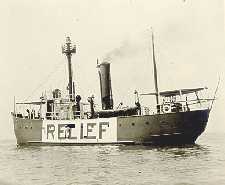
A lightvessel, or lightship, is a ship that acts as a lighthouse. They are used in waters that are too deep or otherwise unsuitable for lighthouse construction. Although some records exist of fire beacons being placed on ships in Roman times, the first modern lightvessel was off the Nore sandbank at the mouth of the River Thames in London, England, placed there by its inventor Robert Hamblin in 1734. The type has become largely obsolete; lighthouses replaced some stations as the construction techniques for lighthouses advanced, while large, automated buoys replaced others.

Lightvessels in Ireland describes any lightvessel or light float previously stationed off the coast of Ireland. The Commissioners of Irish Lights are responsible for the majority of marine navigation aids around the whole of the island of Ireland.

<span class="mw-page-title-main">Goodwin Sands</span> Sandbank off the east coast of England

<span class="mw-page-title-main">Thames Estuary</span> Estuary in which the River Thames meets the waters of the North Sea

The Thames Estuary is where the River Thames meets the waters of the North Sea, in the south-east of Great Britain.

<span class="mw-page-title-main">Nore</span> Sandbank at the mouth of the Thames Estuary

The Nore is a long bank of sand and silt running along the south-centre of the final narrowing of the Thames Estuary, England. Its south-west is the very narrow Nore Sand. Just short of the Nore's easternmost point where it fades into the channels it has a notable point once marked by a lightship on the line where the estuary of the Thames nominally becomes the North Sea. A lit buoy today stands on this often map-marked divisor: between Havengore Creek in east Essex and Warden Point on the Isle of Sheppey in Kent.
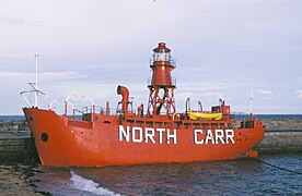
United States lightship <i>Huron</i> (LV-103) 1920 lightvessel, now a museum ship in Port Huron, Michigan, United States

The United States lightship Huron (LV-103) is a lightvessel that was launched in 1920. She is now a museum ship moored in Pine Grove Park, Port Huron, St. Clair County, Michigan.

Sevenstones Lightship

Sevenstones Lightship is a lightvessel station off the Seven Stones Reef which is nearly 15 miles (24 km) to the west-north-west (WNW) of Land's End, Cornwall, and 7 miles (11 km) east-north-east (ENE) of the Isles of Scilly. The reef has been a navigational hazard to shipping for centuries with seventy-one named wrecks and an estimated two hundred shipwrecks overall, the most infamous being the oil tanker Torrey Canyon on 18 March 1967. The rocks are only exposed at half tide. Since it was not feasible to build a lighthouse, a lightvessel was provided by Trinity House. The first was moored near the reef on 20 August 1841 and exhibited its first light on 1 September 1841. She is permanently anchored in 40 fathoms (73 m) and is 2.5 miles (4.0 km) north-east (NE) of the reef. Since 1987, the Sevenstones Lightship has been automated and unmanned.

Sandettie Lightvessel

Sandettie is a lightvessel station located at Sandettie Bank in the North Sea. It is one of the 22 coastal weather stations whose conditions are reported in the BBC Shipping Forecast. The vessel is named after her location on the Sandettie Bank, due north of Calais and due east of the South Foreland. The ship has no engine and is not crewed. Its lights are powered by solar panels.

Channel Lightvessel

Channel was the name of a lightvessel station located in the English Channel between 1979 and August 2021, when it was replaced with a light buoy. It was also one of the 22 coastal weather stations whose conditions were reported in the BBC Shipping Forecast. The vessel's position was 49°55′N2°54′W, approximately 56 km (35 mi) north-northwest of Guernsey.

United States lightship <i>Frying Pan</i> (LV-115)

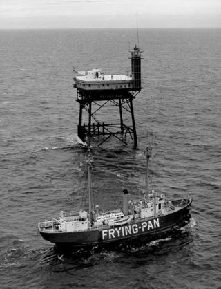
Frying Pan (LV-115) is a lightvessel moored at Pier 66a in the Chelsea neighborhood of Manhattan in New York City. It served at Frying Pan Shoals, off Cape Fear in North Carolina, for over 30 years.

<span class="mw-page-title-main">Lansing Shoals Light Station</span> Lighthouse in Michigan, United States

The Lansing Shoals Light Station is a lighthouse located in northeastern Lake Michigan, 6.3 miles (10.1 km) southeast of Point Patterson, in Newton Township, Mackinac County, Michigan. It was listed on the National Register of Historic Places in 2005.

The Kentish Knock is a long shoal in the North Sea east of Essex, England. It is the most easterly of those of the Thames Estuary and its core, which is shallower than 18 feet (5.5 m), extends 6 miles (9.7 km). Thus it is a major hazard to deep-draught navigation. It is exactly 28 miles (45 km) due east of Foulness Point, Essex and is centred about 15 miles (24 km) NNE of North Foreland, Kent – both are extreme points of those counties.

Five Fathom Bank light station was a station for lightvessels in New Jersey, United States. It was located off the south end of Five Fathom Bank, 14.7 miles and 100 degrees from the Cape May Lighthouse. The station was in service from 1837 to 1972 before ultimately being replaced by a horn buoy.

Bahama Bank Lightship

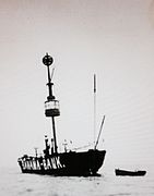
The Bahama Bank Lightship was a Lightvessel stationed on the Bahama Bank east of Ramsey Bay, Isle of Man.

<span class="mw-page-title-main">LV 78 Calshot Spit</span>

LV 78Calshot Spit is a former Trinity House lightvessel that was anchored off Calshot Spit and is now a museum ship in Southampton.

The Inner and Outer Dowsing sand banks are shallow-water shoals off the Lincolnshire coast of the UK sector of southern North Sea. They have been used for navigation, as a commercial fishery, for aggregate dredging, and more recently as the location for major offshore wind farms.

References

  1. Naish, J. M. Seamarks: Their History and Development, Stanford Maritime, 1985, ISBN   978-0-540-07309-2, p. 107
  2. The Nautical Magazine and Naval Chronicle for 1865. Cambridge University Press. 2013. p. 624. ISBN   9781108054911.
  3. 1 2 Marcus, G.J. (1975). Heart of Oak: A Survey of British Sea Power in the Georgian Era . Oxford University Press. pp.  53–54. ISBN   0192158120.
  4. 1 2 Renton (2001) Lost Sounds: the story of coast fog signals, Dundurn, p.148
  5. BOARD OF TRADE — TELEGRAPHIC COMMUNICATION WITH LIGHT VESSELS, Hansard 16-05-1884
  6. COAST COMMUNICATIONS, Hansard 26-04-1892
  7. COMMUNICATION WITH LIGHTHOUSES, Hansard 21-03-1893
  8. Baker, W. J. (1998). History of the Marconi Company. Routledge. pp. 39–40. ISBN   978-0-415-14624-1.
  9. Light-Vessels , The Cornhill Magazine, III (1861), 39.
  10. Trinity House, portcities.org, accessed 02-09-08
  11. Rowlands, D. "Points of Reference", Design 310 (1974)
  12. Miltoun, F. (ed) Ships and Shipping , Moring Ltd, 1903, Ch. 11
  13. https://www.marinetraffic.com/en/ais/details/ships/shipid:849825/mmsi:992351033/imo:0/vessel:FOXTROT_3_LV
  14. https://www.ibiblio.org/lighthouse/lightships.htm
  15. 1 2 3 4 NGA List of Lights, Radio Aids and Fog Signals, National Geospatial-Intelligence Agency, Wikidata   Q13872896
  16. https://www.trinityhouse.co.uk/lighthouses-and-lightvessels/east-goodwin-lightvessel
  17. https://www.trinityhouse.co.uk/lighthouses-and-lightvessels/greenwich-lightvessel
  18. https://web.archive.org/web/20150924012054/http://www.feuerschiffseite.de/SCHIFFE/ENGLAND/lv05/lv5gb.htm
  19. Reeds PBO Small Craft Almanac 2014. ISBN   978-1-4081-9330-3. OL   32692860M. Wikidata   Q25198336.
  20. https://www.trinityhouse.co.uk/lighthouses-and-lightvessels/sevenstones-lightvessel
  21. https://www.marinetraffic.com/en/ais/details/ships/shipid:849819/mmsi:992351027/imo:0/vessel:SUNK_INNER
  22. MarineTraffic, Wikidata   Q18518862
  23. https://www.trinityhouse.co.uk/notice-to-mariners/13-15-bar-lighted-buoy-and-float
  24. https://confidentials.com/liverpool/birth-of-a-new-planet
  25. https://www.nationalhistoricships.org.uk/register/1572/light-vessel-23-mersey-bar
  26. "Nautical Notices", Nautical Magazine, v. XLVII (New Series), No XI (Nov 1878), 1031
  27. 1 2 "Notice to Mariners", Board of Trade Journal, v7 (1889), 617-618
  28. https://www.thurrock.gov.uk/history-on-river-thames/gull-lightvessel-38
  29. 1 2 The Gull', lightvessel 38, Thurrock Council, accessed 02-12-21
  30. http://museumcollections.hullcc.gov.uk/collections/storydetail.php?irn=7&master=10
  31. https://www.nationalhistoricships.org.uk/register/144/light-vessel-78-calshotspit
  32. 1 2 https://www.nationalhistoricships.org.uk/register/131/light-vessel-16-inner-dowsing
  33. 1 2 3 https://web.archive.org/web/20160327090123/http://broadcasting-fleet.com/kingdavid2.htm
  34. https://www.nationalhistoricships.org.uk/register/645/light-vessel-88
  35. 1 2 https://www.ibiblio.org/lighthouse/engse.htm
  36. https://www.trinitybuoywharf.com/architecture/lightship-lv95
  37. 1 2 https://www.nationalhistoricships.org.uk/register/2872/light-vessel-93
  38. Trinity House, portcities.org
  39. http://www.tynebuiltships.co.uk/O-Ships/outerdowsing1925.html
  40. 1 2 3 4 5 6 Radio Navigational Aids , Naval Oceanographic Office, 1973, Wikidata   Q7280925
  41. Naish, J. (1985) Seamarks: their history and development, Stanford, p.108
  42. David MacDonald (Director); Alberto Cavalcanti (Producer) (1940). Men of the Lightship (Film (35mm, 24 mins, black & white)). GPO Film Unit.
  43. US Navy Hydrographic Office (1919) Index to Notices to Mariners, 1-52, p.177
  44. https://www.wrecksite.eu/wreck.aspx?73273
  45. Carter, G (1974) The Battle of Britain: the Home Front, Mason & Lipscomb, pp.190-1
  46. 1 2 https://friendsoflv50.org.uk/history/
  47. Defense Mapping Agency (1977), Notices to Mariners, p.5
  48. "Girdler Lightship loss". The Wrecksite.
  49. Stevenson (2013) The World's Lighthouses: From Ancient Times to 1820, Courier, p.124
  50. https://www.lightphotos.net/photos/displayimage.php?pos=-1844
  51. https://www.liverpoolmuseums.org.uk/artifact/photograph-of-haisbro-lightship-68-0
  52. https://www.nationalhistoricships.org.uk/register/137/light-vessel-91-humber
  53. 1 2 http://offshoreradiomuseum.co.uk/page832.html
  54. The London Gazette 25290 (PDF), The London Gazette, Wikidata   Q109152990
  55. Imray and Kettle (1917) Pilot's Guide for the River Thames: The South-east Coast of England, and the Strait of Dover, Imray, Laurie, Norie & Wilson, p.24
  56. https://www.nationalhistoricships.org.uk/register/646/light-vessel-94-morecambe-bay
  57. https://www.google.co.uk/books/edition/Light_in_the_Darkness/ShmtCwAAQBAJ
  58. https://lv21.co.uk/history-of-lv21/crew-stories/
  59. https://www.liverpoolmuseums.org.uk/artifact/photograph-of-newarp-lightship-83
  60. https://www.nationalhistoricships.org.uk/register/488/light-vessel-86-nore
  61. https://www.hslc.org.uk/wp-content/uploads/2017/06/97-9-Woods.pdf
  62. https://friendsoflv50.org.uk/john-conway-master-of-outer-gabbard-light-vessel-lv50-1911/
  63. Admiralty, Notices to Mariners 348, 1919
  64. https://www.eastbourneherald.co.uk/news/traffic-and-travel/nostalgia-royal-sovereign-lightship-eastbourne-coast-957200
  65. The London Gazette 25254 (PDF), The London Gazette, Wikidata   Q109152953
  66. https://lighthouseaccommodation.co.uk/directory/lv72-juno-lightvessel/
  67. http://www.gosportheritage.co.uk/wordpress/wp-content/uploads/2018/02/lightship-brochure-1-Read-Only.pdf
  68. https://goodwinsands.org.uk/the-disappearing-lightship/
  69. The Disappearing Lightship, Goodwin Sands Conservation Trust, accessed 20-12-21
  70. South Goodwin Light Vessel, portcities.org
  71. "South Goodwin Lightvessel Trinity House History". trinityhousehistory.wordpress.com. 27 November 2014. Retrieved 27 July 2017.
  72. Historic England. "ST MARGARET'S OLD LIGHTHOUSE, St. Margaret's At Cliffe (1070066)". National Heritage List for England . Retrieved 27 July 2017.
  73. https://www.nationalhistoricships.org.uk/register/671/light-vessel-12-spurn
  74. https://www.nationalhistoricships.org.uk/register/2447/light-vessel-14-sula
  75. https://www.marinetraffic.com/en/ais/details/ships/shipid:849826/mmsi:992351034/imo:0/vessel:SUNK_CENTR
  76. The Nautical Magazine, v88 (1912), 360
  77. https://www.nationalhistoricships.org.uk/register/139/light-vessel-38-gull
  78. https://www.nationalhistoricships.org.uk/register/647/light-vessel-89-wash
  79. Abertay Lightship, Dundee Maritime, accessed 22-12-21
  80. http://www.lightkeepersjourney.com/bahama.html
  81. US Navy Hydrographic Office, (1906) Notices to Mariners, nos 1-52, p.355
  82. US Navy Hydrographic Office (1944), Supplement to British Islands Pilot: the western coast of Scotland from Mull of Galloway to Rudh' Re and off-lying islands, Volume 4, p.2
  83. Riddell, J.F.(1979) Clyde Navigation: A History of the Development and Deepening of the Clyde, John Donald, p.98
  84. "Launches - Scotch". The Marine Engineer, Feb 1, 1882, 254
  85. Map of Skeirinoe lightvessel (via National Library of Scotland maps API (Map) (Popular Edition (Scotland) ed.). 1:253 440. Ordnance Survey. 1920–1930. Retrieved 13 August 2011.
  86. https://lighthouseaccommodation.co.uk/directory/lv15-trinity-lightvessel/

Commons-logo.svg Media related to Lightships of the United Kingdom at Wikimedia Commons