Lindhurst

Last updated

Lindhurst
Civil parish
Wind Farm, Off Blidworth Lane, Rainworth, Notts. (geograph 3737446).jpg
Lindhurst Wind Farm
Lindhurst
Parish map
Nottinghamshire UK location map.svg
Red pog.svg
Lindhurst
Location within Nottinghamshire
Area1.40 sq mi (3.6 km2)
Population14 (2021) [1]
  Density 10/sq mi (3.9/km2)
OS grid reference SK 564578
  London 120 mi (190 km)  SE
District
Shire county
Region
Country England
Sovereign state United Kingdom
Post town MANSFIELD
Postcode district NG18
Dialling code 01623
Police Nottinghamshire
Fire Nottinghamshire
Ambulance East Midlands
UK Parliament
List of places
UK
England
Nottinghamshire
53°06′50″N1°09′25″W / 53.114°N 1.157°W / 53.114; -1.157

Lindhurst is a civil parish and hamlet in the Newark and Sherwood district, is 120 miles (190 km) north west of London, 11 miles (18 km) north of Nottingham the county town, and 3 miles (4.8 km) south east of Mansfield, the nearest market town and bordering its district border. It sits within western Nottinghamshire county, England.

Contents

At the time of the 2011 census the population was less than 100 people and so actual numbers were not given, [2] instead combined with neighbouring Rainworth for a total of 6,315 residents. [3] In 2021 however, the population was given as 14 residents. [1]

Plaque on Forest Stone, Black Scotch Lane Plaque on Forest Stone (geograph 2761151).jpg
Plaque on Forest Stone, Black Scotch Lane

Geography

Lindhurst parish is predominantly rural and roughly diamond shaped. The only paved route is the country lane Blidworth Road bypassing Rainworth in the east of the parish. The hamlet and other features are accessed via paths, tracks and bridleways.

The western end contains a portion of Harlow Wood, while the centre holds a small cluster of farmhouses, agricultural facilities along with a livery yard business and has the highest point in the parish at 155 metres (509 ft). It is bounded to the south with the Rainworth Water stream which flows into several ponds and lakes, and at the north by the Foulevil Brook, both of which flow into the 'L Lake' at the eastern corner, so named due to its shape.

Lindhurst abuts to its western edge the Harlow Wood village community in Ashfield, a small boundary of the Ravenshead parish in Gedling borough to the south, Blidworth is also south and Rainworth to the east. The Forest Stone, a listed monument along the north boundary, commemorates a medieval forest court. [4]

Lindhurst Wind Farm has 5 turbines providing up to 9MW of power, and at 125 metres (410 ft) in height is visible for several miles around. [5] [6] One of the turbines, as well as the lower half of the parish lay within the Nottingham green belt boundary. [7]

History

Toponymy

The area was known originally as Lyndhurst Wood. [8] The name meant ‘lime-tree hill’ suggesting lime trees were dominant in the area. [9]

Heritage

Lyndhurst Wood, as the area was known originally had the status of the ‘chief wood of Sherwood' and anciently was part of Harlow Wood. [8] Although lime trees were originally dominant in this area, [9] by medieval times it mainly held oak trees, and these were used to repair Nottingham Castle between 1358 and 1368. [10] The area also has a link to the Robin Hood legend, the site of an ancient moat across from Fountain Dale is alternatively called 'Friar Tuck Island' and is supposed to be where the two met and the friar was challenged to carry the outlaw over, but with Tuck eventually throwing him in. [11] The moat was also the site of a toll house and medieval hunting lodge, and presently is listed as a scheduled monument. [12]

Lindhurst was owned by The Crown, but in the 18th century, the area was claimed by the Duke of Portland as part of his existing holdings, the land was enclosed and a new hunting lodge was built c.1760. [13] When the disputed area was followed up by government commissioners appointed to look at land ownership, the Duke maintained his right to the area, and this appears to not have been thoroughly investigated and possibly forgotten, [11] or that a little documented sale agreement was eventually made. [14] Later on, it was cleared and turned into farmland with the Rainworth Water dammed and the resulting ponds used as irrigation. The lodge was repurposed into Lyndhurst Farm, which is how it remains to this day. [8]

Related Research Articles

<span class="mw-page-title-main">Newark and Sherwood</span> Non-metropolitan local government district in Nottinghamshire, England

Newark and Sherwood is a local government district in Nottinghamshire, England. It is the largest district by area in the county. The council is based in Newark-on-Trent, the area's largest town. The district also includes the towns of Southwell and Ollerton along with a large rural area containing many villages. Much of the district lies within the ancient Sherwood Forest and there are also extensive forestry plantations in the area.

<span class="mw-page-title-main">Blidworth</span> Human settlement in England

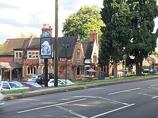
Blidworth is a village and civil parish approximately five miles east of Mansfield, Nottinghamshire, England. The population of the civil parish at the 2011 census was 4,457. Its history can be traced back to the 10th century, although many of the current houses were built in the first half of the 20th century to provide housing for workers at Blidworth Colliery (1926–1989). These are mainly in estates north of Dale Lane, known as New Blidworth. The area around Main Street, west of Beck Lane and including the church, is Old Blidworth, containing some of the oldest buildings. Blidworth Bottoms is a hamlet about 0.5 km south of Old Blidworth.

<span class="mw-page-title-main">Sherwood (UK Parliament constituency)</span> Parliamentary constituency in the United Kingdom, 1983 onwards

Sherwood is a constituency represented in the House of Commons of the UK Parliament since 2010 by Mark Spencer, a Conservative. The constituency takes its name from the Sherwood Forest which is in the area.

<span class="mw-page-title-main">Mansfield (UK Parliament constituency)</span> Parliamentary constituency in the United Kingdom, 1885 onwards

Mansfield is a constituency created in 1885 represented in the House of Commons of the UK Parliament since 2017 by Ben Bradley of the Conservative Party, who gained the seat at the 2017 general election, from the Labour Party. This is the first time the seat has been represented by a Conservative since its creation in 1885.

<span class="mw-page-title-main">Ravenshead</span> Human settlement in England

Ravenshead is a large village and civil parish in the Gedling district of Nottinghamshire, England. It borders Papplewick, Newstead Abbey and Blidworth, and is part of Nottinghamshire's Hidden Valleys area. According to the 2001 census it had a population of 5,636, reducing marginally to 5,629 at the 2011 census.

Newark and Sherwood District Council elections are held every four years. Newark and Sherwood District Council is the local authority for the non-metropolitan district of Newark and Sherwood in Nottinghamshire, England. Since the last boundary changes in 2015, 39 councillors have been elected from 21 wards.

<span class="mw-page-title-main">Rainworth</span> Village in Nottinghamshire, England

Rainworth is a village in the ceremonial county of Nottinghamshire in the East Midlands of England. It is split between the local government districts of Newark and Sherwood and Mansfield.

Lindhurst Wind Farm is a power-producing wind farm in Lindhurst parish near Mansfield, England. Built for Npower Renewables, it produces electricity from five wind turbines. It has a total nameplate capacity of 9 MW of electricity, providing enough power to serve the average needs of 5,400 homes.

<span class="mw-page-title-main">Blidworth and Rainworth railway station</span> Former railway station in Nottinghamshire, England

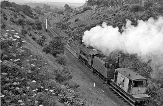
Blidworth and Rainworth railway station was a railway station which served the villages of Blidworth and Rainworth, Nottinghamshire, England.

<span class="mw-page-title-main">St Albans, Nottinghamshire</span> Civil parish in England

St. Albans is a civil parish in the Gedling borough of Nottinghamshire, England.

<span class="mw-page-title-main">Flawborough</span> Civil parish in England

Flawborough is a small hamlet and civil parish in the Rushcliffe borough of Nottinghamshire, England.

<span class="mw-page-title-main">Staunton, Nottinghamshire</span> Village in East Midlands, England

Staunton is a small village and civil parish in the Newark and Sherwood district of Nottinghamshire, England. It takes its name from the Vale of Belvoir and shares it with the local Staunton family, which has resided in the area since the Norman Conquest and possibly before, making them one of the English families living longest on its own estate.

<span class="mw-page-title-main">Moorhouse, Nottinghamshire</span> Human settlement in England

Moorhouse or Laxton Moorhouse is a hamlet within the Laxton and Moorhouse parish, in the Newark and Sherwood district of central Nottinghamshire, England.

<span class="mw-page-title-main">Kersall</span> Human settlement in England

Kersall is a hamlet and civil parish within the Newark and Sherwood district of central Nottinghamshire, England.

<span class="mw-page-title-main">Scaftworth</span> Hamlet and civil parish in Nottinghamshire, England

Scaftworth is a hamlet and civil parish within the Bassetlaw district of north Nottinghamshire, England.

<span class="mw-page-title-main">Perlethorpe cum Budby</span> Civil parish in Newark and Sherwood, Nottinghamshire, England

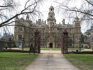
Perlethorpe cum Budby is a civil parish in the Newark and Sherwood district, within the county of Nottinghamshire, England. The overall area had a population of 172 at the 2021 census. The parish lies in the north west of the county and district. It is 125 mi (201 km) north of London, 8 mi (13 km) north east of Mansfield and 20 mi (32 km) north of the city of Nottingham. The parish and wider area is at the heart of Sherwood Forest, which is associated with the Robin Hood legend. Thoresby Hall, which is a notable ducal country house and estate is also within the boundaries of the parish.

Bilsthorpe Moor is a hamlet in the civil parish of Bilsthorpe, in the Newark and Sherwood district of Nottinghamshire, England. It is 120 miles north of London, 13 miles north east of the city of Nottingham, and 5 miles south of Ollerton, and close to the junction of the A614 and A617 roads.

References

  1. 1 2 UK Census (2021). "2021 Census Area Profile – Lindhurst parish (E04007924)". Nomis. Office for National Statistics . Retrieved 11 January 2024.
  2. "Nomis - Nomis - Official Labour Market Statistics". www.nomisweb.co.uk. Retrieved 29 October 2020.
  3. "Custom report - Nomis - Official Census and Labour Market Statistics". www.nomisweb.co.uk.
  4. "FOREST STONE, LYNDHURST, Mansfield - 1370190 | Historic England". historicengland.org.uk. Retrieved 8 November 2020.
  5. "Lindhurst (United-Kingdom) - Wind farms - Online access - The Wind Power". www.thewindpower.net. Retrieved 6 November 2020.
  6. "Five turbine wind farm opened at Rainworth". BBC News. 10 November 2010. Retrieved 6 November 2020.
  7. "Nottinghamshire | wind power wins!". www.indymedia.org.uk. Retrieved 8 November 2020.
  8. 1 2 3 GENUKI. "Genuki: Lindhurst, Nottinghamshire". www.genuki.org.uk. Retrieved 6 November 2020.
  9. 1 2 Gaunt, Andy (5 August 2012). "Archaeology and History of Medieval Sherwood Forest: Lyndhurst Wood- the 'chief wood of Sherwood'". Archaeology and History of Medieval Sherwood Forest. Retrieved 8 November 2020.
  10. "The Future of Sherwood's Past". www.mercian-as.co.uk. Retrieved 7 November 2020.
  11. 1 2 "Nottinghamshire history > The History of Mansfield (1894)". www.nottshistory.org.uk. Retrieved 8 November 2020.
  12. "Fountain Dale moat, Lindhurst - 1008627 | Historic England". historicengland.org.uk. Retrieved 8 November 2020.
  13. "Property for Sale Nr. Mansfield NOTTINGHAMSHIRE | Rural Scene". www.ruralscene.co.uk. Retrieved 7 November 2020.
  14. "Heritage Impact Assessment - Mansfield District Local Plan".