
West Warwick is a town in Kent County, Rhode Island, United States. The population was 31,012 at the 2020 census.
Watch Hill is an affluent coastal neighborhood and census-designated place in the town of Westerly, Rhode Island. The population was 154 at the 2010 census. It sits at the most-southwestern point in Rhode Island. It came to prominence in the late 19th and early 20th century as an exclusive summer resort, with wealthy families building sprawling Victorian-style "cottages" along the peninsula. Watch Hill is characterized by The New York Times as a community "with a strong sense of privacy and of discreetly used wealth," in contrast with "the overpowering castles of the very rich" in nearby Newport.

Saunderstown is a small village and historic district in the towns of Narragansett and North Kingstown in Washington County, Rhode Island, United States. Saunderstown has its own post office with the ZIP Code of 02874, which also includes a small part of South Kingstown. Its population is 6,245.

Roger Williams Park is an elaborately landscaped 427-acre (173 ha) city park in Providence, Rhode Island and a historic district listed on the National Register of Historic Places. It is named after Roger Williams, the founder of the city of Providence and the primary founder of the state of Rhode Island.

Swan Point Cemetery is a historic rural cemetery located in Providence, Rhode Island, United States. Established in 1846 on a 60-acre (0.24 km2) plot of land, it has approximately 40,000 interments.

Henry Frederick Lippitt was a member of the prominent Lippitt family, which made its fortune in the textile business, and served as United States Senator from Rhode Island.

The Governor Henry Lippitt House is a historic house museum at 199 Hope Street on the East Side of Providence, Rhode Island. A National Historic Landmark, it is one of the finest Italianate mansion houses in the state, and considered one of the best-preserved examples of Victorian-era houses in the United States. It is notable for its association with Henry Lippitt (1818–91), a wealthy textile magnate who was the 33rd Governor of Rhode Island. The house is owned by Preserve Rhode Island, and is open to the public for tours seasonally or by appointment.

Union Village or "Bank Village" is a village and historic district located in North Smithfield and Woonsocket, Rhode Island on Rhode Island Route 146A. Union Village developed because it was at the cross roads of old Great Road and Pound Hill Road.
Frederick Lippitt was an American military officer, attorney, politician, public servant and philanthropist.

Saylesville is a village and historic district in Lincoln, Rhode Island.

The Alfred Drowne Road Historic District of Barrington, Rhode Island, encompasses a suburban area developed between about 1860 and 1910, a period of significant suburban growth in Barrington spurred by the connection of the town by rail to Providence in 1855. This 27-acre (11 ha) residential area was before that time farmland owned by Alfred Drown, whose c. 1830 farmhouse still stands at 13 Alfred Drowne Road. The house of his son Benjamin, built c. 1856, is at number 27. The district includes properties along Alfred Drowne Road, as well as a few properties on Washington Street and Annawamscutt Road which are immediately adjacent.

The Dexter Arnold Farmstead is a historic farmstead on Chopmist Hill Road in Scituate, Rhode Island. The main house, a 2+1⁄2-story wood-frame structure five bays wide, with a large central chimney, was built in 1813. The 3.6-acre (1.5 ha) property also has five outbuildings which appear to be near contemporaries to the house, a relative rarity in rural Rhode Island. The main barn survived into the 20th century, but was destroyed by the New England Hurricane of 1938. The property also includes a small family cemetery. The house, built by Dexter Arnold in land belonging to his father, remained in family hands until 1975.
The Austin Farm Road Agricultural Area is a rural historic district in Exeter, Rhode Island. The district is bounded on the east by Interstate 95, on the north by the town line, on the south by Austin Farm Road, and on the west by a north-south line through Austin Farm Pond. This agricultural area is relatively little altered since the late 19th century, despite the proximity of the interstate. It includes the farm complex built up by John Austin in the 19th century, which continues to see active use, and the site of an older farm complex, reduced to just the farmhouse, which predates Austin's acquisition of the property. In addition to the farm buildings, it includes a chapel and school house built or maintained by Austin.

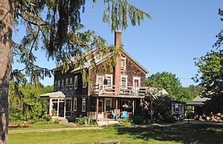
The Sheffield House is an historic house on Beach Road in the Quonochontaug section of Charlestown, Washington County, Rhode Island. It is a 1+1⁄2-story, wood-shingled, gambrel-roofed residence, with a large, stone chimney; a simple entry at the left side of a 3-bay, south-facing façade; and a 1-story wing at the left side. The house was probably built between 1685 and 1713, probably by Joseph Stanton (1646-1713), the third son of Thomas Stanton (1616-1677), one of the original settlers in this area. Joseph's son Thomas, had no surviving sons, so the farm was deeded in 1753 to his son-in-law Nathaniel Sheffield (1712-1790) the husband of Rebecca Stanton (1713-1775). Today the house is called the Stanton-Sheffield house.

Wyoming is a village and census-designated place on the Wood River in southern Rhode Island, primarily in the town of Richmond, Rhode Island, but extending north across the river into the town of Hopkinton, Rhode Island. The population was 270 at the 2010 census. It is the site of the Wyoming Village Historic District and a post office assigned ZIP code 02898.
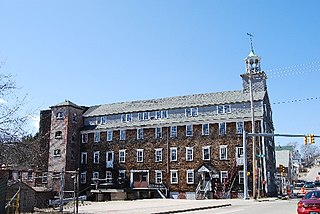
The Lippitt Mill is an historic mill at 825 Main Street in West Warwick, Rhode Island.

The Martin House is a historic house in Seekonk, Massachusetts, United States.

The Young-Shaw House was a historic farmhouse located near Sarahsville, Ohio, United States. A simple building originally home to a wealthy farmer, it was passed down through numerous generations of the original owner's family, and it has been named a historic site.
Christopher Lippitt was a prominent Revolutionary War officer and founder one of the earliest textile mills in Rhode Island.
Lippitt, Rhode Island is a village within the town of West Warwick, Rhode Island.


