The United Nations Educational, Scientific and Cultural Organization (UNESCO) World Heritage Sites are places of importance to cultural or natural heritage as described in the UNESCO World Heritage Convention, established in 1972. [1] Cultural heritage consists of monuments (such as architectural works, monumental sculptures, or inscriptions), groups of buildings, and sites (including archaeological sites). Natural features (consisting of physical and biological formations), geological and physiographical formations (including habitats of threatened species of animals and plants), and natural sites which are important from the point of view of science, conservation, or natural beauty, are defined as natural heritage. [2] Botswana accepted the convention on 23 November 1998. [3] There are two World Heritage Sites in Botswana, with a further seven on the tentative list. [3]
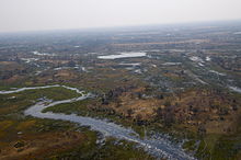
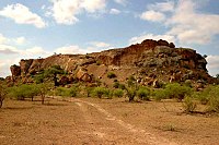
The first site in Botswana to be inscribed to the list was Tsodilo Hills in 2001. [3] The most recent site listed was the Okavango Delta in 2003. The Okavango Delta was listed for being a natural site, and Tsodilo was listed for being a cultural site. [3] Botswana has never served on the World Heritage Committee. [3] The Okavango Delta became the one thousandth World Heritage Site worldwide. [4]
UNESCO lists sites under ten criteria; each entry must meet at least one of the criteria. Criteria i through vi are cultural, and vii through x are natural. [5]
Site | Image | Location (district) | Year listed | UNESCO data | Description |
---|---|---|---|---|---|
Tsodilo | ![]() | Ngamiland | 2001 | 1021; i, iii, vi (cultural) | Tsodilo has one of the highest concentrations of rock art in the world. Along with rock art, the hills also provide shelter inside the caves. For thousands of years, the outcrops of the site have been settled on by humans while leaving marks of their presence through the form of rock art over several millennia. These outcrops have significant religious symbolism for the communities living in this environment. Tsodilo is formed of massive quartzite formations. Over 4,500 paintings are preserved at Tsodilo. Its archaeological record is able to give an account of human activities for at least 100,000 years, though not continuously. Local communities consider Tsodilo as a place of worship visited by ancestral spirits. Its preservation is usually attributed to Botswana's low population density, and its high resistance to erosion because of its quartzitic rock. [6] |
Okavango Delta | ![]() | Ngamiland | 2014 | 1432; vii, ix, x (natural) | The Okavango Delta is Africa's third largest alluvial fan, and largest endorheic delta. The area includes permanent swamps and marshlands. It is one of few large inland deltas that have no outlet to the sea. About 40% of land is protected within the Moremi Game Reserve. Mining activities are not allowed within the property. Its waters are considered to transform the dry Kalahari Desert into a scenic landscape. It contains some of the world's most endangered species like the cheetah and the black and white rhinoceros. It is also referred to as an example of the complexity of climatic, hydrological, and biological processes. [7] |
In addition to sites inscribed on the World Heritage List, member states can maintain a list of tentative sites that they may consider for nomination. Nominations for the World Heritage List are only accepted if the site was previously listed on the tentative list. [8] Botswana maintains seven properties on its tentative list. [3]
Site | Image | Location (district) | Year listed | UNESCO criteria | Description |
---|---|---|---|---|---|
Toutswemogala Hill Iron Age Settlement | — | Central | 1999 | ii, iii, iv (cultural) | Toutswemogala Hill is an elongated flat topped hill around 50 kilometres (31 mi) north of the village of Palapye. It rises around 50 metres (160 ft) around the surrounding mopane field. In the early states of Southern Africa, the hill's main economic source was from cattle keeping. [9] |
Central Kalahari Game Reserve | | Ghanzi and Kweneng | 2010 | v, vii, ix (mixed) | This game reserve located in central Botswana is part of the Kalahari Basin. It was established in 1971 to protect its series of pans, dry valleys, and game. It is inhabited by many indigenous hunter-gatherers such as the San and the Bakgalagadi. [10] |
Chobe Linyanti System | ![]() | Chobe | 2010 | ix, x (natural) | The Chobe Linyanti System consits of the Linyati River in the north along with the Chobe National Park in the east. The park has one of the largest game concentrations in Africa, and is considered to be the most diverse park in Botswana. It is also considered to be one of the most distinct ecosystems in Africa. [11] |
Mapungubwe Cultural Landscape | ![]() | Central | 2010 | ii, iii, iv, v (cultural) | This landscape is situated in the physiographic region known as the veld in a valley that consists of the confluence of the Shashe and Limpopo rivers. The tuli elephant, lion, leopard, and the spotted hyena roam the place. The wildlife in the area was able to provide necessary resources for trading in the region. [12] |
Gcwihaba Caves | — | Ngamiland | 2010 | vii, viii (natural) | This site is located in the northwest of the country. These caves are part of several related groups of dolomite hills. All of these hills have caves. These are generally called the Gcwihaba Caves. [13] |
Makgadikgadi Pans Landscape | ![]() | Central | 2010 | v, vii, viii, x (mixed) | This landscape is located in the north east of the Central Kalahari Game Reserve. It is also located to the south east of the Okavango Delta. It is linked to the delta through the Boteti River. The pans are some of the largest in the world. It was formerly one of the largest inland seas in the world. The area is resembled through its stone age to historic sites. The region includes Acheulean tools, along with middle and late stone age tools. [14] |
Tswapong Hills Cultural Landscape | ![]() | Central | 2010 | v, vi (cultural) | This landscape is located in the eastern part of the Central District. Hard rock has protected the area from significant erosion, therefore resulting in high elevation from the nearby plains. The western part of the hill range boasts the remains of the ancient Ngwato capital, along with the church built with the leadership of kgosi Khama III. Over 345 species of butterfly live in the hills, along with other animals like the Cape vulture, bovids, fish and crabs. The area has archaeological material like rock art, and iron smelting sites. [15] |