History of Gaborone

Last updated
Historical population
YearPop.±%
19643,855    
197117,718+359.6%
198159,657+236.7%
1991133,468+123.7%
2001186,007+39.4%
2011231,592+24.5%
[1] [2] [3] [4] [5]

[6]

[7]

The history of Gaborone began with archaeological evidence in the area around Gaborone dating back to 400 BCE, [8] and the first written accounts of Gaborone are from the earliest European settlers in the 19th century. Since the 1960s, when Botswana gained its independence from Britain and Gaborone became the capital, the city has grown from a small village in the Botswana scrubland to a major center in southern Africa.

Contents

Early history

Evidence shows that there have been inhabitants along the Notwane River for centuries, all the way back to the Middle Stone Age. [9] The area that is now modern-day Botswana was inhabited exclusively by the Khoikhoi pastoralists, who valued cattle because of nutritional benefits, [10] until around the 8th century CE when the Toutswe people arrived in Botswana. The Toutswe (also called the Toutswemogala society after their main settlement, Toutswemogala) settled in the area around Palapye and Serowe, and they introduced the cultivation of sorghum and millet. [11] By 900 CE, the Toutswe culture started to gain a foothold in Botswana. Like the earlier Khoikhoi people, the Toutswe society heavily centered around cattle: kraals, or cattle enclosures, have been found in numerous locations around eastern Botswana. In this society, wealth and hierarchy was based on the number of cows, not in the amount of gold like the adjacent Mapungubwe society. [12] The Toutswe engaged in long-distance trade, acquiring beads and porcelain. [10] The Toutswe culture started to collapse in the 13th century due to overgrazing and drought; however the prestige of cattle remained in Botswana society. [12]

19th century

German map of Matabeleland with the city of Gaborone (referred to as Moschaweng) in the lower left-hand corner on the border between the Bechuanaland Protectorate (pink) and the South African Republic (bright yellow) Matabeleland.png
German map of Matabeleland with the city of Gaborone (referred to as Moschaweng) in the lower left-hand corner on the border between the Bechuanaland Protectorate (pink) and the South African Republic (bright yellow)

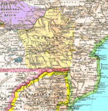
The Mfecane (the crushing or scattering in Zulu) is a period in the early 19th century marked by major upheavals and migrations of the tribes in southern Africa. Before the arrival of Europeans to the area, the Batswana were the dominant ethnic group in the southern half of Botswana, subjugating the Bakgalagadi people and the Khoikhoi to become malata or servants. In the 1830s, the Boers embarked on the Great Trek from the Cape Colony towards the northeast. This movement caused the Amandebele people, led by Mzilikazi, to attack the Batswana as they moved northwards to present-day Zimbabwe in the 1830s, forcing them to pay tribute. The Bakololo people also fought with the Batswana during this time when they migrated to Barotseland in modern-day western Zambia. Along with the Bakololo and the Amandebele, the Boers also created skirmishes with the Batswana. Kgosi Setshele I ( kgosi means chief in Tswana) of the Bakwena led the Batswana side during the Battle of Dimawe from 1852–1853. An agreement was signed between the Boers and the Batswana in January 1853. [12]

During this time, European missionaries from the London Missionary Society, such as David Livingstone and Robert Moffat, spread Christianity throughout the region. David Livingstone started the first church and school in 1845 at the Kolobeng Mission, near Gaborone. [12]

In the 1880s, Kgosi Gaborone of the Batlokoa clan left the Magaliesberg area in the South African province of North West to settle in the southeastern part of Botswana and called the settlement Moshaweng. [9] There is an unrelated Moshaweng in the Kweneng District northwest of Gaborone. The city that Kgosi Gaborone founded was first called Gaborone's Village by the first European settlers. It was later shortened to Gaberones. Cecil Rhodes, a mining magnate and founder of the De Beers mining company, built a fort for colonial administration across the river from Gaberones. [13] The fort was where Rhodes planned the Jameson Raid during the Second Boer War. [9] The site of the fort became Gaborone and the city of Gaberones became Tlokweng. [13]

After gold was discovered in South Africa in 1871, Khama III of the Bamangwato tribe made an alliance with the United Kingdom against advancing Boer gold miners. On 31 March 1885, United Kingdom created the Bechuanaland Protectorate from the land north of the Molopo River to the Caprivi Strip of German South-West Africa. The area south of the Molopo River became part of South Africa. [12]

Until the 1890s, Britain ruled Bechuanaland indirectly, letting the dikgosi (plural of kgosi) rule themselves. Things changed when Cecil Rhodes established the British South Africa Company with a government charter. Rhodes wanted to have control over the entire southern African region. Three dikgosi, Khama III, Sebele I, and Bathoen I, traveled to Great Britain in 1895 to ask Queen Victoria not to incorporate Botswana into Rhodes's company or other British colonies like Southern Rhodesia or the Cape Colony, and they proved successful. Today, in Gaborone, there is a memorial called the Three Dikgosi Monument in honor of the three chiefs who helped the founding of Bechuanaland and later Botswana. [12]

20th century

A postage stamp c.1943, the postmark reading "Gaberone's Village" Stamp Bechuanaland Protectorate 1938 6p.jpg
A postage stamp c.1943, the postmark reading "Gaberone's Village"
Rev. Derek Jones, the first mayor of Gaborone 1966 Mayor Gaborone.JPG
Rev. Derek Jones, the first mayor of Gaborone

From 1961 to 1965, the city experienced a major drought, killing more than 250.000 head of cattle. [14]

In 1965, the capital of the Bechuanaland Protectorate moved from Mafeking to Gaberones. When Botswana gained its independence, Lobatse was the first choice as the nation's capital. However, Lobatse was deemed too limited, and instead, a new capital city would be created next to Gaberones. [13] The city was chosen because of its proximity to a fresh water source, its proximity to the railway to Pretoria, and its central location among the central tribes. [15] Another reason Gaborone was picked to be capital was that it had a history of being the administrative center of Botswana. During the Second Boer War, the city served as the temporary capital of Bechuanaland while Mafikeng was under siege by the Boers. Gaborone was not affiliated with any tribe either, another reason for its designation as the capital. [16] The old colonial Gaberones became a suburb of the new Gaberones and is now known as "the Village". [13]

On 30 September 1960,1966, Bechuanaland became the eleventh British dependency in Africa to become independent. The first mayor of Gaborone was Reverend Derek Jones. [17]

The city was planned under Garden city principles with numerous pedestrian walkways and open spaces. [18] Building of Gaborone started in mid-1964. During the city's construction, the chairman of Gaberones Township Authority, Geoffrey Cornish, likened the layout of the city to a “brandy glass” with the government offices in the base of the glass and businesses in the “mall”, a strip of land extending from the base. [19]

Most of the city was built within three years, earlier than expected so the government offices could move in earlier. 2,000 workers helped construct the city, shoveling 140,000 cubic yards (110,000 m3) and making 2,500,000 blocks of concrete. [16] Buildings in early Gaborone include assembly buildings, government offices, a power station, a hospital, schools, a radio station, a telephone exchange, police stations, a post office, more than 1,000 houses [20] and apartments, a British high commission, a library, a brewery, a church, and numerous other structures. By 1966, the population of Gaborone was about 5,000 people. [16]

The city changed its name from Gaberones to Gaborone in 1969. [21]

Delivery man at Old Naledi Delivery man.jpg
Delivery man at Old Naledi

Because the city was built so quickly, there was a massive influx of labourers who had built illegal settlements on the new city's southern industrial development zone. These settlements were named Naledi. Naledi literally means the star, but could also mean under the open sky or a community that stands out from all others. In 1971, because of the growth of illegal settlements, the Gaborone Town Council and the Ministry of Local Government and Lands surveyed an area called Bontleng, which would contain low-income housing. However, Naledi still grew, and the demand for housing was greater than ever. In 1973, the Botswana Housing Corporation (BHC) built a "New Naledi" across the road from the "Old Naledi". Residents from Old Naledi would be moved to New Naledi. However, the demand for housing increased yet again; moreover, the residents who relocated to New Nadeli disliked the houses. The problem was solved in 1975 when Sir Seretse Khama, the president of Botswana, rezoned Naledi from an industrial zone to a low-income housing area. [22]

In the 1970s, the city was involved in the conflicts of the Rhodesian Bush War and South Africa under apartheid. Thousands of South Africans and Rhodesians crossed the border and into the country where they either stayed in Gaborone or Francistown, or flew to Zambia or Tanzania to participate in anti-apartheid movements or freedom-fighting activities with Joshua Nkomo's Zimbabwe African People's Union. The runaways put economic stress on the city, caused the standard of living to decrease, and created tensions not only between the governments of Botswana, South Africa, and Rhodesia but also between the citizens within Botswana and the refugees. [23] A quote from a government official summarizes the conundrum:

In this part of the country the Botswana people are the refugees. When they see the assistance flowing into the camps, they want it also. They become beggars.

J. H. Munamati [24]

Gaborone has experienced a multitude of attacks by the South African military in the 1980s. On 13 May 1983, South Africa sent helicopters to attack the army base outside of Gaborone. [25] On 14 June 1985, South Africa attacked an anti-apartheid group in the Raid on Gaborone. The raids resulted in twelve civilian deaths. After the raid, the United States withdrew its ambassador to South Africa. South African forces also ambushed the Botswana Defence Force barracks just northwest of the city towards Mogoditshane on 19 May 1986; a government worker was killed during the helicopter-borne attack. South Africa claimed that they were rooting out African National Congress terrorists. [26] Another attack on 28 March 1988 left four dead in Gaborone. [27]

Gaborone gained the title of city in 1986 after being classified as a town. [28]

In 1992, the Southern African Development Community (SADC) was founded in Gaborone, uniting the economies of the member nations. [10]

After the 1994 General Elections, riots started in Gaborone because of high unemployment and other issues. [29]

Today, Gaborone is growing very rapidly. The city originally planned on 20,000 citizens, [16] but by 1992, the city had 138,000 people. This has led to many squatter settlements on undeveloped land. [30]

See also

Related Research Articles

Botswana Country in Southern Africa

Botswana, officially the Republic of Botswana, is a landlocked country in Southern Africa. Botswana is topographically flat, with up to 70 percent of its territory being the Kalahari Desert. It is bordered by South Africa to the south and southeast, Namibia to the west and north, and Zimbabwe to the northeast. It is connected to Zambia across the short Zambezi River border by the Kazungula Bridge.

The Batswana, a term also used to denote all citizens of Botswana, refers to the country's major ethnic group. Prior to European contact, the Batswana lived as herders and farmers under tribal rule.

Mafikeng, officially known as Mahikeng and previously Mafeking, is the capital city of the North West province of South Africa.

Gaborone Capital and the largest city of Botswana

Gaborone is the capital and largest city of Botswana with a population of 231,626 based on the 2011 census, about 10% of the total population of Botswana. Its agglomeration is home to 421,907 inhabitants at the 2011 census.

Khama III King (Kgosi) of the Bangwato people of central Botswana (r. 1875–1923)

Khama III (1837?–1923), referred to by missionaries as Khama the Good also called Khama the Great, was the Kgosi of the Bangwato people.

Tswana people Bantu ethnic group in Southern Africa

The Tswana are a Bantu-speaking ethnic group who are native to Southern Africa. The Tswana language is a principal member of the Sotho-Tswana language group. Ethnic Tswana made up approximately 85% of the population of Botswana in 2011.

Bechuanaland Protectorate British protectorate in southern Africa, became Botswana in 1966

The Bechuanaland Protectorate was a protectorate established on 31 March 1885, by the United Kingdom of Great Britain and Ireland in Southern Africa. It became the Republic of Botswana on 30 September 1966.

Palapye is a growing town in Botswana, situated about halfway between Francistown and Gaborone. Over the years its position has made it a convenient stopover on one of Southern Africa's principal north–south rail and road routes.

Culture of Botswana

Besides referring to the language of the dominant people groups in Botswana, Setswana is the adjective used to describe the rich cultural traditions of the Batswana - whether construed as members of the Setswana ethnic groups or of all citizens of Botswana. the Batswana believe in the rich culture of Botho-Ubuntu, ‘‘People are not individuals, living in a state of independence, but part of a community, living in relationships and interdependence.’ Batswana believe in working together and in being united. There are different ethnic groups in the Tswana tribe among them the Barolong, Bakwena, Bakgatla, Baphuthing, Bataung, Bangwaketse, Batawana, Bahurutshe,Balete, Bakalanga, Bayei, Bambukushu, Baubiya, Basarwa, Baherero,Bakgothu, Batswapong and Batshweneng. All these tribes believe in different customs but are still guided by the Tswana culture and way which makes them have similarities. The languages are still the same but differ slightly from one area to the other or by dialects but they are all regarded as Setswana. The Batswana are based in the Northwest Province of the Republic of South Africa and Botswana.

Shoshong is a town in Botswana, formerly the chief settlement of the eastern Bamangwato.

The Roman Catholic Diocese of Gaborone is a diocese located in the city of Gaborone, Botswana, in the Ecclesiastical province of Pretoria in South Africa. The motto of the diocese is Deus Caritas Est, which means "God is love."

Outline of Botswana Overview of and topical guide to Botswana

The following outline is provided as an overview of and topical guide to Botswana:

Kgosi Gaborone

Gaborone was a kgosi (chief) of the Tlokwa, a tribe of the larger Tswana people in what is now Botswana. He became the tribe's chief around 1880, after the death of his father, and secured the Tlokwa's status as the "smallest independent tribal unit" in the Bechuanaland Protectorate. He gave his name to the city of Gaborone, Botswana's current capital.

<i>Three Dikgosi Monument</i> Monument in Gaborone, Botswana

The Three Dikgosi Monument is a bronze sculpture located in the Central Business District of Gaborone, Botswana. The statues depict three dikgosi : Khama III of the Bangwato, Sebele I of the Bakwena, and Bathoen I of the Bangwaketse. Events are held at the monument such as the 2008 Miss Independence Botswana. A study conducted between January and August 2007 shows that the monument is the most visited tourist destination in Gaborone.

The Battle of Dimawe was fought between several Batswana tribes and the Boers in August 1852. Under the command of Kgosi Setshele I of the Bakwena tribe, the Batswana were victorious at Dimawe Hill.

<i>Kgosi</i> Hereditary leader of a Batswana tribe

A kgosi is the title for a hereditary leader of a Batswana tribe.

Bogosi Act Legislation in Botswana defining the office of bogosi or "chieftainship"

The Bogosi Act is a piece of legislation in Botswana that defines the office of bogosi or "chieftainship" among Botswana's various tribes. The act was written in response to the Balopi Commission recommendation that the Constitution of Botswana replace all references of the word "chief" to the Setswana word kgosi. The Bogosi Act replaces the earlier Chieftainship Act of 1987.

The following is a timeline of the history of the city of Gaborone, Botswana.

Bathoen I was a kgosi of the Ngwaketse people (1889-1910). Together with Khama III and Sebele I he is credited with saving the young British Bechuanaland Protectorate, a predecessor of Botswana, from being absorbed by expansionist forces in the 1890s.

Kgosi Puso Gaborone is the paramount chief (Kgosi) of the BaTlokwa tribe of Tlokweng in Botswana. As of 2021, he serves as the elected chairperson of Botswana's Ntlo ya Dikgosi, a position he has held since 2009.

References

  1. "BOTSWANA STATISTICAL YEAR BOOK 2010" (PDF). Statistics Botswana. Gaborone: Central Statistics Office. December 2011. Archived from the original (PDF) on 4 September 2015. Retrieved 25 February 2012.
  2. Maundeni, Zibani (June 2004). Mapping Local Democracy in Gaborone City (PDF). Botswana Association of Local Authorities. ISBN   99912-564-2-3. Archived (PDF) from the original on 9 March 2012. Retrieved 3 August 2010.
  3. Central Statistics Office. "Table 1.6: Distribution of Population in Urban Settlements: 1971– 2001 Censuses". Gaborone, Botswana. Retrieved 27 December 2009.
  4. "The Population of Towns, Villages and Associated Localities" (PDF). 2011 Population and Housing Census. Gaborone: Statistics Botswana. June 2012. Archived from the original (PDF) on 4 September 2015. Retrieved 14 June 2012.
  5. Central Statistics Office (January 2009). "BOTSWANA DEMOGRAPHIC SURVEY 2006" (PDF). Gaborone, Botswana. Retrieved 3 July 2010.[ permanent dead link ]
  6. Central Statistics Office (January 2009). "BOTSWANA DEMOGRAPHIC SURVEY 2006" (PDF). Gaborone, Botswana. Retrieved 12 July 2019.
  7. statsbots.org.bw (2015). "Cities and Towns Population and Housing Census 2011" (PDF). Gaborone, Botswana. Retrieved 12 July 2019.
  8. Shillington, Kevin (1995). History of Africa. New York, New York, USA: Palgrave Macmillan. ISBN   0-312-12598-4.
  9. 1 2 3 Hardy, Paula; Firestone, Matthew D. (2007). "Gaborone". Botswana & Namibia. Lonely Planet. pp. 75–88. ISBN   978-1-74104-760-8 . Retrieved 2009-08-04.
  10. 1 2 3 Collins, Robert O.; Burns, James McDonald (2007). "The peoples and states of southern Africa". A history of Sub-Saharan Africa. Cambridge University Press. pp. 160–161, 389. ISBN   978-0-521-86746-7 . Retrieved 2010-07-13.
  11. Hall, Martin (1990). "Toutswe, Mapungubwe and the East coast trade". Farmers, Kings and Traders: The People of Southern Africa 200-1860. Chicago, Illinois, USA: University of Chicago Press. pp. 85–86. ISBN   0-226-31326-3 . Retrieved 2010-07-13.
  12. 1 2 3 4 5 6 Shillington, Kevin (2005). "Encyclopedia of African History: A - G.. 1". In Shillington, Kevin (ed.). Encyclopedia of African History. Vol. 1. CRC Press. pp. 161–163, 166–167, 701–702, 704. ISBN   1-57958-453-5 . Retrieved 2010-07-13.
  13. 1 2 3 4 Njeru, Purity (2009). "History of Gaborone". Nairobi, Kenya: The African Executive. Archived from the original on 2011-07-07. Retrieved 2009-08-04.
  14. "Disaster State Nears In South Africa Drought". Ocala Star-Banner. Johannesburg, South Africa. Associated Press. 1965-06-30. p. 3. Retrieved 2010-07-14.
  15. Seth, Willie (2008). "Major urban centres". Botswana and Its People. Godfrey Mwakikagile. pp. 44–46. ISBN   978-0-9814258-7-0 . Retrieved 2009-08-04.
  16. 1 2 3 4 "Gaberones Developed As Capital City of New State, Botswana". Nashua Telegraph. Gaberones, Bechuanaland: N.Y. Times News Service. Times of London Dispatch. 1966-11-09. p. 33. Retrieved 2010-07-14.
  17. Grant, Sandy (2009-06-18). Our Heritage. Vol. 26. Gaborone, Botswana: Mmegi Online . Retrieved 2009-08-06.
  18. Keiner, Marco; Zegras, Christopher; Schmid, Willy A. (2004). Keiner, Marco; Zegras, Christopher; Schmid, Willy A.; et al. (eds.). From understanding to action: sustainable urban development in medium-sized cities in Africa and Latin America. Springer. pp.  19, 63, 68, 93. ISBN   978-1-4020-2879-3 . Retrieved 2009-08-06.
  19. Paine, David J. (1966-04-15). "Capital City Being Built On Virgin Soil". Eugene Register-Guard. Gaberones, Bechuanaland. Associated Press. section D, p. 3. Archived from the original on 2013-01-02. Retrieved 2010-07-11.
  20. killion (2009-06-29). "The Unsustainable urban growth of Gaborone City, Botswana". Boidus: Blogs. Archived from the original on 2013-07-25. Retrieved 2009-08-04.
  21. "Regions Given New Spelling". Spokane Daily Chronicle. Gaborone, Botswana. Associated Press. 1969-12-22. p. 11. Retrieved 2010-07-11.
  22. Van Nostrand, John Cornelius (1982). "Old Naledi: History of Settlement". Old Naledi, the village becomes a town: an outline of the Old Naledi Squatter Upgrading Project, Gaborone, Botswana. James Lorimer & Company. pp. 13–15. ISBN   978-0-88862-650-9 . Retrieved 2009-09-19.
  23. Younghusband, Peter (1977-03-02). "The Pied Pipers of Africa". The Sydney Morning Herland. Gaberones, Botswana. p. 7. Retrieved 2010-07-14.
  24. Arnett, Peter (1979-04-24). "The World Turns a Cold Shoulder". The Palm Beach Post. Gaberones, Botswana. The Associated Press. Retrieved 2010-07-14.
  25. "South Africa conducts raids on cities in three countries". The Southeast Missourian. Johannesburg, South Africa. Associated Press. 1983-05-13. p. 3. Retrieved 2010-07-14.
  26. Cowell, Alan (1986-05-20). "South Africa raids rebels across border". Pittsburgh Post-Gazette. Johannesburg, South Africa. New York Times News Service. pp. 1–2. Retrieved 2010-07-14.
  27. "South African army kills four in raid in Botswana". The Lewiston Journal. Gaborone, Botswana. Associated Press. 1988-03-28. p. 7A. Retrieved 2010-07-14.
  28. Embassy of Botswana in Tokyo, Japan. "Gaborone Capital City & The Surroundings". Cities and Towns. Archived from the original on 2011-01-28. Retrieved 2010-07-13.
  29. LeVert, Suzanne (2007). Botswana . Marshall Cavendish. pp.  15, 27–28, 105. ISBN   978-0-7614-2330-0 . Retrieved 2009-08-06.
  30. Carr, Michael (1997). "The form and future shape of the modem city". New patterns: process and change in human geography (2nd ed.). Nelson Thornes. p. 224. ISBN   978-0-17-438681-0 . Retrieved 2009-08-06.

Bibliography