| List of caves in Bosnia and Herzegovina | |
|---|---|
 Govještica a.k.a. Dugovještica | |
| Location | Bosnia and Herzegovina |
| Geology | Karst caves, Dinarides |
| Website | www.centarzakrs.ba |

Location in Bosnia and Herzegovina
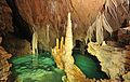
Following is a list of caves in Bosnia and Herzegovina. Most of the country's caves belong to Dinaric Alps system and are karst caves, with complex karstic features and endemic biodiversity. [1] [2] [3]
| Image | Name | Dimension | Location | Notes |
|---|---|---|---|---|
 | Badanj | loc | Upper Paleolithic site | |
 | Banja Stijena | m | loc | (a.k.a. ) Mračna Cave |
 | Dimšina Cave | m | loc | Bijambare cave complex, Bijambare Nature park |
 | Middle Cave | m | loc | Bijambare cave complex, Bijambare Nature park |
 | Đurićina Cave | m | loc | Bijambare cave complex, Bijambare Nature park |
 | Duman Cave | m | loc | The Bistrica's Duman wellspring cave |
 | Dabarska 1 | m | loc | The Dabar wellspring |
 | Dabarska 2 | m | loc | The Dabar wellspring |
 | Djevojačka | m | loc | note |
 | Dejanova Pećina | m | Bileća | Dejan's Cave the Trebišnjica main wellspring |
 | Dobreljska | m | loc | |
| Fajtovačka | m | loc | note | |
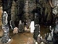
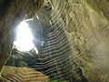
 | Govještica Cave | m | loc | (a.k.a. Dugovještica Cave) |
 | Hrustovačka | m | loc | note |
| Hukavica Cave | m | loc | note | |
 | Klokočevica Cave | m | Bjelašnica | note |
| Ledenica | m | loc | note | |
| Ledenjača Cave | m | loc | note | |
| Megara | m | loc | note | |
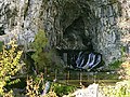
| Vrelo Miljacke | m | loc | The Mokranjska Miljacka wellspring cave | |
 | Novakova | m | Pale | |
 | Orlovača | m | loc | note |
 | Pavlova | m | loc | Nature park |
| Podlipe | m | loc | note | |
 | Peć Mlini Cave | m | Peć Mlini | The Trebižat river wellspring cave |
 | Rastuša | m | loc | note |
 | Ravlića | m | loc | note |
 | Titova (Drvar) | m | Drvar | note |
| Titova (Plahovići) | m | Plahovići | note | |
| Vaganska | m | loc | note | |
| Vilina Pećina | m | Ključ, Cerničko Polje | note | |
 | Vjetrenica Cave | m | Ravno | note |
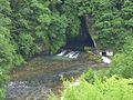
 | Vrelo Bune Cave | m | Blagaj, Mostar | The Buna river wellspring cave |
 | Vrelo Krušnice Cave | m | Bosanska Krupa | note |
| Kovači estavelle | m | Kovači, Duvanjsko Polje | note | |
| Zelena Cave | m | loc | note |
