List of largest cities in the Organisation of Islamic Cooperation member countries

Last updated

This is a list of the largest cities in the Organisation of Islamic Cooperation member states, based on the United Nations World Urbanization Prospects report (2010 population estimates from the report's 2007 revision). [1]

Urban agglomerations
RankCityImagesPopulationCountryStatistical concept [2] Area (km2) [3]
1 Jakarta [4]
Jakarta Panorama.jpg
30,214,303Flag of Indonesia.svg  Indonesia Urban agglomeration [5] 6,392
2 Karachi [6]
EFU Life By Asif Akbar.jpg
24,700,000Flag of Pakistan.svg  Pakistan Urban agglomeration4,966
3 Dhaka [7]
GulshanDhaka.jpg
22,690,116Flag of Bangladesh.svg  Bangladesh Urban agglomeration2,161
4 Cairo
Towers on the Nile.jpg
18,420,000Flag of Egypt.svg  Egypt Official metropolitan area1,310
5 Lagos [8]
Lagos skyline.jpg
17,060,307Flag of Nigeria.svg  Nigeria Urban agglomeration [9] 907
6 Istanbul
LeventPano3.jpg
14,500,000Flag of Turkey.svg  Turkey Metropolitan municipality 5,343
7 Tehran [10]
Tehran from Qeytariyeh.jpg
13,532,000Flag of Iran.svg  Iran City proper1,489
8 Lahore [10]
Badshahi Mosquee, Lahore.jpg
11,126,285Flag of Pakistan.svg  Pakistan Urban agglomeration1,370
9 Bandung [4]
Modern Bragaweg (27156618256).jpg
8,199,892Flag of Indonesia.svg  Indonesia Urban agglomeration1,876
10 Faisalabad [10]
Clock Tower Faisalabad by Usman Nadeem.jpg
7,873,910Flag of Pakistan.svg  Pakistan Urban agglomeration1,097
11 Islamabad-Rawalpindi [11]
Faisal Masjid From Damn e koh.jpg
7,412,205Flag of Pakistan.svg  Pakistan Metropolitan Area6,451
12 Surabaya [4]
Ciputra World distant from Ahmad Yani Flyover 2015.jpg
7,302,283Flag of Indonesia.svg  Indonesia Urban agglomeration [5] 2,787
13 Baghdad
Baghdad Red zone.jpg
6,625,000Flag of Iraq.svg  Iraq Metropolitan area730
14 Semarang 6,544,289Flag of Indonesia.svg  Indonesia Urban agglomeration5,287
15 Kuala Lumpur [10]
FourSeasonsKL January2018.jpg
6,088,000Flag of Malaysia.svg  Malaysia Metropolitan area [5] 673
16 Riyadh [10]
Riyadh Skyline showing the King Abdullah Financial District (KAFD) and the famous Kingdom Tower .jpg
5,666,000Flag of Saudi Arabia.svg  Saudi Arabia City proper1,550
17 Khartoum [10]
Strato en Hartumo (Sudano) 003.jpg
5,185,000Flag of Sudan.svg  Sudan Urban agglomeration580
18 Ankara
Sogutozu, Ankara.jpg
5,045,083Flag of Turkey.svg  Turkey Urban agglomeration [12] 2,516
19 Gujranwala [10]
Nishan-E-Manzil Gujranwala 20140925.jpg
5,014,196Flag of Pakistan.svg  Pakistan Urban agglomeration1,556
20 Chittagong
Chittagong city skyline.jpg
5,012,000Flag of Bangladesh.svg  Bangladesh Official metropolitan area990
21 Multan [11]
Shah Rukn e Alam by M Ali Mir 03.jpg
4,745,109Flag of Pakistan.svg  Pakistan City District 3,721
22 Alexandria
Sea Of Alex.JPG
4,421,000Flag of Egypt.svg  Egypt City proper2,970
23 Casablanca 4,270,750Flag of Morocco.svg  Morocco Urban agglomeration1,615
24 Peshawar [10]
Islamia College University, Peshawar Nightview.jpg
4,269,079Flag of Pakistan.svg  Pakistan Urban agglomeration1,257
25 Abidjan
Abidjan-Plateau1.JPG
4,175,000Flag of Cote d'Ivoire.svg  Ivory Coast Urban agglomeration2,550
26 Medan [13]
Medan20150219-1.jpg
4,103,696Flag of Indonesia.svg  Indonesia Metropolitan area1,991
27 Yogyakarta
Gadjah Mada HeadOffice.jpg
4,010,436Flag of Indonesia.svg  Indonesia Urban agglomeration1,900
28 Sargodha [11]
Shaheen Enclave Sargodha.jpg
3,903,588Flag of Pakistan.svg  Pakistan City District 5,854
29 Sialkot [11]
Clock Tower, Sialkot 21.jpg
3,893,672Flag of Pakistan.svg  Pakistan City District 3,016
30 Kabul
Modern Kabul - panoramio.jpg
3,768,000Flag of Afghanistan (2013-2021).svg  Afghanistan City proper275
31 Bahawalpur [11] Noor mahal.jpg 3,668,106Flag of Pakistan.svg  Pakistan City District 24,830
32 Algiers
Mobilis - panoramio.jpg
3,500,000Flag of Algeria.svg  Algeria Urban agglomeration [14] 363
33 Mashhad nmy mshhd1.jpg 3,131,586 [15] Flag of Iran.svg  Iran City proper3,946

See also

References and notes

  1. World Urbanization Prospects, 2007 revision (online data) Archived 2009-06-18 at the Wayback Machine
  2. "World Urbanization Prospects: The 2007 Revision Population Database". Archived from the original on 2009-05-05. Retrieved 2009-12-25.
  3. The area figures are taken from individual national censuses according to the criteria and statistical concepts noted in the World Urbanization Prospects.
  4. 1 2 3 "Indonesia: Jawa" . Retrieved 2017-07-05.
  5. 1 2 3 Data refer to the functional urban area, that is, contiguous areas which are consistently urban in character as indicated by levels of population density, economic functions and facilities.
  6. "Population explosion: Put an embargo on industrialisation in Karachi". 6 October 2013.
  7. Desk, Tribune (2022-01-14). "Dhaka ranks world's sixth most populous city". Dhaka Tribune . Archived from the original on 2023-01-15. Retrieved 2023-01-15.
  8. "Lagos State Government". Archived from the original on 2015-10-18. Retrieved 2016-02-21.
  9. Data refer to Lagos State
  10. 1 2 3 4 5 6 7 8 http://www.demographia.com/db-worldua.pdf [ bare URL PDF ]
  11. 1 2 3 4 5 "Pakistan: Provinces and Major Cities - Population Statistics, Maps, Charts, Weather and Web Information". citypopulation.de.
  12. Ankara includes Altindag, Cankaya, Etimesgut, Golbasi, Keçioren, Mamak, Sincan and Yenimahalle
  13. "Indonesia: Provinces, Regencies, Cities, Districts, Communes, Settlements - Population Statistics in Maps and Charts".
  14. Data refer to the Governorate of Grand Algiers.
  15. "Archived copy" (PDF). Archived from the original (PDF) on 2014-07-03. Retrieved 2008-02-27.{{cite web}}: CS1 maint: archived copy as title (link)

Related Research Articles

<span class="mw-page-title-main">Demographics of Cameroon</span>

The demographic profile of Cameroon is complex for a country of its population. Cameroon comprises an estimated 250 distinct ethnic groups, which may be formed into five large regional-cultural divisions:

<span class="mw-page-title-main">Demographics of Yemen</span>

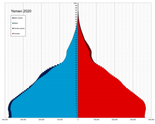
Demographic features of the population of Yemen include population density, ethnicity, education level, health of the populace, economic status, religious affiliations and other aspects of the population.

<span class="mw-page-title-main">Megacity</span> Metropolitan area with a total population in excess of ten million people

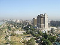
A megacity is a very large city, typically with a population of more than 10 million people. The United Nations Department of Economic and Social Affairs in its 2018 "World Urbanization Prospects" report defines megacities as urban agglomerations with over 10 million inhabitants. A University of Bonn report holds that they are "usually defined as metropolitan areas with a total population of 10 million or more people". Elsewhere in other sources, from five to eight million is considered the minimum threshold, alongside a population density of at least 2,000 per square kilometre. The terms conurbation, metropolis, and metroplex are also applied to the latter.

<span class="mw-page-title-main">Demographics of Bahrain</span>

The demographics of the population of Bahrain includes population density, ethnicity, education level, health of the populace, economic status, religious affiliations and other aspects of the population.

<span class="mw-page-title-main">Demographics of Benin</span>

The demographics of Benin include population density, ethnicity, education level, health of the populace, economic status, religious affiliations and other aspects of the population.

<span class="mw-page-title-main">Metropolitan area</span> Administrative unit of a dense urban core and its satellite cities

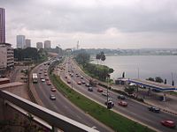
A metropolitan area or metro is a region consisting of a densely populated urban agglomeration and its surrounding territories sharing industries, commercial areas, transport network, infrastructures and housing. A metropolitan area usually comprises multiple principal cities, jurisdictions and municipalities: neighborhoods, townships, boroughs, cities, towns, exurbs, suburbs, counties, districts and even states and nations in areas like the eurodistricts. As social, economic and political institutions have changed, metropolitan areas have become key economic and political regions.

<span class="mw-page-title-main">Conurbation</span> Group of settlements linked by continuous urban area

A conurbation is a region comprising a number of metropolises, cities, large towns, and other urban areas which, through population growth and physical expansion, have merged to form one continuous urban or industrially developed area. In most cases, a conurbation is a polycentric urbanised area in which transportation has developed to link areas. They create a single urban labour market or travel to work area.

<span class="mw-page-title-main">City proper</span> Geographical area contained within the defined boundary of a city

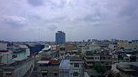
A city proper is the geographical area contained within city limits. The term proper is not exclusive to cities; it can describe the geographical area within the boundaries of any given locality. The United Nations defines the term as "the single political jurisdiction which contains the historical city centre. The term is synonymous with Central City in the United States which typically contains much of the lower income population. "

<span class="mw-page-title-main">Modal share</span> Share of mode of transport

A modal share is the percentage of travelers using a particular type of transportation or number of trips using said type. In freight transportation, this may be measured in mass.

<span class="mw-page-title-main">Secondary city</span> Type of urban hub

A secondary city is an urban hub that fills specific regional and local needs related to governance, economics, finance, education, trade, transportation. A secondary city is defined by population, area, function, and economic status, but also by their relationship to neighboring and distant cities and their socio-economic status. A secondary city may emerge from a cluster of smaller cities in a metropolitan region or may be the capital city of a province, state, or second-tier administrative unit within a country. Secondary cities are the fastest growing urban areas in lower and middle income countries, experiencing unplanned growth and development. By 2030, there will be twice as many medium size cities as there were in 1990, outnumbering the total number of megacities. According to the World Bank, secondary cities make up almost 40% of the world cities population. Many secondary cities in the Global South are expected to undergo massive expansions in the next few decades comparable to city growth in Europe and North America over the past two centuries. These cities are unique environments that generally have limited data and information on infrastructure, land tenure, and planning.