This is a list of public art in the Somerset county of England. This list applies only to works of public art on permanent display in an outdoor public space. For example, this does not include artworks in museums.
Public art is art in any media that has been planned and executed with the intention of being staged in the physical public domain, usually outside and accessible to all. Public art is significant within the art world, amongst curators, commissioning bodies and practitioners of public art, to whom it signifies a working practice of site specificity, community involvement and collaboration. Public art may include any art which is exhibited in a public space including publicly accessible buildings, but often it is not that simple. Rather, the relationship between the content and audience, what the art is saying and to whom, is just as important if not more important than its physical location.[1]
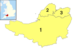
Bath and North East Somerset
Bath and North East Somerset (commonly referred to as BANES or B&NES) is a unitary authority created on 1 April 1996, following the abolition of the County of Avon.[2] It occupies an area of 220 square miles (570km2), two-thirds of which is green belt.[3] BANES stretches from the outskirts of Bristol, south into the Mendip Hills and east to the southern Cotswold Hills and Wiltshire border.[3] The city of Bath is the principal settlement in the district, but BANES also covers Keynsham, Midsomer Norton, Radstock and the Chew Valley. BANES has a population of 170,000, about half of whom live in Bath, making it 12times more densely populated than the rest of the district.[3]
This page is based on this Wikipedia article Text is available under the CC BY-SA 4.0 license; additional terms may apply. Images, videos and audio are available under their respective licenses.