List of public art in Wolverhampton

Last updated

Map all coordinates using: OpenStreetMap

This is a list of public art in Wolverhampton , in the West Midlands, England. This list applies only to works of public art accessible in an outdoor public space. For example, this does not include artwork visible inside a museum.

Contents

Wolverhampton

City Centre

Queen Square

ImageTitle / subjectLocation and
coordinates
DateArtist / designerTypeMaterialDimensionsDesignationOwner / administrator Wikidata Notes
Statue of Prince Albert - Queen Square, Wolverhampton (16590365710).jpg
More images
Equestrian statue of Prince Albert Queen Square, Wolverhampton

52°35′09″N2°07′42″W / 52.585908°N 2.128333°W / 52.585908; -2.128333
1866 (1866) Thomas Thornycroft Equestrian statue Bronze Grade II listed [1] Wolverhampton City Council Q26497548
National Provincial Bank (detail), Wolverhampton - geograph.org.uk - 1181186.jpg
More images
Allegorical Figures of Industry and Agriculture NatWest Bank – Corner of Exchange Street – Queen Square, Wolverhampton

52°35′10″N2°07′44″W / 52.586035°N 2.128956°W / 52.586035; -2.128956
1905 (1905)Sculpture Stone 1 m high x 2 m wide, approx. NatWest Bank [2]
Lloyds Bank in Queen Square (detail 1), Wolverhampton - geograph.org.uk - 1173333.jpg
More images
Scenes of Mining, Agriculture and Industry Lloyds Bank – Queen Square and Dudley Street, Wolverhampton

52°35′09″N2°07′39″W / 52.585767°N 2.127479°W / 52.585767; -2.127479
1878 (1878) J A Chatwin Relief panels Stone 3 panels: 50 cm high x 150 cm wide, approx Grade II listed [3] Lloyds Bank [4]

St Peter's Gardens

ImageTitle / subjectLocation and
coordinates
DateArtist / designerTypeMaterialDimensionsDesignationOwner / administrator Wikidata Notes
St Peter's Collegiate Church - St Peter's Square - Wolverhampton - statue of Lady Wulfrun (16608526670).jpg
More images
Lady Wulfrun St Peter's Collegiate Church, Wolverhampton

52°35′13″N2°07′43″W / 52.586807°N 2.128559°W / 52.586807; -2.128559
1974 (1974) Sir Charles Wheeler Statue Bronze Wolverhampton City Council Lady Wulfrun is regarded as the founder of Wolverhampton [5]
St Peter's Collegiate Church - St Peter's Gardens, Wolverhampton - Harris Memorial (16793041782).jpg
More images
Douglas Morris Harris St Peter's Gardens, Wolverhampton

52°35′12″N2°07′40″W / 52.586670°N 2.127679°W / 52.586670; -2.127679
1919 (1919)Robert Jackson Emerson War memorial Bust Bronze Grade II listed [6] Wolverhampton City Council Q26638004 A bust of Able Seaman Harris who continued to record messages on the ship Floandi before he was hit and killed in 1917 [7]
St Peter's Collegiate Church - St Peter's Gardens, Wolverhampton - Cross Shaft (16607963179).jpg
More images
Saxon Cross Shaft St Peter's Gardens, Wolverhampton

52°35′12″N2°07′42″W / 52.586716°N 2.128215°W / 52.586716; -2.128215
c. 850 (850)ADCross Stone 4.2m high approx. Wolverhampton City Council Q16903638 The cross shaft is the oldest man-made object in Wolverhampton [8]
Wolverhampton Art Gallery (detail) - geograph.org.uk - 1077556.jpg
More images
Allegories of the Arts, Sciences and Industry Wolverhampton Art Gallery – Lichfield Street and St Peter's Walk, Wolverhampton

52°35′13″N2°07′38″W / 52.586833°N 2.127260°W / 52.586833; -2.127260
1883 (1883) J A Chatwin Relief Portland stone Reliefs x 2: 2m x 8m. Reliefs x 2: 2m x 16m Grade II* listed [9] Wolverhampton City Council [10]
University of Wolverhampton - Wulfruna Street, Wolverhampton - sculpture - 1933 (16585123637).jpg
More images
Allegorical Figures and Cartouche University of Wolverhampton – Wulfruna Street, Wolverhampton

52°35′15″N2°07′40″W / 52.587440°N 2.127700°W / 52.587440; -2.127700
1933 (1933)Col G. C. LowbridgeSculpture Sandstone 1.8m high x 1.2m wide University of Wolverhampton [11]

Wolverhampton Station

ImageTitle / subjectLocation and
coordinates
DateArtist / designerTypeMaterialDimensionsDesignationOwner / administratorNotes
Wolverhampton Station - Iron Horse (16558342730).jpg
More images
Iron Horse Between platform 2 and 3 at Wolverhampton station, Wolverhampton

52°35′14″N2°07′08″W / 52.587329°N 2.118978°W / 52.587329; -2.118978
1987 (1987)Kevin AthertonSculpturePainted steel1.8m high x 2.4m long Network Rail One of a series of 12 between Wolverhampton station and Birmingham New Street station [12]
Signal Man at the Wolverhampton Premier Inn (51286658346).jpg
More images
Signal Man Premier Inn Wolverhampton City Centre Hotel, Wolverhampton

52°35′18″N2°07′12″W / 52.588437°N 2.119900°W / 52.588437; -2.119900
2007 (2007)Giles PennySculpture Premier Inn [13]
Wolverhampton Locomotion.JPG
More images
RailcarBroad Gauge Way apartments – Wolverhampton

52°35′19″N2°07′07″W / 52.588556°N 2.118603°W / 52.588556; -2.118603
2007 (2007)Mick ThackerSculpture500cm x 500 cmCelebrates the history of Wolverhampton Low Level station. [14] Also known as Locomotion 2. [15]

Ring Road

ImageTitle / subjectLocation and
coordinates
DateArtist / designerTypeMaterialDimensionsDesignationOwner / administratorNotes
Sculpture near the Molineux - Wolverhampton - Echelon with Concrete Pillars (16571422059).jpg Echelon with Concrete Pillars University of Wolverhampton – School of Art and Design – Ring Road St Peter's, Wolverhampton

52°35′22″N2°07′42″W / 52.589317°N 2.128333°W / 52.589317; -2.128333
1972 (1972) Hubert Dalwood SculptureConcrete University of Wolverhampton [16]
University of Wolverhampton City Campus Molineux sculpture (32525388437).jpg Sculpture near the University of Wolverhampton School of Art University of Wolverhampton – School of Art and Design – Ring Road St Peter's, Wolverhampton

52°35′22″N2°07′43″W / 52.589440°N 2.128677°W / 52.589440; -2.128677
1970 (1970)SculptureConcrete University of Wolverhampton
BCN Main Line Canal - Wolverhampton - Small park - Gears - cogs sculpture (16560585807).jpg
More images
Gears sculptureSmall park between Ring Road St Patricks and Broad Street Basin, Wolverhampton

52°35′20″N2°07′23″W / 52.588867°N 2.123001°W / 52.588867; -2.123001
2012 (2012)SculptureSteel Wolverhampton City Council One is near Little's Lane and one is near Wednesfield Road (first appears on Google Street Map view in October 2012)
BCN Main Line Canal - Wolverhampton - Small park - Sculpture (16766711351).jpg
More images
Sarcophagus sculptureSmall park between Ring Road St Patricks and Broad Street Basin, Wolverhampton

52°35′21″N2°07′23″W / 52.589134°N 2.123140°W / 52.589134; -2.123140
 ()Sculpture Stone Wolverhampton City Council Kind of looks like a Sarcophagus
Wolverhampton Ionic Order.JPG
More images
Ionic Order Wednesfield Road and Ring Road St Patricks, Wolverhampton

52°35′18″N2°07′23″W / 52.588343°N 2.123059°W / 52.588343; -2.123059
1991 (1991)Hugh TessierSculptureBrick pedestal & Steel column500cm high approx Wolverhampton City Council Used to be on Pipers Row near the old Wolverhampton bus station before it was moved to this location [17]

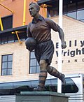
Wolverhampton Wanderers FC

ImageTitle / subjectLocation and
coordinates
DateArtist / designerTypeMaterialDimensionsDesignationOwner / administratorNotes
BillyWrightStatue.jpg
More images
Billy Wright The MolineuxWolverhampton

52°35′24″N2°07′55″W / 52.590039°N 2.131878°W / 52.590039; -2.131878
1996 (1996) James Butler Statue Bronze Wolverhampton Wanderers F.C. [18] As of mid January 2017, the plaques below the statue have been damaged due to a car crash [19]
StanCullisStatue.jpg
More images
Stan Cullis The MolineuxWolverhampton

52°35′28″N2°07′51″W / 52.59111°N 2.1308°W / 52.59111; -2.1308
2003 (2003) James Butler Statue Bronze Wolverhampton Wanderers F.C. Former player and manager of Wolverhampton Wanderers from 1934 to 1964 [20]
Statue of Sir Jack Hayward at The Molineux in Wolverhampton (47467413961).jpg
More images
Sir Jack Hayward The MolineuxWolverhampton

52°35′22″N2°07′53″W / 52.589441°N 2.131415°W / 52.589441; -2.131415
2018 (2018) James Butler Statue Bronze Wolverhampton Wanderers F.C. Was the owner of Wolves for 17 years until 2007. [21]

Other city centre areas

ImageTitle / subjectLocation and
coordinates
DateArtist / designerTypeMaterialDimensionsDesignationOwner / administratorNotes
The Wheatsheaf - Tower Street, Wolverhampton (16158236433).jpg
More images
The WheatsheafThe Wheatsheaf – Tower Street, Wolverhampton

52°35′05″N2°07′31″W / 52.584689°N 2.125276°W / 52.584689; -2.125276
 ()Sculpture
Thornley Street, Wolverhampton - Gateway East sculpture (16138514113).jpg
More images
City GatewayEither side of Stafford Street, Wolverhampton

52°35′20″N2°07′35″W / 52.589004°N 2.126327°W / 52.589004; -2.126327
2008 (2008)Julia RowleySculpture Stainless steel, glass & acrylic 5 metresGateway East near Thornley Street. Gateway West near a University of Wolverhampton building [22]
Sunbeam record attempt bronze panel.JPG Sunbeam Car PanelsSt. John's Retail Park, Wolverhampton

52°34′47″N2°07′38″W / 52.57963°N 2.12734°W / 52.57963; -2.12734 (approx)
1995 (1995) Steve Field, John McKenna Relief sculpture Bronze 3m by 2mSt John's Retail Park [23]
Wolverhampton St John's Retail Park Railings 2.JPG
More images
Historical Car and Motorcycle Company LogosRailings of St John's Retail Park, Wolverhampton

52°34′47″N2°07′34″W / 52.579655°N 2.126114°W / 52.579655; -2.126114
1995 (1995) Steve Field, John McKenna SculptureSteel, with applied surface, silver/greyFence panels: Slight variations but one is 36cm high x 62 cm wide, another is 50cm diameter. Large panel:100cm diameter approxSt John's Retail ParkLogos for Guy, The Sunbeam, Clyno etc [24]
Wolverhampton Sainsbury's Sculpture.JPG Out of the Darkness Cometh Light Sainsbury's – St Mark's Street, Wolverhampton

52°35′02″N2°08′08″W / 52.583931°N 2.135516°W / 52.583931; -2.135516
2014 (2014)Planet Art (Julie Edwards & Ron Thompson)Sculpture Stainless steel 8m Sainsbury's Stainless steel vase sculpture for the new Sainsbury's Raglan Street store [25]
Horseley Fields sculptures in Wolverhampton (51287598045).jpg Horseley Fields horsesCorner of Horseley Fields and Corn Hill, Wolverhampton

52°35′08″N2°07′12″W / 52.58557815479327°N 2.119887769172608°W / 52.58557815479327; -2.119887769172608
Horse sculpturesOn the corner of the Horseley Fields housing development

West Park

ImageTitle / subjectLocation and
coordinates
DateArtist / designerTypeMaterialDimensionsDesignationOwner / administrator Wikidata Notes
Statue of Charles Pelham Villiers at West Park, Wolverhampton (47481219521).jpg
More images
Charles Pelham Villiers West Park, Wolverhampton

52°35′23″N2°08′27″W / 52.58984°N 2.1408°W / 52.58984; -2.1408
1878 (1878) W.Theed the younger Statue Ashlar Grade II listed [26] Wolverhampton City Council Q26497586 MP for Wolverhampton for 63 years. The statue was moved from its original position in Snow Hill in 1931.
Wolverhampton West Park Victorian Sewer.JPG
More images
Victorian Sewer West Park, Wolverhampton

52°35′14″N2°08′19″W / 52.587238°N 2.138652°W / 52.587238; -2.138652
1970sSculpture Brick Wolverhampton City Council Built for a Wolverhampton Fiesta in the 1970s

Blakenhall

ImageTitle / subjectLocation and
coordinates
DateArtist / designerTypeMaterialDimensionsDesignationOwner / administratorNotes
Lone Rider - Steve Field.jpg The Lone RiderPenn Road, Blakenhall, Wolverhampton

52°34′33″N2°08′09″W / 52.575861°N 2.135798°W / 52.575861; -2.135798
1996 (1996) Steve Field SculptureHoptonwood limestone Marks the site of the former AJS motorcycle factory. Carved by Robert Bowers, assisted by Michael Scheuermann. [23] [27]

Heath Town

ImageTitle / subjectLocation and
coordinates
DateArtist / designerTypeMaterialDimensionsDesignationOwner / administratorNotes
Wolverhampton Reflective Metal Bridge.JPG Reflective Metal Bridge Wyrley and Essington CanalHeath Town, Wolverhampton

52°35′35″N2°06′05″W / 52.593075°N 2.101318°W / 52.593075; -2.101318
 ()SculptureSteel [28]

New Cross Hospital

ImageTitle / subjectLocation and
coordinates
DateArtist / designerTypeMaterialDimensionsDesignationOwner / administratorNotes
Circle of Life at New Cross Hospital (53259478233).jpg
More images
Circle of Life New Cross HospitalHeath Town, Wolverhampton

52°35′49″N2°05′48″W / 52.596936°N 2.096624°W / 52.596936; -2.096624
1998 (1998)Katie ChambersSculptureConcrete & pebbles Plinth: 57cm high x 3.5m diameter. Outer ring: 3m diameter. Inner cylinder: 60cm diameter x 32cm deep. Bed: 6.3m diameter. Wolverhampton City Council [29]
Wolverhampton New Cross Alphabet Column.JPG
More images
Lettered Column New Cross Hospital – Wolverhampton Road, Heath Town, Wolverhampton

52°35′49″N2°05′39″W / 52.596965°N 2.094213°W / 52.596965; -2.094213
2002 (2002)Meic WattsSculpture Granite blocks, steel5.2m high, with circumference of 2.8m at base Wolverhampton City Council [30]
Wolverhampton New Cross Column.JPG
More images
New Cross Column New Cross Hospital – Wolverhampton Road, Heath Town, Wolverhampton

52°35′48″N2°05′42″W / 52.596714°N 2.094863°W / 52.596714; -2.094863
2002 (2002)Sculpture Granite blocks Wolverhampton City Council

Bilston

Town Centre

ImageTitle / subjectLocation and
coordinates
DateArtist / designerTypeMaterialDimensionsDesignationOwner / administratorNotes
Bilston teails area sculpture.JPG
More images
High Street entrance markerJunction of Dudley Street and High Street, Bilston

52°33′52″N2°04′45″W / 52.564334°N 2.079195°W / 52.564334; -2.079195
1999 (1999)Kate Maddison of Chrysalis ArtsSculptureSteel, natural, gold and blue6.5m high Wolverhampton City Council The top of the spiral has two flying doves on it. [31] [32]
Bilston Retail area sculpture.JPG
More images
Church Street entrance markerJunction of Lichfield Street and Church Street, Bilston

52°33′58″N2°04′27″W / 52.566198°N 2.074051°W / 52.566198; -2.074051
2004 (2004)Kate Maddison of Chrysalis ArtsSculptureSteel7.5-metre column Wolverhampton City Council Has a gilded rising sun and a stainless steel mantle [32]
Church Street, Bilston - Women's Work (27915052339).jpg
More images
Women's WorkOutside the Horse and Jockey, Church Street, Bilston

52°33′56″N2°04′35″W / 52.565688°N 2.076406°W / 52.565688; -2.076406
May 1998 (1998-05) Rose Garrard Sculpture Bronze Wolverhampton City Council A female figure beside a pit-head gantry, commemorates the impoverished women working in the 19th century coal and iron industries of the Black Country. [33] Based on a 19th Century photograph of a pit bank wench or coal picker from Bilston [34]
Amber the Fire Breather.JPG Amber the Fire Breatherback garden of Bilston Craft Gallery and Museum – Mount Pleasant, Bilston

52°34′05″N2°04′18″W / 52.568003°N 2.071568°W / 52.568003; -2.071568
1994 (1994)Graham JonesSculpture Oak and sweet chestnut 12m long Wolverhampton City Council [35]
Job Centre Artwork.JPG
More images
Industrial Images Job Centre Plus – Junction of Smith Street and High Street, Bilston

52°33′51″N2°04′47″W / 52.564262°N 2.079809°W / 52.564262; -2.079809
1995 (1995) John McKenna Relief Brick, red and buff, partially painted3m x 2.75m Job Centre Plus [36] Brick relief panel was depicting former Bilston Industry [37]
Witness.JPG
More images
WitnessChurch Street bridge, Bilston

52°33′58″N2°04′32″W / 52.566021°N 2.075504°W / 52.566021; -2.075504
1997 (1997)Bettina FurneeSculpture Cast iron Wolverhampton City Council Text composed using tape recordings from an oral history project looking back at the local steel industry which came to an end in the 1980s. On 14 panels. [38] [39]

Black Country Route

ImageTitle / subjectLocation and
coordinates
DateArtist / designerTypeMaterialDimensionsDesignationOwner / administratorNotes
Hovering kestrel by John McKenna sculptor (2).jpg
More images
Hovering kestrelCitadel Logistics Building on the Black Country Route, Bilston

52°34′07″N2°03′18″W / 52.568519°N 2.055003°W / 52.568519; -2.055003
2009 (2009) John McKenna Sculpture Stainless steel Wolverhampton City Council [40]
Steel Columns by Robert Koenig.JPG
More images
Steel Columnsnext to footpath adjacent to Oxford Street Roundabout near Black Country Route, Bilston

52°33′54″N2°04′16″W / 52.565072°N 2.071207°W / 52.565072; -2.071207
1996 (1996) Robert Koenig Sculpture Sweet Chestnut trunks, painted black, red, and yellowFront row: 450cm high x 38cm diameter, middle row: 505cm high x 40cm diameter, back row: 560cm high x 45cm diameter Wolverhampton City Council [41]
Three Columns sculpture.JPG
More images
Steel MonolithsRoundabout between Millfields Road, High Street, Wolverhampton Street and Coseley Road near Black Country Route, Bilston

52°33′49″N2°05′00″W / 52.563571°N 2.083344°W / 52.563571; -2.083344
1996 (1996)Miles DavisSculptureCore-ten steelApproximately 10m high Wolverhampton City Council [42] Sculpture consisting of 3 steel monoliths about 10 meters high to reflect Bilston’s engineering past. [43]
Tower of light.JPG
More images
Tower of LightAdjacent to Bilston Football Club – Vulcan Roundabout – Black Country Route, Bilston

52°33′56″N2°03′55″W / 52.565571°N 2.065191°W / 52.565571; -2.065191
1998 (1998) Eilis O'Connell SculptureStainless steel, glass and fibre optics16.5m high x 2m diameter at base Wolverhampton City Council [44] [45]
Beth's Arch, Bilston, Wolverhampton - geograph.org.uk - 1801822.jpg
More images
Beth's ArchRoundabout adjacent to Bilston firestation – Black Country Route, Bilston

52°33′44″N2°04′59″W / 52.562183°N 2.082981°W / 52.562183; -2.082981
1996 (1996)Sarah TombsSculptureSteel, painted black and brown8m Wolverhampton City Council named after Elizabeth one of the Blast Furnaces located at the Steelworks that once stood nearby [46] [47]
Enshrined Pressure.JPG
More images
Black Country Route Special Features ProjectBlack Country Route, Bilston

52°33′49″N2°04′42″W / 52.563576°N 2.078437°W / 52.563576; -2.078437
1993 (1993)Richard CriddleSculptureFabricated steel, painted blue Wolverhampton City Council At least 7 sculptures along the route [48] [49] Wall relief (x4) in small gardens. [50]
Morrisons - Black Country Route, Bilston - Tower Panels (38795281835).jpg
More images
Tower PanelsMorrisons, Black Country Route, Bilston

52°33′50″N2°04′34″W / 52.563921°N 2.076137°W / 52.563921; -2.076137
1995 (1995) Steve Field Panelssheet steel against a background of plate glassFour metal panels 4m high x 3m wide Morrisons Three panels on four sides, depicting work in a rolling mill, mining and an imaginative panel
Bert Williams Leisure Centre - Black Country Route, Bilston - Fire & Water sculpture (39692960531).jpg Fire & WaterBert Williams Leisure Centre, Nettlefolds Way, Bilston

52°33′47″N2°04′39″W / 52.563001°N 2.077436°W / 52.563001; -2.077436
Circling the SquareLighting sculpturecoloured LED's, cast glass, stainless steel & photographic panels.WV ActiveIt lights up at night [51]

Spring Vale

ImageTitle / subjectLocation and
coordinates
DateArtist / designerTypeMaterialDimensionsDesignationOwner / administratorNotes
Stainless steel sculpture near Spring Vale, Wolverhampton - geograph.org.uk - 2320860.jpg Roll DownSpringvale Avenue

52°33′36″N2°05′18″W / 52.559911°N 2.088309°W / 52.559911; -2.088309
1994 (1994) Robert Erskine SculptureStainless steel10.5m highThe sculpture represents an ingot passing through a rolling mill. [52]

Wednesfield

ImageTitle / subjectLocation and
coordinates
DateArtist / designerTypeMaterialDimensionsDesignationOwner / administratorNotes
Wolverhampton Wednesfield Night Swimmer.JPG Night SwimmerWolverhampton Swimming & Fitness Centre – Planetary Road, Wednesfield

52°35′38″N2°05′33″W / 52.593889°N 2.092409°W / 52.593889; -2.092409
2008 (2008) Mark Renn & Mick ThackerSculptureSteel4000m x 7000m Wolverhampton City Council [14] [53]
Wolverhampton Wednesfield Phoenix Trees.JPG Phoenix TreesBowman's Island, at junction with Wednesfield Way – Planetary Road, Wednesfield

52°35′40″N2°05′32″W / 52.594524°N 2.092284°W / 52.594524; -2.092284
2001 (2001)Steve GeliotSculpture Oaks & cast metal, bronze colouredPoles: 5m high Wolverhampton City Council [54] [55]
Wolverhampton Wednesfield Sainsbury's W.JPG
More images
Past Present Future Sainsbury's – Kenmare Way, Wednesfield

52°35′51″N2°05′09″W / 52.597598°N 2.085724°W / 52.597598; -2.085724 approx
2013 (2013)Planet Art (Julie Edwards & Ron Thompson)Sculpture Stainless steel 2 screens – both 7m x 4m Wolverhampton City Council [25]
Wednesfield The Shoppers.JPG
More images
The ShoppersMemorial Park, Rookery Street Wednesfield

52°35′55″N2°05′09″W / 52.59854°N 2.08576°W / 52.59854; -2.08576
2015 (2015)Ron Thompson and Julie Ward of Planet Art.Sculpturecast iron and granite Wolverhampton City Council
Wednesfield The Bus Stop.JPG
More images
The Bus StopMemorial Park, Rookery Street Wednesfield

52°35′55″N2°05′04″W / 52.59863°N 2.08433°W / 52.59863; -2.08433
2015 (2015)Ron Thompson and Julie Ward of Planet Art.Sculpturecast iron and granite Wolverhampton City Council
Wolverhampton Wednesfield Mosaic.JPG Wednesfield MuralBealeys Fold, Wednesfield (off the High Street)

52°36′00″N2°04′55″W / 52.599938°N 2.081944°W / 52.599938; -2.081944 approx
1960s Mosaic mural tiles Wolverhampton City Council Mural by local school [56]
Saragarhi Memorial, Wednesfield (53259285121).jpg
More images
Saragarhi Memorial Between Rookery Street and Well Lane, Wednesfield

52°35′55″N2°05′04″W / 52.59849°N 2.08439°W / 52.59849; -2.08439
2021 (2021) Luke Perry Memorial statueBronze3m (10ft) tall Wolverhampton City Council A memorial to the Sikh Regiment was unveiled in Wednesfield, Wolverhampton, in September 2021. The 3-metre (9.8 ft) statue by artist Luke Perry commemorates the Battle of Saragarhi. [57] [58] There is a clay Maquette for the Saragarhi Monument at Wolverhampton Art Gallery.


Related Research Articles

The Public Monuments and Sculpture Association (PMSA) was an organisation established in 1991 to bring together individuals and organisations with an interest in British public sculptures and monuments, their production, preservation and history. It was wound up in the summer of 2020, although members dissatisfied with this decision established a successor organisation with similar objectives, the Public Statues and Sculpture Association, in the autumn of the same year.

<span class="mw-page-title-main">Bromley War Memorial</span> War memorial in London

The Bromley War Memorial in Bromley, Greater London, England commemorates the fallen of World War I and World War II. It was designed by British sculptor Sydney March, of the March family of artists.

The Marsh Award for Excellence in Public Sculpture is an annual award for public sculpture in the UK or Ireland.

References

  1. Historic England. "Prince Albert Statue (Grade II) (1201858)". National Heritage List for England . Retrieved 12 March 2015.
  2. "PMSA". pmsa.org.uk. Archived from the original on 2 April 2015.
  3. Historic England. "Lloyds Bank (Grade II) (1279604)". National Heritage List for England . Retrieved 25 March 2015.
  4. "PMSA". pmsa.org.uk. Archived from the original on 2 April 2015.
  5. "PMSA". pmsa.org.uk. Archived from the original on 2 April 2015.
  6. Historic England. "Harris Memorial (St Peter's Gardens) (Grade II) (1355124)". National Heritage List for England . Retrieved 12 March 2015.
  7. "PMSA". pmsa.org.uk. Archived from the original on 2 April 2015.
  8. "PMSA". pmsa.org.uk. Archived from the original on 2 April 2015.
  9. Historic England. "Art Gallery and Museum (Grade II*) (1201828)". National Heritage List for England . Retrieved 25 March 2015.
  10. "PMSA". pmsa.org.uk. Archived from the original on 24 September 2015.
  11. "PMSA". pmsa.org.uk. Archived from the original on 2 April 2015.
  12. "PMSA". pmsa.org.uk. Archived from the original on 2 April 2015.
  13. "Signal Man". Art Map Wolverhampton. Archived from the original on 2 April 2015.
  14. 1 2 "Mick Thacker". axisweb.org.
  15. "Locomotion 2". Art Map Wolverhampton. Archived from the original on 2 April 2015. Retrieved 26 March 2015.
  16. "Echelon with Concrete Pillars". Art Map Wolverhampton. Archived from the original on 17 March 2015. Retrieved 12 March 2015.
  17. "PMSA". pmsa.org.uk. Archived from the original on 24 September 2015.
  18. "Billy Wright Statue". Art Map Wolverhampton. Archived from the original on 6 May 2012.
  19. "Wolves legend Billy Wright's statue smashed in car crash". bbc.co.uk/news. Retrieved 16 January 2017.
  20. "Stan Cullis". Offbeat Group. Retrieved 26 March 2019.
  21. "Wolves unveil statue of Sir Jack Hayward". bbc.co.uk/news. Retrieved 14 June 2018.
  22. "City Gateway". Julia Rowley Glass.
  23. 1 2 Noszlopy, George Thomas; Waterhouse, Fiona (1 January 2005). Public Sculpture of Staffordshire and the Black Country. Liverpool University Press. ISBN   9780853239895.
  24. "PMSA". pmsa.org.uk. Archived from the original on 2 April 2015.
  25. 1 2 "Planet Art CV" (PDF). Planet Art Sculpture. Archived from the original (PDF) on 2 April 2015. Retrieved 25 March 2015.
  26. Historic England. "Villiers Statue (Grade II) (1201900)". National Heritage List for England . Retrieved 27 March 2019.
  27. "The Lone Rider". The Lone Rider. Public Monuments and Sculpture Association. Archived from the original on 20 October 2013. Retrieved 19 October 2013.
  28. "Reflective Metal Bridge". Art Map Wolverhampton. Archived from the original on 16 March 2015. Retrieved 25 March 2015.
  29. "PMSA". pmsa.org.uk. Archived from the original on 2 April 2015. Retrieved 26 March 2015.
  30. "PMSA". pmsa.org.uk. Archived from the original on 2 April 2015.
  31. "PMSA". pmsa.org.uk. Archived from the original on 2 April 2015.
  32. 1 2 "Banners Seats Markers – Bilston". Chrysalis Arts.[ permanent dead link ]
  33. ""Women's Work" 1996 - 1998". Rose Garrard. Retrieved 14 January 2018.
  34. "Womens Work". Art Map Wolverhampton. Archived from the original on 20 March 2015.
  35. "PMSA". pmsa.org.uk. Archived from the original on 2 April 2015.
  36. "PMSA". pmsa.org.uk. Archived from the original on 24 September 2015.
  37. "Bilston Job Centre facade". John McKenna A4A.
  38. "Witness, 1997". Bettina Furnee. Retrieved 13 January 2018.
  39. "Witness". Art Map Wolverhampton. Archived from the original on 17 March 2015.
  40. "Hovering Kestrel". John McKenna A4A.
  41. "PMSA". pmsa.org.uk. Archived from the original on 24 September 2015.
  42. "PMSA". pmsa.org.uk. Archived from the original on 2 April 2015.
  43. "Steel Monoliths". Art Map Wolverhampton. Archived from the original on 19 March 2015.
  44. "PMSA". pmsa.org.uk. Archived from the original on 2 April 2015.
  45. "Tower of Light". Art Map Wolverhampton. Archived from the original on 28 May 2014.
  46. "Beth's Arch". Art Map Wolverhampton. Archived from the original on 2 April 2015.
  47. "PMSA". pmsa.org.uk. Archived from the original on 2 April 2015.
  48. "PMSA". pmsa.org.uk. Archived from the original on 2 April 2015.
  49. "Black Country Route". Richard Criddle Sculpture. Retrieved 15 January 2018.
  50. "Special Feature Project". Art Map Wolverhampton. Archived from the original on 17 March 2015.
  51. "Lighting". Circling the Square. Retrieved 14 January 2018.
  52. "Roll Down" Art UK. Retrieved 1 December 2023.
  53. "Night Swimmer". Art Map Wolverhampton. Archived from the original on 17 March 2015. Retrieved 25 March 2015.
  54. "5 Tree-lined Avenue". Art Map Wolverhampton. Archived from the original on 2 April 2015. Retrieved 26 March 2015.
  55. "PMSA". pmsa.org.uk. Archived from the original on 2 April 2015.
  56. "Wednesfield Mural – Bealeys Fold". geograph.org.uk.
  57. "Wolverhampton Memorial to Sikh soldiers is unveiled". BBC News. 12 September 2021. Archived from the original on 12 September 2021. Retrieved 13 September 2021.
  58. "Wolverhampton memorial to Sikh soldiers set to be cast in bronze". BBC News. 11 December 2020. Archived from the original on 18 April 2021. Retrieved 13 September 2021.