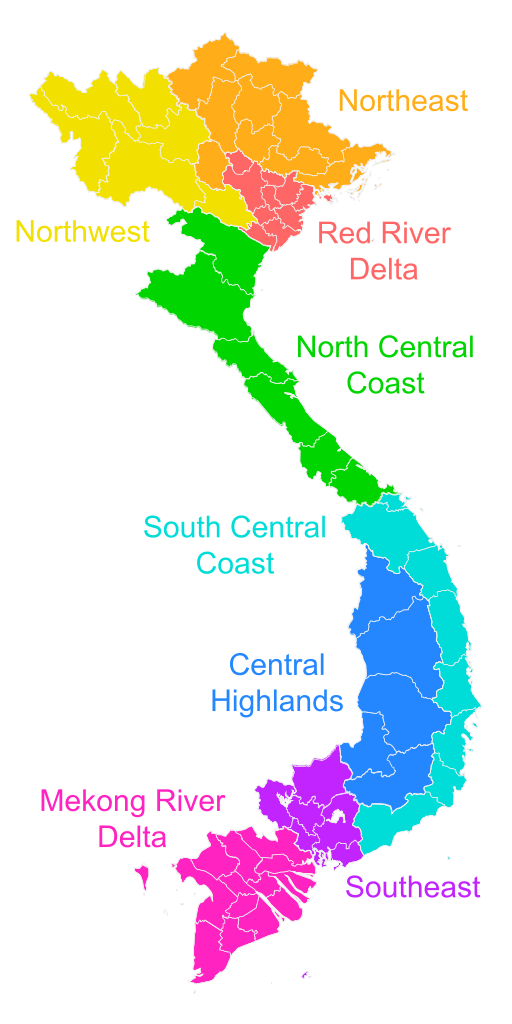
The Vietnamese government often groups the various provinces and municipalities into three regions: Northern Vietnam, Central Vietnam, and Southern Vietnam. These regions can be further subdivided into eight subregions: Northeast Vietnam, Northwest Vietnam, the Red River Delta, the North Central Coast, the South Central Coast, the Central Highlands, Southeast Vietnam, and the Mekong River Delta. These regions are not always used, and alternative classifications are possible. Other classifications used can be: Northern, Central, Southern, and Mekong.
Northern- Hanoi, Hai Phong, Hai Duong, Thai Binh, Bac Giang, Nam Dinh, Phu Tho, Bac Ninh, Quang Ninh, Thai Nguyen, Hung Yen, Son La, Vinh Phuc, Ninh Binh, Ha Giang, Hoa Binh, Ha Nam, Yen Bai, Tuyen Quang, Lang Son, Lao Cai, Dien Bien, Cao Bang, Lai Chau, Bac Kan
Central- Thanh Hoa, Nghe An, Gia Lai, Quang Nam, Binh Dinh, Ha Tinh, Quang Ngai, Da Nang, Thua Thien Hue, Quang Binh, Phu Yen, Quang Tri, Kan Tum
Southern- Ho Chi Minh City, Dong Nai, Binh Duong, Dak Lak, Lam Dong, Khanh Hoa, Binh Thuan, Tay Ninh, Ba Ria-Vung Tau, Binh Phuoc, Dak Nong, Ninh Thuan
Mekong- An Giang, Tien Giang, Kien Giang, Long An, Dong Thap, Ben Tre, Can Tho, Soc Trang, Ca Mau, Vinh Long, Tra Vinh, Bac Lieu, Hau Giang
Region | Subregion | Provinces | Area (km2) [1] [2] | Population (2022) [1] | Density (people per km2) | Notes |
---|---|---|---|---|---|---|
Northern Vietnam (Bắc Bộ, Miền Bắc) | Northeast (Đông Bắc Bộ) | 50,826.38 | 9,474,710 | 186.41 | It contains most of the mountainous provinces that lie to north of the Red River lowlands. | |
Northwest (Tây Bắc Bộ) | 50,565.71 | 4,911,370 | 97.13 | It contains inland provinces in the west of Vietnam's northern part. Two provinces border Laos, and three border China. | ||
Red River Delta (Đồng Bằng Sông Hồng) | 15,070.70 | 22,091,250 | 1,465.84 | It contains small but populous provinces in the Thái Bình river system and Red River system. The Red River Delta has the smallest area but highest population and population density of all regions. | ||
Central Vietnam (Trung Bộ, Miền Trung) | North Central Coast (Bắc Trung Bộ) | 51,242.75 | 11,190,830 | 218.39 | It contains the coastal provinces in the northern half of Vietnam's narrow central part. They all stretch from the coast in the east to Laos in the west. | |
South Central Coast (Duyên hải Nam Trung Bộ) | 44,605.12 | 9,470,840 | 212.33 | It contains the coastal provinces in the southern half of Vietnam's central part. | ||
Central Highlands (Tây Nguyên) | 54,548.31 | 6,092,420 | 111.69 | It contains mountainous inland provinces of south-central Vietnam. The region has a high concentration of ethnic minorities. | ||
Southern Vietnam (Nam Bộ, Miền Nam) | Southeast (Đông Nam Bộ, Miền Đông) | 23,551.42 | 18,810,780 | 798.71 | It contains the lowland parts of southern Vietnam north of the Mekong delta. | |
Mekong River Delta (Đồng Bằng Sông Cửu Long) or Southwest (Tây Nam Bộ, Miền Tây) | 40,922.58 | 17,432,120 | 425.98 | It is Vietnam's southernmost region, mostly containing small but populous provinces in the Mekong delta. It is sometimes referred to as the Southwest region (Tây Nam Bộ, Miền Tây). |
Name | Capital | Population (2022) [1] | Area (km2) [1] [2] |
---|---|---|---|
Northern Vietnam (Bắc Bộ) | |||
Northeast Vietnam (Đông Bắc Bộ) | |||
Bắc Giang | Bắc Giang | 1,890,930 | 3,895.89 |
Bắc Kạn | Bắc Kạn | 324,350 | 4,859.96 |
Cao Bằng | Cao Bằng | 543,050 | 6,700.39 |
Hà Giang | Hà Giang | 892,720 | 7,927.55 |
Lạng Sơn | Lạng Sơn | 802,090 | 8,310.18 |
Phú Thọ | Việt Trì | 1,516,920 | 3,534.56 |
Quảng Ninh | Hạ Long | 1,362,880 | 6,207.93 |
Thái Nguyên | Thái Nguyên | 1,335,990 | 3,521.97 |
Tuyên Quang | Tuyên Quang | 805,780 | 5,867.95 |
Northwest Vietnam (Tây Bắc Bộ) | |||
Điện Biên | Điện Biên Phủ | 635,920 | 9,539.93 |
Hòa Bình | Hòa Bình | 875,380 | 4,590.30 |
Lai Châu | Lai Châu | 482,100 | 9,068.73 |
Lào Cai | Lào Cai | 770,590 | 6,364.25 |
Sơn La | Sơn La | 1,300,130 | 14,109.83 |
Yên Bái | Yên Bái | 847,250 | 6,892.67 |
Red River Delta (Đồng bằng sông Hồng) | |||
Bắc Ninh | Bắc Ninh | 1,488,200 | 822.71 |
Hà Nam | Phủ Lý | 878,000 | 861.93 |
Hải Dương | Hải Dương | 1,946,820 | 1,668.28 |
Hưng Yên | Hưng Yên | 1,290,850 | 930.20 |
Nam Định | Nam Định | 1,876,850 | 1,668.83 |
Ninh Bình | Ninh Bình | 1,010,700 | 1,411.78 |
Thái Bình | Thái Bình | 1,878,540 | 1,584.61 |
Vĩnh Phúc | Vĩnh Yên | 1,197,620 | 1,236.00 |
Hà Nội (municipality) | 8,435,650 | 3,359.84 | |
Hải Phòng (municipality) | 2,088,020 | 1,526.52 | |
Central Vietnam (Trung Bộ) | |||
North Central Coastal Vietnam (Bắc Trung Bộ) | |||
Hà Tĩnh | Hà Tĩnh | 1,323,750 | 5,994.45 |
Nghệ An | Vinh | 3,419,990 | 16,486.49 |
Quảng Bình | Đồng Hới | 913,860 | 7,998.76 |
Quảng Trị | Đông Hà | 650,950 | 4,701.23 |
Thanh Hóa | Thanh Hóa | 3,722,060 | 11,114.71 |
Thừa Thiên Huế | Huế | 1,160,220 | 4,947.11 |
South Central Coastal Vietnam (Duyên hải Nam Trung Bộ) | |||
Bình Định | Qui Nhơn | 1,504,290 | 6,066.40 |
Bình Thuận | Phan Thiết | 1,252,060 | 7,942.60 |
Khánh Hòa | Nha Trang | 1,253,970 | 5,199.62 |
Ninh Thuận | Phan Rang–Tháp Chàm | 598,680 | 3,355.70 |
Phú Yên | Tuy Hòa | 876,620 | 5,025.96 |
Quảng Nam | Tam Kỳ | 1,519,380 | 10,574.86 |
Quảng Ngãi | Quảng Ngãi | 1,245,650 | 5,155.25 |
Đà Nẵng (municipality) | 1,220,190 | 1,284.73 | |
Central Highlands (Tây Nguyên) | |||
Đắk Lắk | Buôn Ma Thuột | 1,918,440 | 13,070.41 |
Đắk Nông | Gia Nghĩa | 670,560 | 6,509.27 |
Gia Lai | Pleiku | 1,590,980 | 15,510.13 |
Kon Tum | Kon Tum | 579,910 | 9,677.30 |
Lâm Đồng | Da Lat | 1,332,530 | 9,781.20 |
Southern Vietnam (Nam Bộ) | |||
Southeast Vietnam (Đông Nam Bộ) | |||
Bà Rịa–Vũng Tàu | Vũng Tàu | 1,178,700 | 1,982.56 |
Bình Dương | Thủ Dầu Một | 2,763,120 | 2,694.64 |
Bình Phước | Đồng Xoài | 1,034,670 | 6,873.56 |
Đồng Nai | Biên Hòa | 3,255,810 | 5,863.62 |
Tây Ninh | Tây Ninh | 1,188,760 | 4,041.65 |
Hồ Chí Minh City (municipality) | 9,389,720 | 2,095.39 | |
Mekong River Delta (Đồng bằng sông Cửu Long)1 | |||
An Giang | Long Xuyên | 1,905,520 | 3,536.82 |
Bạc Liêu | Bạc Liêu | 921,810 | 2,667.88 |
Bến Tre | Bến Tre | 1,298,010 | 2,379.70 |
Cà Mau | Cà Mau | 1,207,630 | 5,274.51 |
Đồng Tháp | Cao Lãnh | 1,600,170 | 3,382.28 |
Hậu Giang | Vị Thanh | 729,470 | 1,622.23 |
Kiên Giang | Rạch Giá | 1,751,760 | 6,352.92 |
Long An | Tân An | 1,734,260 | 4,494.78 |
Sóc Trăng | Sóc Trăng | 1,197,820 | 3,298.20 |
Tiền Giang | Mỹ Tho | 1,785,240 | 2,556.36 |
Trà Vinh | Trà Vinh | 1,019,260 | 2,390.77 |
Vĩnh Long | Vĩnh Long | 1,028,820 | 1,525.73 |
Cần Thơ (municipality) | 1,252,350 | 1,440.40 |
1 – a.k.a. Southwest Vietnam (Tây Nam Bộ)
Vietnam is divided into 63 first-level subdivisions, comprising fifty-eight provinces and five municipalities under the command of the central government. Municipalities are the highest-ranked cities in Vietnam. Municipalities are centrally-controlled cities and have special status equal to that of the provinces.
Articles related to Vietnam and Vietnamese culture include:
Hải Dương is a city in Vietnam. It is the capital of Hải Dương, an industrialized province in the Hanoi Capital Region and the Red River Delta in Northern Vietnam. The city is at the midpoint between the capital Hanoi and the major port Haiphong, and is part of the Northern Key Economic Zone. In 2019, Hai Duong city had a population of 241,373.
Lệ Thủy is a district of Quảng Bình province in the North Central Coast of Vietnam. The district borders Quảng Ninh district on the north, Vĩnh Linh district on the south, Laos on the west. Lệ Thủy central is 40 km south of the provincial capital Đồng Hới. The district government seat is Kiến Giang Township. The district area is 1420.52 km2, population: 140,804 (1998). Lệ Thủy district is home to Võ Nguyên Giáp and the family of Ngô Đình Diệm. Economy bases on agriculture, mainly rice culture. Mỹ Trạch massacre by French army happened here on 29 November 1947.
National Route 1, also known as National Route 1A, is the trans-Vietnam highway. The route begins at km 0 at Hữu Nghị Quan Border Gate near the China-Vietnam border, runs the length of the country connecting major cities including Hanoi, Da Nang and Ho Chi Minh City, and ends at km 2301.34 at Năm Căn township in Cà Mau province.
Tân Bình may refer to several places in Vietnam, including:
Vietnam's country code is +84. There are many area codes for landlines, as well as a separate format for mobile phone numbers. The five emergency phone numbers are 111, 112, 113 (police), 114 (fire), and 115.
The Anarchy of the 12 Warlords, also the Period of the 12 Warlords, was a period of chaos and civil war in the history of Vietnam, from 965 to 968 caused by the succession of the Ngô dynasty after the death of King Ngô Quyền. This period is also sometimes simply called the Twelve Warlords. Four of the warlords are verified to have traced their direct lineage from what is now China today. This period ended in 968 with the unification war of Vietnam by Đinh Bộ Lĩnh, who later established the Đinh dynasty.
Tan Thanh may refer to several populated places in Vietnam:
Hanoi Capital Region or Hanoi Metropolitan Area is a metropolitan area currently planned by the government of Vietnam. This metropolitan area was created by decision 490/QD-TTg dated May 5, 2008 of the Prime Minister of Vietnam. Hanoi will be the core city of this metropolitan area. Other component parts will include provinces: Vĩnh Phúc Province, Hưng Yên Province, Bắc Ninh Province, Hải Dương Province, Hà Nam Province, Hòa Bình, Bắc Giang Province, Phú Thọ Province and Thái Nguyên Province with an area of 24,314.7 km², half of the size of Greater Ho Chi Minh City, the same for population size planning.
Đào Xá, is a very common name of many villages in rural northern Vietnam. Many villages are named Dao Xa village traditional identity or the historical cultural attractions.
The North–South Expressway East is an expressway in Vietnam located very close to National Route 1, acting as an artery traversing the entirety of Vietnam from North to South. Similar to National Route 1, the expressway starts from Lạng Sơn and ends at Cà Mau. At the northern border, the expressway will connect to Nanning-Youyiguan Expressway in China.
The Six Provinces of Southern Vietnam is a historical name for the region of Southern Vietnam, which is referred to in French as Basse-Cochinchine. The region was politically defined and established after the inauguration of the Nguyễn dynasty, and called by this name from 1832, when Emperor Minh Mạng introduced administrative reforms, to 1867, which culminated in the eight-year French campaign to conquer the Six Provinces.
Flags of the Nguyễn dynasty's administrative units were used since about 1868 to 1885, with 1:1 ratio.