A request that this article title be changed to List of reservoirs in the United Kingdom is under discussion. Please do not move this article until the discussion is closed. |
The following page lists the largest reservoirs in the United Kingdom.
A request that this article title be changed to List of reservoirs in the United Kingdom is under discussion. Please do not move this article until the discussion is closed. |
The following page lists the largest reservoirs in the United Kingdom.
Lake Kickapoo is a reservoir located on the North Fork Little Wichita River in the Red River Basin of Archer County, Texas. It is neighbored by Archer City, Texas and Wichita Falls, Texas which reside within the Central Great Plains ecoregion.

Wetlands, or simply a wetland, is a distinct ecosystem that is flooded or saturated by water, either permanently or seasonally. Flooding results in oxygen-free (anoxic) processes prevailing, especially in the soils. The primary factor that distinguishes wetlands from terrestrial land forms or water bodies is the characteristic vegetation of aquatic plants, adapted to the unique anoxic hydric soils. Wetlands are considered among the most biologically diverse of all ecosystems, serving as home to a wide range of plant and animal species. Methods for assessing wetland functions, wetland ecological health, and general wetland condition have been developed for many regions of the world. These methods have contributed to wetland conservation partly by raising public awareness of the functions some wetlands provide.
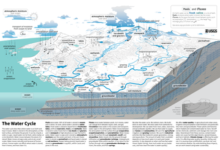
The water cycle, also known as the hydrologic cycle or the hydrological cycle, is a biogeochemical cycle that describes the continuous movement of water on, above and below the surface of the Earth. The mass of water on Earth remains fairly constant over time but the partitioning of the water into the major reservoirs of ice, fresh water, saline water and atmospheric water is variable depending on a wide range of climatic variables. The water moves from one reservoir to another, such as from river to ocean, or from the ocean to the atmosphere, by the physical processes of evaporation, transpiration, condensation, precipitation, infiltration, surface runoff, and subsurface flow. In doing so, the water goes through different forms: liquid, solid (ice) and vapor. The ocean plays a key role in the water cycle as it is the source of 86% of global evaporation.

Groundwater is the water present beneath Earth's surface in rock and soil pore spaces and in the fractures of rock formations. About 30 percent of all readily available freshwater in the world is groundwater. A unit of rock or an unconsolidated deposit is called an aquifer when it can yield a usable quantity of water. The depth at which soil pore spaces or fractures and voids in rock become completely saturated with water is called the water table. Groundwater is recharged from the surface; it may discharge from the surface naturally at springs and seeps, and can form oases or wetlands. Groundwater is also often withdrawn for agricultural, municipal, and industrial use by constructing and operating extraction wells. The study of the distribution and movement of groundwater is hydrogeology, also called groundwater hydrology.
Induced seismicity is typically earthquakes and tremors that are caused by human activity that alters the stresses and strains on Earth's crust. Most induced seismicity is of a low magnitude. A few sites regularly have larger quakes, such as The Geysers geothermal plant in California which averaged two M4 events and 15 M3 events every year from 2004 to 2009. The Human-Induced Earthquake Database (HiQuake) documents all reported cases of induced seismicity proposed on scientific grounds and is the most complete compilation of its kind.

Grid energy storage is a collection of methods used for energy storage on a large scale within an electrical power grid. Electrical energy is stored during times when electricity is plentiful and inexpensive or when demand is low, and later returned to the grid when demand is high, and electricity prices tend to be higher.

The Dowleswaram Barrage Or Dhavaleshwaram Barrage was an irrigation structure originally built in 1852 on the lower stretch of the Godavari River before it empties into the Bay of Bengal. It was rebuilt in 1970 when it was officially renamed as Sir Arthur Cotton Barrage or Godavari Barrage.

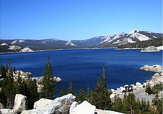
A reservoir is an enlarged lake behind a dam. Such a dam may be either artificial, built to store fresh water or it may be a natural formation.

The San Luis Reservoir is an artificial lake on San Luis Creek in the eastern slopes of the Diablo Range of Merced County, California, approximately 12 mi (19 km) west of Los Banos on State Route 152, which crosses Pacheco Pass and runs along its north shore. It is the fifth largest reservoir in California. The reservoir stores water taken from the San Joaquin-Sacramento River Delta. Water is pumped uphill into the reservoir from the O'Neill Forebay which is fed by the California Aqueduct and is released back into the forebay to continue downstream along the aqueduct as needed for farm irrigation and other uses. Depending on water levels, the reservoir is approximately nine miles (14 km) long from north to south at its longest point, and five miles (8 km) wide. At the eastern end of the reservoir is the San Luis Dam, the fourth largest embankment dam in the United States, which allows for a total capacity of 2,041,000 acre-feet (2,518,000 dam3). Pacheco State Park lies along its western shores.

Carbon capture and storage (CCS) is a process in which a relatively pure stream of carbon dioxide (CO2) from industrial sources is separated, treated and transported to a long-term storage location. For example, the carbon dioxide stream that is to be captured can result from burning fossil fuels or biomass. Usually the CO2 is captured from large point sources, such as a chemical plant or biomass plant, and then stored in an underground geological formation. The aim is to reduce greenhouse gas emissions and thus mitigate climate change.
Courtright Reservoir is a reservoir in Fresno County, California. The reservoir is at an elevation of 8,170 feet in the Sierra National Forest, in the Sierra Nevada Mountain Range, bordering the John Muir Wilderness and the Dinkey Lakes Wilderness.

Blue Mesa Reservoir is an artificial reservoir located on the upper reaches of the Gunnison River in Gunnison County, Colorado. The largest lake located entirely within the state, Blue Mesa Reservoir was created by the construction of Blue Mesa Dam, a 390-foot tall earthen fill dam constructed on the Gunnison by the U.S. Bureau of Reclamation in 1966 for the generation of hydroelectric power. Managed as part of the Curecanti National Recreation Area, a unit of the National Park Service, Blue Mesa Reservoir is the largest lake trout and Kokanee salmon fishery in Colorado.

Banasura Sagar Dam, which impounds the Karamanathodu tributary of the Kabini River, is part of the Indian Banasurasagar Project consisting of a dam and a canal project started in 1979. The goal of the project is to support the Kakkayam Hydro electric power project and satisfy the demand for irrigation and drinking water in a region known to have water shortages in seasonal dry periods. The dam is also known as Kuttiyadi Augmentation Main Earthen Dam. The dam has a height of 38.5 metres (126 ft) and length of 685 metres (2,247 ft).

The Thomson Dam is a major Clay core and rockfill embankment dam with a Uncontrolled, Ogee-shaped overflow weir and chute spillway across the Thomson River, located about 130 kilometres (81 mi) east of Melbourne in the West Gippsland region of the Australian state of Victoria. The reservoir created by the dam is officially called Thomson Reservoir, sometimes called Lake Thomson.

The Upper Yarra Reservoir is located east of Melbourne, Victoria, Australia, beyond Warburton within the locality of Reefton. Water from Upper Yarra Reservoir supplies towns in the upper Yarra Valley, and Silvan Reservoir, which transfers water to most parts of Melbourne.

The Knight Reservoir is a large pumped storage reservoir located in the Borough of Elmbridge in Surrey. It was inaugurated in 1907 and stores up to 2,180 million litres of raw water abstracted from the River Thames prior to its treatment and supply to London and north Surrey. It is located south of the River Thames, west of West Molesey, and between Hurst Road (A3050) and Walton Road (B369). It is adjacent to, and west of, its twin Bessborough Reservoir.
The Queen Elizabeth II Reservoir lies to the south of the River Thames and to the west of the Island Barn Reservoir. To the north are the Bessborough and Knight reservoirs. The A3050 runs to the north of the reservoir and it is situated in Walton on Thames. It is managed by Thames Water.

A hydrologic model is a simplification of a real-world system that aids in understanding, predicting, and managing water resources. Both the flow and quality of water are commonly studied using hydrologic models.
The global freshwater model WaterGAP calculates flows and storages of water on all continents of the globe, taking into account the human influence on the natural freshwater system by water abstractions and dams. It supports understanding the freshwater situation across the world's river basins during the 20th and the 21st centuries, and is applied to assess water scarcity, droughts and floods and to quantify the impact of human actions on e.g. groundwater, wetlands, streamflow and sea-level rise. Modelling results of WaterGAP have contributed to international assessment of the global environmental situation including the UN World Water Development Reports, the Millennium Ecosystem Assessment, the UN Global Environmental Outlooks as well as to reports of the Intergovernmental Panel on Climate Change. WaterGAP contributes to the Intersectoral Impact Model Intercomparison Project ISIMIP, where consistent ensembles of model runs by a number of global hydrological models are generated to assess the impact of climate change and other anthropogenic stressors on freshwater resources world-wide.
Water supply and sanitation in England is owned by private companies since 1989 with resources managed by the Environment Agency.