List of road routes in the Australian Capital Territory

Last updated

Road routes in the Australian Capital Territory assist drivers navigating roads throughout the territory, or may have a second local name in addition to a primary name. The ACT previously used an older, numerical shield-based system, which was replaced by a newer, alphanumeric system in 2013. Many major roads in the ACT are not assigned a route number.

Contents

The ACT implemented the federally-issued National Routes system between 1955 and 1956, using white-and-black shields highlighting interstate links between major regional centres; some of these routes were later upgraded into National Highways using green-and-gold shields when the National Roads Act was passed in 1974. Seven Tourist routes were also allocated across the territory in early 1990, but were decommissioned by 2019. [1] The alphanumeric system, introduced in 2013 (at the same time as New South Wales), has effectively replaced the previous scheme across the territory.

Roads are described in either a west–east or north–south alignment.

Current routes

ACT routes location map - current.png
Current road routes in the ACT. [2]
Legend:
  Routes
  Urbanised Land
  Water
  Native Vegetation
  Plantation

Alphanumeric routes

The alphanumeric system, introduced in 2013 (at the same time as New South Wales switched to their own alphanumeric system, as they shared some route allocations), replaced the previous National Route and National Highway scheme across the territory. It consists of alphanumeric routes, a two-digit number prefixed with a letter (M, A, or B) that denotes the grade and importance of the road, displayed on signs as yellow text on a green background with a white border; the ACT is now the only jurisdiction in Australia to use a border around allocations (NSW, previously the only other state that used them, removed them in 2020).

RouteComponent roadsFromViaToLengthNotes
New South Wales alphanumeric route M23.svg
M23
ACT/NSW border Fyshwick 15.5 km (10 mi)- allocated when Majura Parkway opened in 2016
- continues east along Federal Highway into NSW as AUS Alphanumeric Route M23.svg
- continues south along Monaro Highway as New South Wales alphanumeric route A23.svg
New South Wales alphanumeric route A23.svg
A23
Majura ACT/NSW border50 km (31 mi)- continues east along Federal Highway as New South Wales alphanumeric route M23.svg
- continues south along Monaro Highway into NSW as AUS Alphanumeric Route B23.svg
New South Wales alphanumeric route A25.svg
A25
Barton Highway ACT/NSW border Lyneham 11.9 km (7 mi)Continues north along Barton Highway into NSW as AUS Alphanumeric Route A25.svg
New South Wales alphanumeric route B52.svg
B52
Symonston Jerrabomberra ACT/NSW border4.6 km (3 mi)Continues east as AUS Alphanumeric Route B52.svg along Canberra Avenue into NSW via Queanbeyan, and back into ACT eventually via Kowen
Kings Highway ACT/NSW border Kowen ACT/NSW border7.5 km (5 mi)- continues west as AUS Alphanumeric Route B52.svg along Kings Highway into NSW via Queanbeyan, and back into ACT eventually to Fyshwick
- continues east as AUS Alphanumeric Route B52.svg along Kings Highway into NSW eventually to Batemans Bay

Former routes

ACT routes location map - former.png
Former road routes in the ACT. [3]
Legend:
  Routes
  Urbanised Land
  Water
  Native Vegetation
  Plantation

National Routes

National Routes were the first type of route numbering to be attempted in Australia on a large scale, signed with a white shield and black writing (similar in shape to the shield that appears on the Australian coat of arms), with the ACT receiving routes in 1955 to 1956. They highlighted the interstate links connecting major population, industrial and principal regions of Victoria to the rest of the Australia, in a way that was readily identifiable to interstate travellers. The system was prepared by COSRA (Conference of State Road Authorities), held between 1953 and 1954: once each state road authority agreed to the scheme, it was rolled out federally. Selected routes were later upgraded into National Highways when the National Roads Act was passed in 1974.

The ACT's National Routes were eventually replaced with the alphanumeric system in 2013: each route was converted to an alphanumeric route number, rendering the black-and-white shield redundant, with each National Route keeping their number during the conversion.

RouteComponent roadsFromViaToLengthNotes
Australian national route 23.svg
National Route 23
Federal Highway ACT/NSW borderACT/NSW border52 km (32 mi)Replaced by Australian national highway ACT 23.svg in 1974
Replaced by New South Wales alphanumeric route A23.svg in 2013
Australian national route ALT23.svg
Alternate
National Route 23
Majura Pialligo Fyshwick 15.1 km (9 mi)Allocated when Monaro Highway extension (then known as Eastern Parkway) to Pialligo completed in 1991, replaced by New South Wales alphanumeric route M23.svg when Majura Parkway opened in 2016
Australian national route 25.svg
National Route 25
Barton Highway ACT/NSW border Lyneham 11.9 km (7 mi)Allocated after road sealing and upgrades in 1956, replaced by Australian national highway ACT 25.svg in 1974
Australian national route 52.svg
National Route 52
Canberra Avenue Fyshwick Jerrabomberra ACT/NSW border4.6 km (3 mi)- re-aligned through Queanbeyan from Norse Road (and Uriarra Road and Crawford Street in NSW) to current alignment (eliminating level crossing with Bombala railway line) in 1982
- replaced by New South Wales alphanumeric route B52.svg in 2013
Kings Highway ACT/NSW border Kowen ACT/NSW border7.5 km (5 mi)Replaced by New South Wales alphanumeric route B52.svg in 2013
  Decommissioned or unsigned allocation

National Highways

With the passing of the National Roads Act in 1974, selected National Routes were further upgraded to the status of a National Highway: interstate roads linking Australia's capital cities and major regional centres that received federal funding, and were of higher importance than other National Routes. These new routes were symbolised by green shields with gold writing (the word "National" along the top of the shield, present in other states' National Highways, was excluded for those within the ACT). Both of the ACT's National Highways - connecting the territory to the Hume Highway, itself later made a National Highway in 1979 - were converted in 1974.

Like National Routes, the ACT's National Highways were also replaced with the alphanumeric system in 2013, both keeping their number during the conversion.

RouteComponent roadsFromViaToLengthNotes
Australian national highway ACT 23.svg
National Highway 23
Federal Highway ACT/NSW border Majura Lyneham 7.1 km (4 mi)Replaced by New South Wales alphanumeric route A23.svg in 2013, later by New South Wales alphanumeric route M23.svg (from ACT/NSW border to Majura) when Majura Parkway opened in 2016
Australian national highway ACT 25.svg
National Highway 25
Barton Highway ACT/NSW border Lyneham 11.9 km (7 mi)- re-aligned through Hall when Hall bypass opened in 1980
- replaced by New South Wales alphanumeric route A25.svg in 2013
  Decommissioned or unsigned allocation

Tourist routes

Canberra had a collection of Tourist Routes, but in 2015, all but Tourist Route 5 were decommissioned, with Route 5 following the next year in 2016; route markers will be progressively removed once their signs require replacement.

RouteComponent roads [4] FromViaToLengthNotes
Australian Capital Territory Tourist Drive 1.svg
Tourist Drive 1
Capital Hill Capital Hill 9 km (6 mi)Parliamentary Triangle Loop, listed clockwise from Capital Hill
Australian Capital Territory Tourist Drive 2.svg
Tourist Drive 2
City Hill City Hill 18 km (11 mi)Lake Burley Griffin Tour, listed clockwise from City Hill
Australian Capital Territory Tourist Drive 3.svg
Tourist Drive 3
Campbell Campbell 10 km (6 mi)ANZAC Memorial Loop, listed clockwise from the Australian War Memorial
Australian Capital Territory Tourist Drive 4.svg
Tourist Drive 4
City Hill City Hill 36 km (22 mi)Northern Sports and Recreation Tour, listed clockwise from City Hill
Australian Capital Territory Tourist Drive 5.svg
Tourist Drive 5
Capital Hill Capital Hill 83 km (52 mi)Science and Nature Loop, listed clockwise from Capital Hill
Australian Capital Territory Tourist Drive 6.svg
Tourist Drive 6
  • State Circle
  • Brisbane Avenue
  • National Circuit
  • Canberra Avenue
  • Dominion Circuit
  • Melbourne Avenue
  • Stonehaven Crescent
  • Hopetoun Circuit
  • Schlich Street
  • Empire Circuit
  • Akarna Street
  • Moonah Place
  • Perth Avenue
  • Darwin Avenue
  • Forster Crescent
  • Coronation Drive
  • Commonwealth Avenue
Capital Hill Capital Hill 10 km (6 mi)Embassies Tour, listed clockwise from Capital Hill
Australian Capital Territory Tourist Drive 7.svg
Tourist Drive 7
City Hill City Hill 11 km (7 mi)Museum and Education Loop, listed clockwise from City Hill
  Decommissioned or unsigned allocation

See also

Related Research Articles

<span class="mw-page-title-main">National Highway (Australia)</span> Highway system in Australia

The National Highway is a system of roads connecting all mainland states and territories of Australia, and is the major network of highways and motorways connecting Australia's capital cities and major regional centres.

<span class="mw-page-title-main">Highways in Australia</span>

Highways in Australia are generally high capacity roads managed by state and territory government agencies, though Australia's federal government contributes funding for important links between capital cities and major regional centres. Prior to European settlement, the earliest needs for trade and travel were met by narrow bush tracks, used by tribes of Indigenous Australians. The formal construction of roads began in 1788, after the founding of the colony of New South Wales, and a network of three major roads across the colony emerged by the 1820s. Similar road networks were established in the other colonies of Australia. Road construction programs in the early 19th century were generally underfunded, as they were dependent on government budgets, loans, and tolls; while there was a huge increase in road usage, due to the Australian gold rushes. Local government authorities, often known as Road Boards, were therefore established to be primarily responsible for funding and undertaking road construction and maintenance. The early 1900s saw both the increasingly widespread use of motorised transportation, and the creation of state road authorities in each state, between 1913 and 1926. These authorities managed each state's road network, with the main arterial roads controlled and maintained by the state, and other roads remaining the responsibility of local governments. The federal government became involved in road funding in the 1920s, distributing funding to the states. The depression of the 1930s slowed the funding and development of the major road network until the onset on World War II. Supply roads leading to the north of the country were considered vital, resulting in the construction of Barkly, Stuart, and Eyre Highways.

<span class="mw-page-title-main">Highway 1 (Australia)</span> Network of highways that circumnavigate Australia

Australia's Highway 1 is a network of highways that circumnavigate the country, joining all mainland capital cities except the national capital of Canberra. At a total length of approximately 14,500 km (9,000 mi) it is the longest national highway in the world, surpassing the Trans-Siberian Highway and the Trans-Canada Highway. Over a million people traverse some part of the highway network every day.

<span class="mw-page-title-main">New England Highway</span> Highway in New South Wales and Queensland

New England Highway is an 883-kilometre (549 mi) long highway in Australia running from Yarraman, north of Toowoomba, Queensland at its northern end to Hexham at Newcastle, New South Wales at its southern end. It is part of Australia's National Highway system, and forms part of the inland route between Brisbane and Sydney.

<span class="mw-page-title-main">Sturt Highway</span> Australian national highway

Sturt Highway is an Australian national highway in New South Wales, Victoria, and South Australia. It is an important road link for the transport of passengers and freight between Sydney and Adelaide and the regions along the route.

<span class="mw-page-title-main">Federal Highway (Australia)</span> Highway in New South Wales and the Australian Capital Territory

Federal Highway is a highway in New South Wales and the Australian Capital Territory. It is a part of a motorway-standard link between Sydney and Canberra, and is also the main thoroughfare between those cities.

<span class="mw-page-title-main">Barton Highway</span> Highway in New South Wales and the Australian Capital Territory

Barton Highway is a highway in New South Wales and the Australian Capital Territory. It connects Canberra to Hume Highway at Yass, and it is part of the route from Melbourne to Canberra. It is named in honour of Sir Edmund Barton, the first Prime Minister of Australia.

<span class="mw-page-title-main">Snowy Mountains Highway</span> State highway in New South Wales, Australia

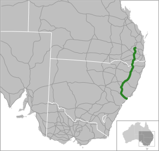
Snowy Mountains Highway is a 333-kilometre-long (207 mi) state highway located in New South Wales, Australia. Its two sections connect the New South Wales South Coast to the Monaro region, and the Monaro to the South West Slopes via the Snowy Mountains. The higher altitude regions of this road are subject to snow over the winter months, and the road also provides access to many parts of the Snowy Mountains Scheme. The highway bears the B72 shield along its entire length.

<span class="mw-page-title-main">Kings Highway (Australia)</span> Highway in the Australian Capital Territory and New South Wales

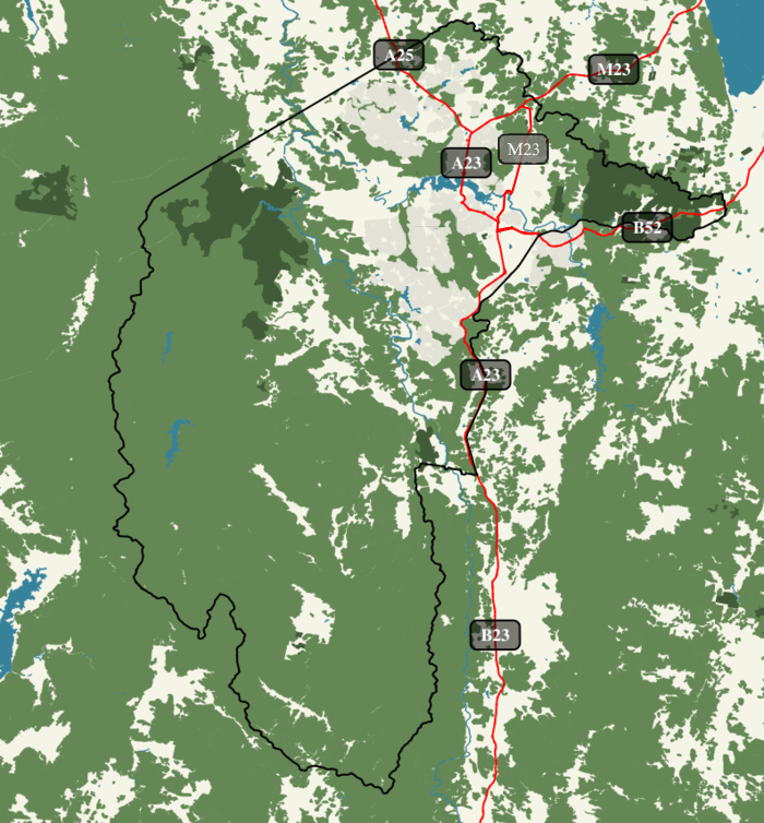
Kings Highway is an interstate highway located within the Australian Capital Territory and New South Wales, Australia. The highway connects Canberra with Batemans Bay on the South Coast. It is designated route B52.

A routenumber, designation or abbreviation is an identifying numeric designation assigned by a highway authority to a particular stretch of roadway to distinguish it from other routes and, in many cases, also to indicate its classification, general geographical location and/or orientation. The numbers chosen may be used solely for internal administrative purposes; however, in most cases they are also displayed on roadside signage and indicated on maps.

<span class="mw-page-title-main">Carnarvon Highway</span>

Carnarvon Highway is a state highway in Queensland and New South Wales, Australia, linking the township of Rolleston in Queensland's Central Highlands Region, via the town of St George, eventually to Moree in northern New South Wales. It is the main access road to the Carnarvon National Park, and serves as a strategic route to take B-doubles and other large vehicles to the Queensland ports north of Rockhampton.

<span class="mw-page-title-main">Highway shield</span> Sign denoting the route number of a highway

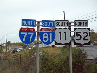
A highway shield or route marker is a sign denoting the route number of a highway, usually in the form of a symbolic shape with the route number enclosed. As the focus of the sign, the route number is usually the sign's largest element, with other items on the sign rendered in smaller sizes or contrasting colors. Highway shields are used by travellers, commuters, and all levels of government for identifying, navigating, and organising routes within a county, state, province, or country. Simplified highway shields often appear on maps.

References

  1. "Guide Signs MIS 12" (PDF). ACT Government. April 2019. p. 35. Retrieved 31 May 2021.
  2. "Guide Signs MIS 12" (PDF). ACT Government. April 2019. p. 13. Retrieved 9 June 2020.
  3. "Trunk Road Infrastructure Standard No .03 – Traffic Management" (PDF). Attachment A – Road Signs. Territory and Municipal Services. October 2012. pp. 7, 18, 24–25. Retrieved 5 October 2013.
  4. "Home". expressway.online.