This is a list of statutory listed pubs in Birmingham , West Midlands, England. [1]
| Grade | Criteria [2] |
|---|---|
| I | Buildings of exceptional interest. |
| II* | Particularly important buildings of more than special interest. |
| II | Buildings of national importance and special interest. |
| Name | Location | Date | Grid ref. Geo-coordinates | Image | Grade | Entry number |
|---|---|---|---|---|---|---|
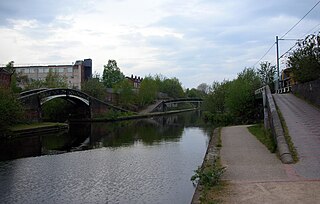
| The Anchor | Bradford St, Digbeth, B5 | 1901 | 52°28′28.24″N1°53′18.92″W / 52.4745111°N 1.8885889°W |  | II | 1234167 [3] |
| The Bartons Arms | High St, Aston, B6 | 1901 | 52°29′57″N1°53′43″W / 52.4992°N 1.8953°W |  | II* | 1076341 [4] |
| The Bell | Old Church Rd, Harborne, B17 | c. 1700 – c. 1800 | 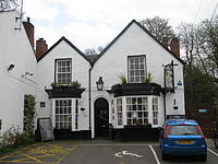 | II | 1343091 [5] | |
| Black Horse | Bristol Road South, Northfield, B31 | 1929–30 | 52°24′42″N1°58′26″W / 52.411788°N 1.973787°W | 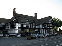 | II* | 1343340 [6] |
| Brasshouse | Broad St, City Centre, B1 | 1781 |  | II | 1075732 [7] | |
| Britannia | Lichfield Rd, Aston, B6 | 1898–1900 | 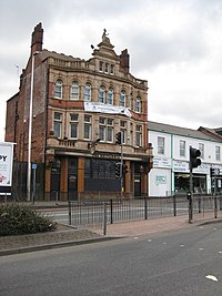 | II | 1234168 [8] | |
| British Oak | Pershore Rd, Stirchley, B30 | 1923-4 |  | II | 1257988 [9] | |
| Brookhill Tavern | Alum Rock Rd, Alum Rock, B8 | 1927–28 |  | II | 1423497 [10] | |
| The Bull | Price St, Gun Quarter, B4 | c. 1775 – c. 1800 | 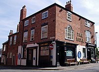 | II | 1291450 [11] | |
| The Bulls Head (formerly City Tavern) | Bishopgate St, Ladywood, B15 | 1901 |  | II | 1376199 [12] | |
| Clements Arms | Upper Trinity St, Bordesley, B10 | c. 1800 |  | II | 1276195 [13] | |
| Cosy Club (former Midland Bank) | Bennett's Hill, City Centre, B2 | 1830 |  | II | 1075753 [14] | |
| Eagle and Ball (formerly Moby Dicks) | Penn St, Nechells, B4 | c. 1840 – c. 1850 |  | II | 1076223 [15] | |
| Erdington Conservative Club | Orphanage Rd, Erdington, B24 | c. 1700 |  | II | 1076216 [16] | |
| The Fighting Cocks | St Mary's Row, Moseley, B13 | 1903 |  | II | 1220812 [17] | |
| Fox and Grapes (demolished and delisted) | Freeman St, Digbeth, B5 | c. 1650 – c. 1750 | 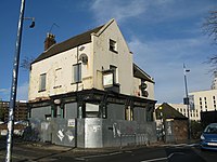 | II | 1075598 [18] | |
| The Garden House | Hagley Road, Edgbaston, B16 | c. 1825 – c. 1875 |  | II | 1075559 [19] | |
| Golden Lion Inn | Cannon Hill Park, Lee Bank, B5 | c. 1500 – c. 1550 | 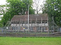 | II | 1075704 [20] | |
| The Gothic | Great Hampton St, Jewellery Quarter, B18 | c. 1875 – c. 1880 |  | II | 1075539 [21] | |
| The Great Stone | Church Rd, Northfield, B31 | c. 1700 – c. 1800 |  | II | 1075657 [22] | |
| Gunmakers Arms | Bath St, Gun Quarter, B4 | c. 1820 |  | II | 1219930 [23] | |
| Gunmaker's Arms | Gerrard St, Lozells, B19 | c. 1908 | 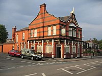 | II | 1211229 [24] | |
| Hare and Hounds | High St, Kings Heath, B14 | 1907 | 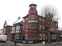 | II | 1217149 [25] | |
| Hen and Chickens (formerly The Hen Bar & Grill) | Constitution Hill, Hockley, B19 | c. 1880 |  | II | 1290561 [26] | |
| The Ivy Bush | Hagley Rd, Edgbaston, B16 | c. 1825 – c. 1875 |  | II | 1211697 [27] | |
| Jewellers Arms | Hockley Hill, Hockley, B18 | c. 1840 |  | II | 1343076 [28] | |
| Lad in the Lane | Bromford Ln, Erdington, B8 | c. 1306 – c. 1400 | 52°30′53″N1°50′08″W / 52.51468°N 1.83548°W |  | II | 1343361 [29] |
| The Lost and Found (formerly Bennetts Bar) | Bennetts Hill, City Centre, B1 | 1869 |  | II* | 1291206 [30] | |
| The Maggies | Shirley Rd, Hall Green, B28 | 1935 |  | II | 1245354 [31] | |
| Market Tavern | Moseley St, Digbeth, B12 | 1899–1900 | 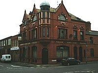 | II | 1234220 [32] | |
| The Marlborough | Anderton Rd, Sparkbrook, B11 | 1900 | 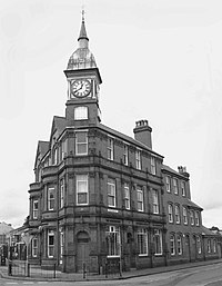 | II | 1393553 [33] | |
| Moseley Arms | Ravenhurst St, Highgate, B12 | c. 1840 | 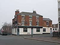 | II | 1343145 [34] | |
| The Old Crown | High St, Deritend, B12 | c. 1500 – c. 1550 | 52°28′29″N1°53′01″W / 52.4747°N 1.8836°W |  | II* | 1076298 [35] |
| Old Royal | Church St, City Centre, B3 | c. 1850 – c. 1900 |  | II | 1343389 [36] | |
| Plough and Harrow | Hagley Rd, Edgbaston, B16 | 1832-3 | 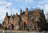 | II | 1076347 [37] | |
| The Pig and Tail (formerly George & Dragon) | Albion St, Jewellery Quarter, B1 | c. 1820 – c. 1870 | 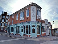 | II | 1343354 [38] | |
| Poachers Pocket | Cole Hall Ln, Shard End, B34 | c. 1600 – c. 1700 |  | II | 1075632 [39] | |
| Popworld (formerly Flares) (formerly a Presbyterian church) | Broad St, City Centre, B1 | 1848-49 |  | II | 1343341 [40] | |
| Queens Arms | Newhall St, Hockley, B3 | c. 1870 | 52°29′01″N1°54′24″W / 52.4836°N 1.9066°W | 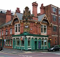 | II | 1392799 [41] |
| Red Lion | Soho Rd, Handsworth, B21 | 1901-2 | 52°30′15″N1°56′17″W / 52.504173°N 1.937968°W |  | II* | 1276278 [42] |
| Red Lion | Vicarage Rd, Kings Heath, B14 | 1903 | 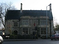 | II | 1210320 [43] | |
| The Red Lion | Warstone Ln, Jewellery Quarter, B18 | c. 1850 – c. 1900 | 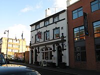 | II | 1392832 [44] | |
| Reflex (formerly The Crown) | Broad St, City Centre, B1 | c. 1750 – c. 1800 | 52°28′42″N1°54′38″W / 52.4782216°N 1.9106478°W | 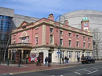 | II | 1220278 [45] |
| Rose Villa Tavern | Warstone Ln, Jewellery Quarter, B18 | 1919–20 | 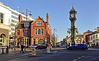 | II | 1271966 [46] | |
| Swan and Mitre | Lichfield Rd, Aston, B6 | 1898-9 |  | II | 1234169 [47] | |
| Tyburn House | Kingsbury Rd, Erdington, B35 | 1930 |  | II | 1234170 [48] | |
| Villa Tavern | Nechells Park Rd, Nechells, B7 | 1924-5 |  | II | 1387740 [49] | |
| Walkabout | Broad St, City Centre, B1 | c. 1860 |  | II | 1075689 [50] | |
| White Hart | Gressel Ln, Tile Cross, B33 | c. 1700 – c. 1750 |  | II | 1211523 [51] | |
| White Swan | Bradford St, Digbeth, B5 | 1899–1900 |  | II | 1276272 [52] | |
| White Swan | Harborne Rd, Edgbaston, B15 | c. 1800 – c. 1850 | 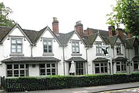 | II | 1343047 [53] | |
| Wine Lord | Constitution Hill, City Centre, B19 | c. 1885 – c. 1890 |  | II | 1343377 [54] | |
| The Woodman | Albert St, Digbeth, B5 | 1896-7 | 52°28′54″N1°53′13″W / 52.481751°N 1.886858°W | 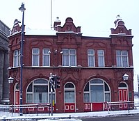 | II | 1234088 [55] |
| The Wellington | 37, Bennett's Hill, B2 | 1868-70 | 52°28′50″N1°54′02″W / 52.480613°N 1.9004641°W |  | II | 1472392 [56] |
| The Wellington Hotel | 72 Bristol Street, B5 | 1890 | 52°28′19″N1°53′57″W / 52.471927°N 1.8991881°W |  | II | 1472392 [57] |
| Zara's (formerly Old Orleans) | Broad St, City Centre, B1 | 1814 |  | II | 1075733 [58] |