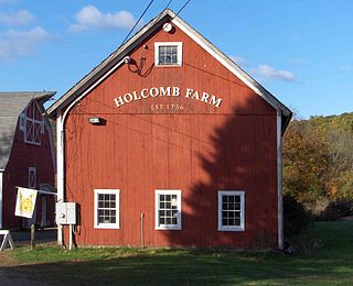
Millington is a village within the town of East Haddam, Connecticut. Millington lies halfway between East Haddam center and Salem center. It is the section of East Haddam that is the closest to Devil's Hopyard State Park. The village is connected to East Haddam Center and to Devil's Hopyard State Park by a series of secondary roads that are maintained by the state. The road is given an unsigned designation "Special Service Road 434", which runs on Mount Parnassus Road, Millington Road, Haywardville Road, and Hopyard Road.

The Canterbury Center Historic District is a historic district in Canterbury, Connecticut. The district is centered on the town green, located at the junction of Route 169 and Route 14. It has been the town center since 1705, and includes a fine assortment of 18th and early 19th-century architecture. It was listed on the National Register of Historic Places (NRHP) in 1998.
The Farmington Historic District encompasses a 275-acre (111 ha) area of the town center of Farmington, Connecticut. It was listed on the National Register of Historic Places in 1972. The area roughly corresponds to the section of Route 10 between Route 4 and U.S. Route 6, and includes 115 buildings, primarily residences, built before 1835. The district includes several National Historic Landmarks, include Hill-Stead, the Austin F. Williams Carriagehouse and House, the First Church of Christ, Congregational, and the Stanley-Whitman House.

The Thompson Hill Historic District encompasses the historic village center of Thompson, Connecticut. The district covers 550 acres (220 ha), whose central focus is the Thompson Center Green, laid out when the town was established in 1735. Thompson Hill was the town's early civic and economic center, later supplanted by industrial villages, and retains well-preserved architecture from the 18th and early 19th centuries. The district was listed on the National Register of Historic Places in 1987.

The Middle Haddam Historic District is a historic district in the town of East Hampton, Connecticut. It encompasses the village center of Middle Haddam, a riverfront community founded in the 17th century on the east bank of the Connecticut River. It was an important port on the river between about 1730 and 1880. Its layout and architecture are reflective of this history, and by the geographic constraints of the local terrain. The district was listed on the National Register of Historic Places in 1984.

The Glastonbury-Rocky Hill Ferry Historic District is a historic district in Glastonbury and Rocky Hill, Connecticut, encompassing a landscape with more than 300 years of colonial and post-colonial history. It includes the ferry landings and water traversed by the Rocky Hill – Glastonbury Ferry, one of the longest-running ferry services the nation, and the surrounding farmscapes and ferry landing village. The district was listed on the National Register of Historic Places in 2005.
The West Granby Historic District is a historic district in Granby, Connecticut. It encompasses the historic village of West Granby, which extends along Simsbury Road between Firetown Road and Hartland Road. Although this area was settled in the 18th century, and has a few surviving buildings from that time, its most significant period of development was in the 19th century, when industry came to play a role in the area. The district was listed on the National Register of Historic Places in 1992.

The Hadley Center Historic District is an expansive, 2,500-acre (1,000 ha) historic district encompassing the village center of Hadley, Massachusetts. When it was first listed on the National Register of Historic Places in 1977, the district encompassed the town green and 17 buildings that faced it, at the junction of Russell Street and Middle Street. The district was expanded significantly in 1994, adding more than 400 buildings representative of the village's growth from colonial days into the first decades of the 20th century. This expansion encompasses the entirety of a tongue of land extending west from East Street and bounded by a bend in the Connecticut River, which separates Hadley from Northampton. Its oldest property, the Samuel Porter House on West Street, was built in 1713.
The Northford Center Historic District encompasses the historic village area of Northford in northern North Branford, Connecticut. The basically linear district extends along Middletown Avenue from the village center at its southern end, to a point beyond its northern junction with Old Post Road. The area was settled in the early 18th century, and was transformed into a rural industrial village in the 19th century by the locally prominent Maltby and Fowler families. It was listed on the National Register of Historic Places in 2002.

The Downtown Norwich Historic District is a historic district representing the core of the downtown area of the city of Norwich, Connecticut in the United States. It was listed on the National Register of Historic Places in 1985. It includes 115 contributing buildings and one other contributing structure over a 64-acre (26 ha) area. Several buildings in the historic district are also individually listed on the National Register, including the Norwich Town Hall, the Telephone Exchange Building and the Carroll Building.

The Belltown Historic District encompasses the historic commercial and industrial main village of East Hampton, Connecticut. Settled in the 18th century, the community flourished in the 19th century as a center of bell making, with numerous firms engaged in the trade. The town center is reflective of this 19th-century success, with a broad diversity of period architecture, as well as surviving elements of the bellmaking industry. The district was listed on the National Register of Historic Places in 1985.
The Mansfield Center Historic District encompasses the historic early village center of Mansfield, Connecticut. First settled about 1692, it is one of the oldest settlements in Tolland County, and retains a strong sense of 18th century colonial layout. It extends along Storrs Street extending from Chaffeeville Road in the north to Centre Street in the south, and was listed on the National Register of Historic Places in 1972.

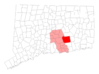
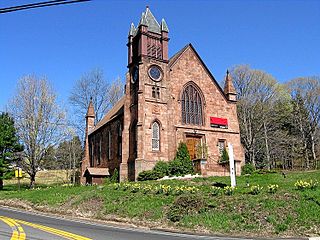
The East Haddam Historic District is a 110-acre (45 ha) historic district in East Haddam, Connecticut representing the historical development of two 18th-century settlements of the town on the east bank of the Connecticut River, Upper Landing and Lower Landing. The district is linear and runs along Route 149. It was listed on the National Register of Historic Places in 1983, and includes a diversity of 18th and 19th-century styles, as well as the town's main civic structures, and the Goodspeed Opera House. Also included in the district are two monuments, one to Nathan Hale and another to Gen. Joseph Spencer, a park, and a cemetery.
The Haddam Center Historic District is a 267-acre (108 ha) historic district encompassing the institutional and residential center of the town of Haddam, Connecticut that was listed on the National Register of Historic Places in 1989 as a result of efforts by the Haddam Historical Society.

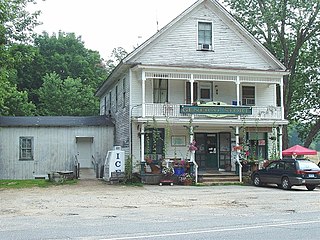
The Hadlyme North Historic District is an 81-acre (33 ha) historic district located in the southwest corner of the town of East Haddam, Connecticut. It represents the historic core of the village of Hadlyme, which straddles the town line, and consists primarily of two north-south roads, Town Street. The village arose around a church society founded in 1743, and grew with the development of small industries along area waterways. It was listed on the National Register of Historic Places in 1988.

The Suffield Historic District is a historic district encompassing the Main Street stretch of the town center of Suffield, Connecticut. The district was listed on the National Register of Historic Places in 1979 and is part of a larger local historic district. It runs along North and South Main Street from Muddy Brook to north of Mapleton Avenue, and includes a diversity of 18th through early 20th-century architecture.

The Central Avenue-Center Cemetery Historic District encompasses part of the town center of East Hartford, Connecticut. Although it was founded in the mid-17th century, it is now dominated by architecture of the late 19th and early 20th centuries. The Center Cemetery is the town's oldest surviving property, and includes the grave of William Pitkin, a colonial governor. The district, including portions of Main Street and Central Avenue, was listed on the National Register of Historic Places in 1993.

The East Granby Historic District encompasses a predominantly rural and agricultural area of the town of East Granby, Connecticut. Extending northward from the town center and covering some two square miles, it includes one of the state's highest concentrations of surviving 18th and early 19th-century farmsteads, and a relatively little-altered landscape. The district was listed on the National Register of Historic Places in 1988.

Guilford Historic Town Center is a large historic district encompassing the entire town center of Guilford, Connecticut. It is centered on the town green, laid out in 1639, and extends north to Interstate 95, south to Long Island Sound, west to the West River, and east to East Creek. It includes more than 600 historic structures, most built between the late 17th and early 20th centuries, reflecting the town's growth and history during that time. It was listed on the National Register of Historic Places in 1976.

The Middlebury Center Historic District encompasses the historic civic and religious center of Middlebury, Connecticut. Centered at the junction of North and South Streets with Whittemore Road, the district includes churches, schools and municipal buildings, many from the late 19th or early 20th centuries, as well as a diversity of residential architecture. The district was listed on the National Register of Historic Places in 1985.