
This is a list of properties and historic districts in Missouri on the National Register of Historic Places. There are NRHP listings in all of Missouri's 114 counties and the one independent city of St. Louis.

U.S. Route 66, the historic east–west US highway between Chicago, Illinois and Santa Monica, California, passed through one brief segment in the southeastern corner of Kansas. It entered the state south of Baxter Springs and continued north until it crossed Brush Creek, from where it turned east and left the state in Galena. After the decertification of the highway in 1985, this road segment was numbered as US-69 (alternate) from Quapaw, Oklahoma north to Riverton, Kansas and as K-66 from Riverton east to Route 66 in Missouri.

The Wilson Building is an historic 8-story building in the Main Street district of downtown Dallas, Texas. The building was completed in 1904 and patterned after the Palais Garnier in Paris, France. The historic structure fronts Main Street on the south, Ervay Street on the east, and Elm Street on the north. The Wilson building was the tallest structure in Dallas from 1904–1909 and was considered the premier commercial structure west of the Mississippi. The Wilson Building is situated across from the flagship Neiman Marcus Building and is adjacent to the Mercantile National Bank Building.

Fort Omaha, originally known as Sherman Barracks and then Omaha Barracks, is an Indian War-era United States Army supply installation. Located at 5730 North 30th Street, with the entrance at North 30th and Fort Streets in modern-day North Omaha, Nebraska, the facility is primarily occupied by the Metropolitan Community College. A Navy Operational Support Center and Marine Corps Reserve unit, along with an Army Reserve unit occupy the periphery of the 82.5 acres (33.4 ha) fort. The government deeded all but four parcels of the land to the Metropolitan Community College in 1974.

The Pony Express Terminal, also known as the B. F. Hastings Bank Building, is a historic commercial building at 1000 2nd Street in Sacramento, California. Built in 1852, it was the western endpoint of the Pony Express from 1860 to 1861, the period of the service's operation. It was declared a National Historic Landmark in 1966. It now houses a museum dedicated to the history of Wells Fargo, and is part of Old Sacramento State Historic Park, itself a National Historic Landmark District.
Van Meter State Park is a public recreation area on the Missouri River in Saline County, Missouri. The state park consists of 1,105 acres (447 ha) of hills, ravines, fresh water marsh, fens, and bottomland and upland forests in an area known as "the Pinnacles." The park has several archaeological sites, a cultural center, and facilities for camping, hiking, and fishing. It is managed by the Missouri Department of Natural Resources.
Knob Noster State Park is a public recreation area covering 3,934 acres (1,592 ha) in Johnson County, Missouri, in the United States. The state park bears the name of the nearby town of Knob Noster, which itself is named for one of two small hills or "knobs" that rise up in an otherwise flat section of Missouri. Noster is a Latin adjective meaning "our"—therefore, Knob Noster translates as "our hill." A local Indian belief stated that the hills were "raised up as monuments to slain warriors." The park offers year-round camping, hiking, and fishing and is managed by the Missouri Department of Natural Resources.
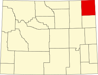
This is a list of the National Register of Historic Places listings in Crook County, Wyoming.
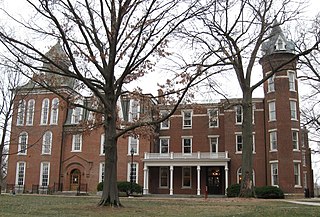
Historic Senior Hall on the Stephens College campus in Columbia, Missouri dates back to 1841, when Oliver Parker bought the eight-acre tract of land on which the College was first located. In 1857, the Columbia Baptist Female College, which later became Stephens College, acquired the building. Until 1918, Historic Senior Hall was the only dormitory at the College. It was the tradition for the President of the Civic Association to occupy the first floor room just north of the Waugh Street entrance. A complete restoration of Historic Senior Hall began in the spring of 1987, and the building was rededicated in the spring of 1990. The historic auditorium was demolished as a cost saving measure in 2000.
Walter David Pugh was an American architect based in Salem, Oregon, United States.

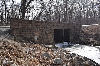
The DXN Bridge over the Little Missouri River is one of a group of thirty-one bridges in Wyoming that were collectively listed on the National Register of Historic Places as excellent examples of steel truss bridges of the early 20th century. The DXN Bridge is located in Crook County, Wyoming. It is a single-span of about 72 feet (22 m), an 8-bay Pratt pony truss on Crook County Road 18-200. It was built about 1920. The bridge is unique in lacking inclined end posts.

This is a list of the National Register of Historic Places listings in Cooper County, Missouri.

The National Register of Historic Places listings in downtown Kansas City, Missouri is intended to be a complete list of the properties and districts on the National Register of Historic Places in downtown Kansas City, Missouri, United States. Downtown Kansas City is defined as being roughly bounded by the Missouri River to the north, 31st Street to the south, Troost Avenue to the east, and State Line Road to the west. The locations of National Register properties and districts are in an online map.

Monarch Engineering Co. was an American firm of Denver, Colorado, active in engineering and construction services. John A. Crook and his brother, Guy A. Crook of Falls City, were founders of the Monarch Engineering company which had its origin and main offices at Falls City, with offices in Kansas City, and Denver. Under the management of these men the Monarch Engineering company had risen to become an important and prosperous concern and a vast amount of bridge construction, city paving, irrigation-dam building, and public building work has been done under their supervision. Within ten years after the firm had been in operation, or since 1908, its activities constantly increased and in 1917 they purchased the Denver Steel and Iron Works in order to facilitate the material supply part of the construction work in which they were engaged.
The Planters Bank Building is a historic commercial building at 200 East Hale Street in downtown Osceola, Arkansas. It is a Classical Revival brick and mortar structure, designed by Missouri architect Uzell Singleton Branson and built c. 1920. It is one of the most architecturally sophisticated buildings in the city, which is otherwise dominated by vernacular early 20th-century commercial architecture. It has housed banks for most of its existence, although it briefly served as city hall in 1943–44.
Lloyd England Hall is a historic building at the northwest corner of 6th and Missouri Streets, on the grounds of Camp Joseph T. Robinson, an Arkansas National Guard base in North Little Rock, Arkansas. It is a Spanish Revival structure, designed by the Little Rock architectural firm of Thompson, Sanders, and Ginnochio, and built in 1931, when the facility was known as Camp Pike. Originally built as an auditorium and meeting hall, it is now home to the Arkansas National Guard Museum.

North Little Rock City Hall is located at 300 Main Street in North Little Rock, Arkansas. It is a Classical Revival two-story building, with an exterior of stone with terra cotta trim. Prominent features of its street-facing facades are massive engaged two-story fluted Ionic columns. It was built in 1914–15, and is based on the design of a bank building seen by Mayor J.P. Faucette in St. Louis, Missouri.

The Missouri Lumber and Mining Company (MLM) was a large timber corporation with headquarters and primary operations in southeast Missouri. The company was formed by Pennsylvania lumbermen who were eager to exploit the untapped timber resources of the Missouri Ozarks to supply lumber, primarily used in construction, to meet the demand of U.S. westward expansion. Its primary operations were centered in Grandin, a company town it built starting c. 1888. The lumber mill there grew to be the largest in the country at the turn of the century and Grandin's population peaked around 2,500 to 3,000. As the timber resources were exhausted, the company had to abandon Grandin around 1910. It continued timber harvesting in other parts of Missouri for another decade. While some of the buildings in Grandin were relocated, many of the remaining buildings were listed on the National Register of Historic Places in 1980 as part of the state's historic preservation plan which considered the MLM a significant technological and economic contributor to Missouri.

